

Chicago Storm
-
Posts
18,587 -
Joined
-
Last visited
Content Type
Profiles
Blogs
Forums
American Weather
Media Demo
Store
Gallery
Everything posted by Chicago Storm
-
They tend to do that at times, and there's no real rhyme or reason as to why.
-

Chicago Weather Records Tracking
Chicago Storm replied to Chicago Storm's topic in Lakes/Ohio Valley
It's more-so that the observation location was either by the lake or downtown. -
Posted this in the Chicago record thread, but figured it was worth the cross-post here as well. All-time and daily record temperatures in jeopardy the next few days... •Winter all-time record max temp - 75° (2/27/1976) •February all-time record max temp - 75° (2/27/1976) •February all-time record min temp - 54° (2/8/1925) •Monday, Feb 26th Max Temp - 64° (2000) •Tuesday, Feb 27th Max Temp - 75° (1976) •Tuesday, Feb 27th Min Temp - 42° (1896)
-
Chicago Weather Records Tracking
Chicago Storm replied to Chicago Storm's topic in Lakes/Ohio Valley
All-time and daily record temperatures in jeopardy the next few days... •Winter all-time record max temp - 75° (2/27/1976) •February all-time record max temp - 75° (2/27/1976) •February all-time record min temp - 54° (2/8/1925) •Monday, Feb 26th Max Temp - 64° (2000) •Tuesday, Feb 27th Max Temp - 75° (1976) •Tuesday, Feb 27th Min Temp - 42° (1896) -
Chicago Weather Records Tracking
Chicago Storm replied to Chicago Storm's topic in Lakes/Ohio Valley
The big dog one to watch... No chance at the warmest winter on record, but getting into the top 5 is certainly possible. Warmest Winter’s 1. 37.2° - 1877/88 2. 35.7° - 1931/32 3. 35.2° - 1879/80 4. 35.1° - 1881/82 5. 34.6° - 1889/90 6. 34.4° - 2023/24 (Thru 2/24) 7. 33.6° - 1875/76 8. 33.2° - 1997/98 9. 33.1° - 1918/19 10. 32.8° - 2011/12 10. 32.8° - 1920/21 -
There’s essentially no chance at a heat index that high, with relatively low dew points expected. (DP’s will be high by Feb standards, but low for getting a 90°+ HI.)
-
The 0.6” of snow at MLI on the month would tie for 7th least snowy.
-
Chicago Weather Records Tracking
Chicago Storm replied to Chicago Storm's topic in Lakes/Ohio Valley
With the 1.2” of snow at ORD on Friday evening, which is now the February monthly total, it ends the pursuit of a top 10 least snowy February. -
Snowed for several hours at ORD on Friday evening, with a solid period of borderline SN and a burst of +SN. Final event snowfall total of 1.2” at ORD, 2.2” at MDW, and 1.0” at RFD. 2.0” at home.
-
Chicago Weather Records Tracking
Chicago Storm replied to Chicago Storm's topic in Lakes/Ohio Valley
wrong thread, guy. -
Winter '23-'24 Piss and Moan/Banter Thread
Chicago Storm replied to IWXwx's topic in Lakes/Ohio Valley
greetings from the south end of the airport. -
Winter '23-'24 Piss and Moan/Banter Thread
Chicago Storm replied to IWXwx's topic in Lakes/Ohio Valley
useless record ruining stat-padding snow tonight. -
Chicago Weather Records Tracking
Chicago Storm replied to Chicago Storm's topic in Lakes/Ohio Valley
And just like that... We are not only out of the running for least snowy February on record, but we are out of the running for top 5 least snowy as well. -
Chicago Weather Records Tracking
Chicago Storm replied to Chicago Storm's topic in Lakes/Ohio Valley
Running the numbers just roughly off of the NWS forecast (Likely underdone a bit early next week), we are in the running for the top 5 warmest, but not close to 1st. We would need temps to overperform their current forecast by quite a bit to make a run at the record warmest. -
Chicago Weather Records Tracking
Chicago Storm replied to Chicago Storm's topic in Lakes/Ohio Valley
A tie for the least snowiest February is in serious jeopardy this evening/tonight. Luckily, I'm working... -
Most of that is fake LES snow. The HRRR is still terrible in handling LES for some reason. It’s almost always significantly overdone.
-
Winter 2023/24 Medium/Long Range Discussion
Chicago Storm replied to Chicago Storm's topic in Lakes/Ohio Valley
The PDO does have an effect. However, one single factor does not dictate the outcome as a whole, multiple factors do. -
I was out biking in the preserve across from home before work today and noticed several species of trees are budding...especially some types of maples. Came across one tree in particular that had moved past budding and was beginning to green out. Can't recall seeing that occur this early before, even in years with warmer February periods.
-
the climate non-sense in every thread has gotten old quick.
-
Winter 2023/24 Medium/Long Range Discussion
Chicago Storm replied to Chicago Storm's topic in Lakes/Ohio Valley
read more, post less. -
Winter 2023/24 Medium/Long Range Discussion
Chicago Storm replied to Chicago Storm's topic in Lakes/Ohio Valley
As mentioned a few days ago, the seasonal demise of the SPV continues to be on the horizon, and earlier than average. This is a warming to demise evolution.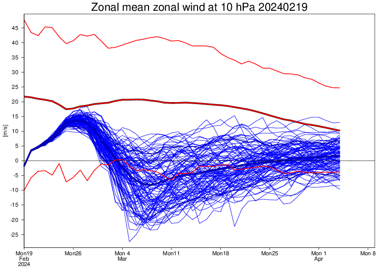
-
Winter 2023/24 Medium/Long Range Discussion
Chicago Storm replied to Chicago Storm's topic in Lakes/Ohio Valley
like any other winter, nothing new there. -
Chicago Weather Records Tracking
Chicago Storm replied to Chicago Storm's topic in Lakes/Ohio Valley
Several things to watch as we head towards the conclusion of February... Warmest February's 1. 39.0° - 1882 2. 38.7° - 1998 3. 38.0° - 2017 4. 37.5° - 1954 5. 37.3° - 1877 6. 37.1° - 1930 7. 36.6° - 2024 (Thru 2/18) 8. 36.5° - 1878 9. 35.8° - 1976 10. 35.6° - 1931 Least Snowy February's 1. T - 2024 (Thru 2/18) 1. T - 2017 1. T - 1998 1. T - 1987 5. 0.3" - 1996 5. 0.3" - 1921 7. 0.4" - 1995 8. 0.4" - 1931 9. 0.5" - 1915 10. 0.9" - 1922 Driest February's 1. 0.06" - 1877 2. 0.10" - 2024 (Thru 2/18) 3. 0.13" - 1920 4. 0.19" - 2003 5. 0.25" - 1969 6. 0.33" - 1958 7. 0.38" - 1947 7. 0.38" - 1921 9. 0.41" - 1995 9. 0.41" - 1982 -
Winter '23-'24 Piss and Moan/Banter Thread
Chicago Storm replied to IWXwx's topic in Lakes/Ohio Valley
The lake likely added up to 6-10” in NE IL. -
Winter 2023/24 Medium/Long Range Discussion
Chicago Storm replied to Chicago Storm's topic in Lakes/Ohio Valley
Yea, guidance has backed off of showing a full blown SSWE, but we are most definitely seeing significant stratospheric warming. The effects are and will be similar to that of an actual SSWE, with high latitude blocking. However, given the pattern alignment and the lack of MJO support, it is unlikely to bring any consistent, significant, noteworthy, or interesting wintry weather to these parts, at least for the foreseeable future.


