Chicago Storm
-
Posts
19,240 -
Joined
-
Last visited
Content Type
Profiles
Blogs
Forums
American Weather
Media Demo
Store
Gallery
Everything posted by Chicago Storm
-
3,491 cases and 47 deaths as of Saturday. .
-
wut
-
3,026 cases and 34 deaths total in IL now.
-
673 new cases and 7 new deaths in IL. 2,536 cases and 26 deaths total now.
-
.
-
Continue to closely monitor Saturday for a potential local-ish chase. There several things to like, but also several things to hate about the set-up at this point.
-
I guess maybe the good news is that we are not seeing their numbers jump much higher now? Deaths per day seem to have leveled off to a 650-750 range, which is obviously not good, but luckily the trend upward has not continued.
-
They're not. However, the main point is that the $ will be just an advancement on your 2020 tax return. So come next year, there's gonna be a lot of unhappy people.
-
Can’t help but lol at the people (which is many) who actually think they’re about to get “free” money from the government. .
-
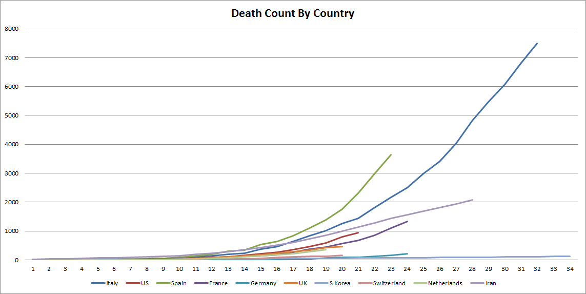
Spain is in way worse shape than Italy...and that's kind of hard to accomplish...

-
Yea, people followed the shelter-in-place order for about two days. Local traffic was back to usual Wednesday standards around here, with pretty much any business that was open having a decently filled lot. And I should point out there are a lot of non-essential businesses that are still open. Tons of people were outdoors too, with the nice weather today.
-
1,865 cases and 19 deaths total in IL now. 300+ new cases and 3 new deaths, since yesterday.
-
At that point I had only looked at the GFS, given it was only GFS/Euro out far enough.
-
I'll even chalk an lol up on this one.
-
The rare IL dry-line is looking like a good possibility. However...lapse rates look poor and the potential for widespread warm sector debris is high.
-
1,535 cases and 16 deaths in IL now.
-
1,285 total IL cases now, with 3 new deaths to make 12 total.
-
IL is up to 9 deaths and 1,049 total cases. .
-
Up to 753 cases and 6 deaths in IL. .
-
With word out that this is going to occur, chaos has ensued. Walmart is beyond packed...There's a line just to get into the building. Police everywhere.
-
Illinois is expected to be placed under a shelter-in-place order during todays news conference, which will go into effect on Saturday.
-
It's a good thing you didn't, as the cold front under-cut just about everything.
-
He said the same thing the past few days.
-
He didn't change/do anything.
-
134 new IL cases, and 422 total now. 3 new deaths, with 4 total now.