

Chicago Storm
-
Posts
18,587 -
Joined
-
Last visited
Content Type
Profiles
Blogs
Forums
American Weather
Media Demo
Store
Gallery
Everything posted by Chicago Storm
-
First serial derecho in the region in quite a while. .
-
91 at ORD and MDW today. 88 here, with a bit more clouds being further west. .
-
"Storm" earlier just after 3PM with the initial feeder band ended up having enough wind to take down a ~1 foot diameter tree in the neighbors yard. Rapid increase in synoptic winds recently now, just took down another tree in a different neighbors yards. Could hear cracking of likely smaller branches in the distance with the bigger gusts.
-
A bit south of IKK a bit ago...
-
Several rotating showers in southern LOT CWA currently.
-
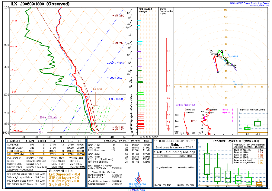
18z ILX sounding was tropical...
-
62MPH wind gust at MDW. TDWR suggests 70-75MPH winds just west of MDW.
-
I had my fill of tropical showers in FL. High wind/tor potential or pass.
-
Slight risk can probably be dropped in the region with the 20z outlook. Afternoon/evening threat looks to be significantly hindered by widespread clouds and ongoing activity. Overnight threat is still there, but looks marginal. .
-
Hopefully the SPC isn’t dumb enough to actually go 10% tor for anywhere in the region today. .
-
Not really sure why we needed a new thread for severe. That’s a big chunk of the other thread. .
-
Sunset yesterday was tops. .
-
9z RAP with 50-55kt at 950mb this evening, with mixing to above that. .
-
Compared to remnants events, yea. But this is looking like the standard 40-55mph locally higher type of event we see at least once every spring/fall.
-
The few soundings I had looked at were not as great as a day ago. In regards to getting the goods to the surface, that is.
-
90 at ORD today. 91 at MDW and here. .
-
The bullish Euro has backed off on the winds, and is falling more in line with the rest of the pack. Looking more likely we end up with a usual 40-55mph wind event, locally higher. There does appear to be some tor threat, but greatest will be much further S and SE. .
-
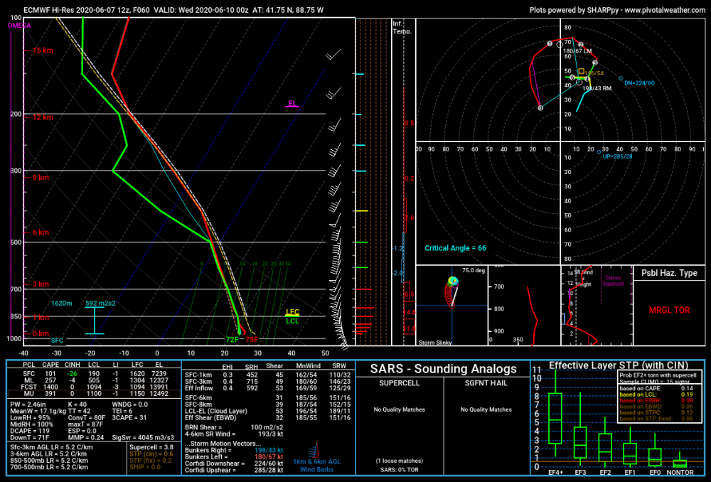
For 0z Wed out of DeKalb Co...
-
.
-
.
-
Definitely looking more and more likely that this will be something many of us have not seen around these parts, re: post-TC high/sig winds.
-
92 here yesterday. Was cooler at ORD and MDW due to the lake breeze. 91 here today, and 89 at ORD and MDW, where thicker cirrus held on a bit longer.
-
A repeat of that shifted up this way would be perfect. .
-
Highest it'll get all month, right?
-
Winds increased here on the backside of that activity as well. Likely was a weak wake low, especially given radar velo presentation.


