Chicago Storm
-
Posts
18,587 -
Joined
-
Last visited
Content Type
Profiles
Blogs
Forums
American Weather
Media Demo
Store
Gallery
Everything posted by Chicago Storm
-

May 2024 General Discussion
Chicago Storm replied to HillsdaleMIWeather's topic in Lakes/Ohio Valley
That's because this stretch that we're in also had the great record breaking February, something 2012 fell short on (In comparison). So in other words, 2024 February thru Mid-May has had better consistency and longevity in terms of mild/warm temps and nice weather. -
A bit late to getting to some of this, so playing catch-up... Chased two multi-mode severe t'storms across portions of Western and Northwestern Illinois on Tuesday, April 16th. Encountered a wall cloud, nickel size hail, 40-50MPH winds, and a gustnado with the activity. A combination of not planning on heading into Iowa, leaving a bit late, and not wanting to deal with the lack of Mississippi River crossings along the Iowa/Illinois border prevented me from seeing any of the tornado action in SE. Iowa. And naturally, the tornado threat vaporized after activity crossed the border into Illinois, due to limited recovery time in the wake of the first round of activity. Chased a supercell severe t'storm across portions of Central Illinois on Thursday, April 18th. Encountered two funnel clouds and 40-50MPH winds with the activity. I really didn't plan on chasing this day, but I was down in C. Illinois for something and activity came close enough for me to mess around with it for a short time. The best part was a close encounter with a rain wrapped couple of supercell t'storm that was overtaken by a QLCS. It gave it a solid effort in producing a tornado in the heavy rain, in a field right across from me just outside of Raymond, IL (Pictured below).
-
Spring/Summer '24 Banter and Complaint Thread
Chicago Storm replied to IWXwx's topic in Lakes/Ohio Valley
I thought it looked familiar, but couldn't put my finger on exactly which species it was. The majesty palm is somewhat cold hardy, but not as much so as a few other species. -
May 2024 General Discussion
Chicago Storm replied to HillsdaleMIWeather's topic in Lakes/Ohio Valley
That shit was amazing. Sat out in NW. Illinois from when it cleared ~11:30PM till 3AM. I should have stayed longer too, with a secondary peak 3:30-4:30AM, but I was barely hanging on as it was. Too many pictures to even go through, but hopefully will have a few up eventually. -
May 2024 General Discussion
Chicago Storm replied to HillsdaleMIWeather's topic in Lakes/Ohio Valley
Will be headed up to NW. Illinois after work later for the Northern Lights, if things are still looking good. That area will have the best combination of the least amount of light pollution and earliest exit of clouds. -
May 2024 General Discussion
Chicago Storm replied to HillsdaleMIWeather's topic in Lakes/Ohio Valley
Numerous areas are experiencing a few different heat bursts in a corridor from E. Nebraska/Omaha area into N. Illinois tonight, as decaying clusters of showers/t'storms work through. This beneath a nice plume of solid lapse rates and a solid inversion with a deep layer of warmer/drier air just off the deck. MLE out near Omaha is probably the best example I can find, from from 60/46 to 70/33. -
The environment around here won’t be bad this afternoon, right under the head of the jet streak and with a small plume of better ML lapse rates. Could have a sneaky decent last minute severe threat across the area for a brief window this afternoon, before things quickly slide into MI/IN.
-
Wednesday has a much higher ceiling than tomorrow.
-
don't get ahead of yourself...
-
Spring/Summer '24 Banter and Complaint Thread
Chicago Storm replied to IWXwx's topic in Lakes/Ohio Valley
it’s hard to tell what the bottom one is, but the top is a needle palm. solid cold hardy palm there. -
Tuesday is most interesting on the Euro, if comparing the three OP globals at this range.
-
Spring 2024 Medium/Long Range Discussion
Chicago Storm replied to IWXwx's topic in Lakes/Ohio Valley
-
Severe Weather 4-25 through 4-28-24
Chicago Storm replied to cheese007's topic in Central/Western States
CC signature is 1 mile wide on radar. -
Severe Weather 4-25 through 4-28-24
Chicago Storm replied to cheese007's topic in Central/Western States
Moving into populated far west “suburbs” of Omaha now… -
Severe Weather 4-25 through 4-28-24
Chicago Storm replied to cheese007's topic in Central/Western States
SPC doing a shit job per usual today. -
Spring 2024 Medium/Long Range Discussion
Chicago Storm replied to IWXwx's topic in Lakes/Ohio Valley
I really haven't had time to get into any medium or long range thoughts for quite a while, but... If you're into hyper-active patterns with consistent t'storm/severe t'storm potential and consistently warmer temps, the pattern we are sliding into is for you. One thing to note, though, is that the western/southwestern half of the sub-forum on into the Central US may be favored for the aforementioned. ENS are in agreement on consistent troughing into the PAC NW and potentially deeper into the West Coast, which should allow for a parade of disturbances/storm systems to eject across the Central US. This all begins with the first storm system coming up to end this week, and it may very well continue right on into the first full week of May. -
Solid dryline across N and W IL this afternoon. Dew points in the low-mid 50's ahead of it, with mid 20's to low 30's behind it.
-
Spring/Summer '24 Banter and Complaint Thread
Chicago Storm replied to IWXwx's topic in Lakes/Ohio Valley
think that they forgot that high wind warnings exist. -
2024 Short/Medium Range Severe Weather Discussion
Chicago Storm replied to Chicago Storm's topic in Lakes/Ohio Valley
Tomorrow is very uncertain and murky at this point. Many more questions than answers. -
First 80°+ high temp of the year at ORD on Sunday, with a high of 81°.
-
i can't do that long of a flight. otherwise i'd head to australia, where they will have four between 2028-2038. i'll have to wait for the back-to-back one's in 2044 and 2045.
-
they are dead to me because they don't offer bbq sauce. horrible establishment.
-
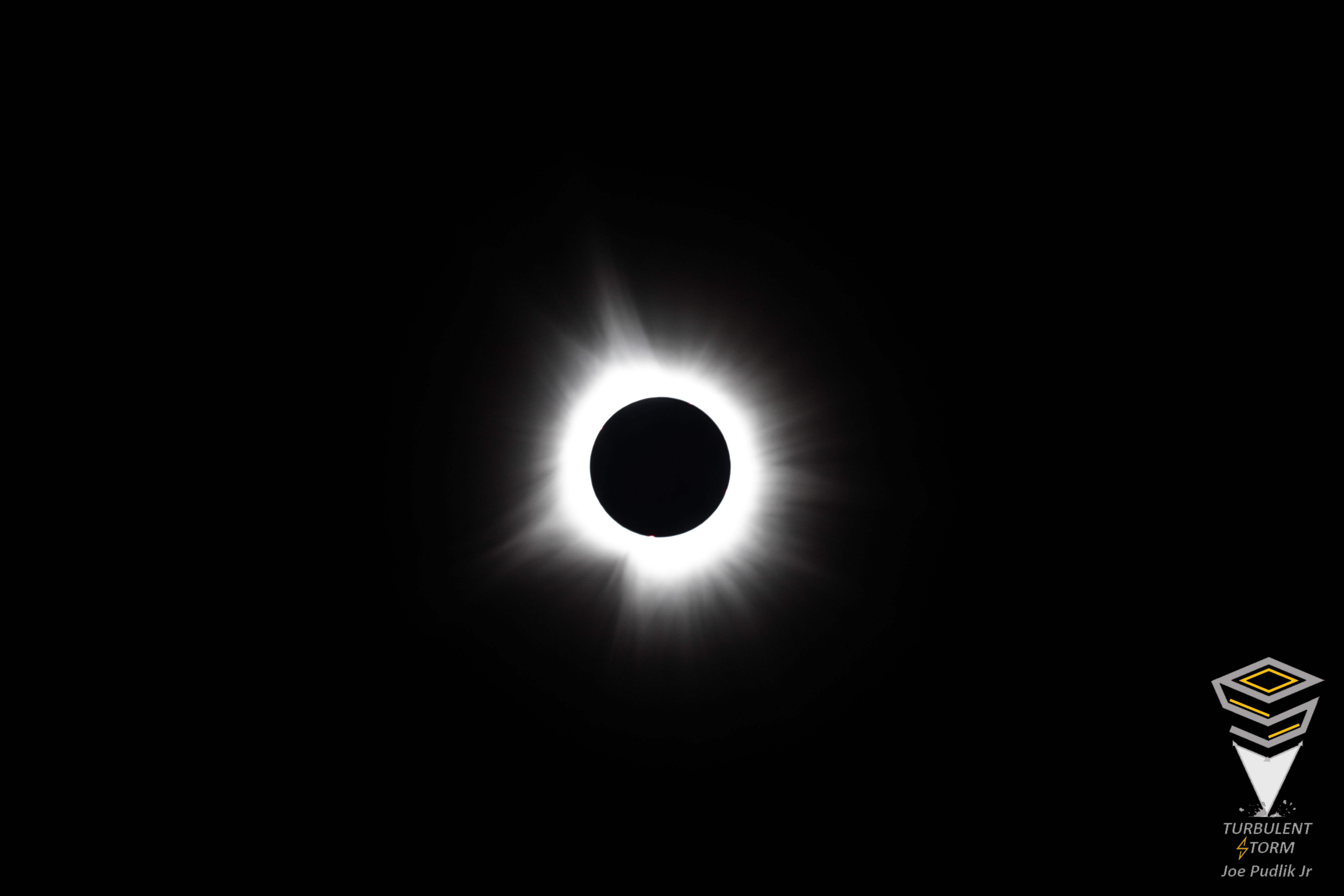
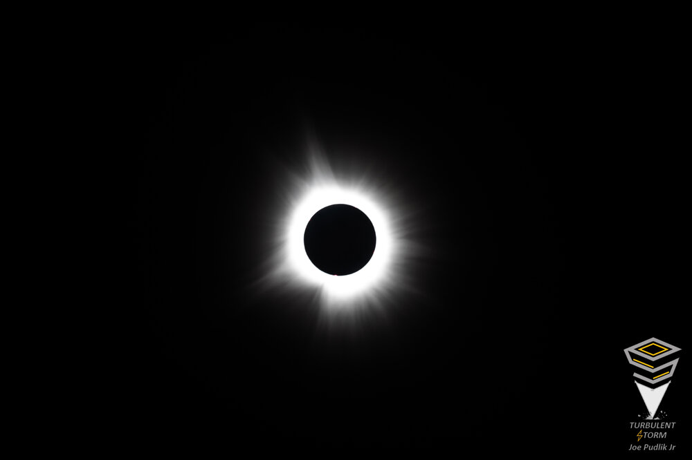
Ended up with great viewing conditions for the eclipse yesterday, as the thicker portion of the high level cirrus cloud deck moved out just in time for totality. As expected, the experience blew out my 15 seconds of totality while riding the edge of the 2017 eclipse just SE of STL. This go-around, having full totality for a solid 4 minutes, was great. I didn't believe it going into it, but it's all true... When totality hits and it goes dark, similar to after sunset on a normal night, things change... Birds got quiet, and nightlife came alive. Instead of having just the western horizon filled with yellow/orange like a normal evening sunset, it was 360° in all directions. In the sky above, it wasn't black and dark like night, but more of a deep/dark navy blue-like shade. Also visible were Jupiter and Venus, as well as eye visible prominence/coronal loop. Looking forward to the next two total eclipse opportunities in 2044 (Montana/Canada) and 2045 (Western/Southern US).
- 121 replies
-
- 15
-

-

-
Stationed near Franklin, IN. As expected, have had high clouds this morning and afternoon here, varying between scattered to overcast at ~30,000KFT. Looks like the thicker stuff should be out of the way in time for totality.
-
Have decided to focus on the IN portion of the corridor I had mentioned. Heading down to Indy later today, and will monitor trends tonight/Monday morning to adjust as needed. For that MO/IL/IN/OH corridor, it seems like the better chance to avoid the worst of the cloud situation is there…possibly.