

Chicago Storm
-
Posts
19,240 -
Joined
-
Last visited
Content Type
Profiles
Blogs
Forums
American Weather
Media Demo
Store
Gallery
Everything posted by Chicago Storm
-

Jan 24-26th Potential Something Part 2
Chicago Storm replied to Chicago Storm's topic in Lakes/Ohio Valley
12z GEFS Mean . -
Jan 24-26th Potential Something Part 2
Chicago Storm replied to Chicago Storm's topic in Lakes/Ohio Valley
next time know what you're talking about first, before trying to claim an lol victory. see above. -
Jan 24-26th Potential Something Part 2
Chicago Storm replied to Chicago Storm's topic in Lakes/Ohio Valley
12z UKMET bumped north and drier. -
Jan 24-26th Potential Something Part 2
Chicago Storm replied to Chicago Storm's topic in Lakes/Ohio Valley
channeling your inner angrysummons here. yes, everyone did know the storm was going to shear apart with eastward extent. i'm not sure there is anyone here that didn't believe that. however, the trend for the storm to end up further northwest in the plains due to additional ridging (in part) is not something that was originally modeled...and is part of why it is shearing out faster as it heads east. please share your crystal ball next time. -
Winter 2020-21 Medium/Long Range Discussion
Chicago Storm replied to Hoosier's topic in Lakes/Ohio Valley
i'm pretty sure he was before your time. -
Winter 2020/2021 Short Range Discussion
Chicago Storm replied to Chicago Storm's topic in Lakes/Ohio Valley
It was mostly virga. -
Jan 24-26th Potential Something Part 2
Chicago Storm replied to Chicago Storm's topic in Lakes/Ohio Valley
12z GEM with a solid bump north and drier. -
Jan 24-26th Potential Something Part 2
Chicago Storm replied to Chicago Storm's topic in Lakes/Ohio Valley
One thing that we have seen change over time is for the storm system to end up further northwest in the Plains, as it ejects out and gets caught in a bit of ridge that extends back up into the Rockies and BC/Alberta. This allows the storm system to peak sooner while out west, before hitting the wall and quickly shearing off to the east.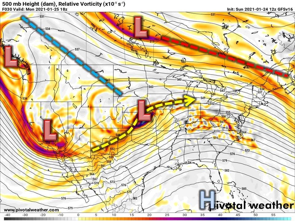
-
Jan 24-26th Potential Something Part 2
Chicago Storm replied to Chicago Storm's topic in Lakes/Ohio Valley
12z GFS keeping with the trend of going drier. -
Jan 24-26th Potential Something Part 2
Chicago Storm replied to Chicago Storm's topic in Lakes/Ohio Valley
12z RGEM bumping south and drier. -
Jan 24-26th Potential Something Part 2
Chicago Storm replied to Chicago Storm's topic in Lakes/Ohio Valley
That has been a large part of it, especially with how much the confluence over the Lakes/Northeast has been changing with time. There have also been some changes with the main southern wave with how far north/south it ejects out, as well as changes with ridging ahead of it. Another thing to watch, is the next trough coming into the West Coast, as that is actually somewhat acting as a kicker for our ejecting southern wave. -
Jan 24-26th Potential Something Part 2
Chicago Storm replied to Chicago Storm's topic in Lakes/Ohio Valley
There were 3 soundings missing in the Southwestern US, which is significant given that is where the main southern trough/wave is located. At the same time, soundings occurred as normal across most of the rest of the US and Canada, which allowed for the open field ahead of the southern wave and the northern stream to be fully sampled still. So probably have some caution, but don't overthink it too much. Edit: Also, some Mexico soundings were missing at times yesterday, but were available this morning. -
Jan 24-26th Potential Something Part 2
Chicago Storm replied to Chicago Storm's topic in Lakes/Ohio Valley
12z NAM . -
Jan 24-26th Potential Something Part 2
Chicago Storm replied to Chicago Storm's topic in Lakes/Ohio Valley
Parts of IA went from 13" 6z run to 0" 12z run. -
Jan 24-26th Potential Something Part 2
Chicago Storm replied to Chicago Storm's topic in Lakes/Ohio Valley
12z NAM is much drier. -
Jan 24-26th Potential Something Part 2
Chicago Storm replied to Chicago Storm's topic in Lakes/Ohio Valley
Confluence in S Canada/N Lakes/Northeast is further south and the southern wave ejects out a bit further south. -
Jan 24-26th Potential Something Part 2
Chicago Storm replied to Chicago Storm's topic in Lakes/Ohio Valley
12z NAM coming in with a big bump south. -
Jan 24-26th Potential Something Part 2
Chicago Storm replied to Chicago Storm's topic in Lakes/Ohio Valley
Very much has been the case over the years. -
Winter 2020-21 Medium/Long Range Discussion
Chicago Storm replied to Hoosier's topic in Lakes/Ohio Valley
probably on point there. -
Jan 24-26th Potential Something Part 2
Chicago Storm replied to Chicago Storm's topic in Lakes/Ohio Valley
3rd main cycle that have been missing them, unfortunately. -
Winter 2020-21 Medium/Long Range Discussion
Chicago Storm replied to Hoosier's topic in Lakes/Ohio Valley
this must be the new model run total snow map thread. -
Winter 2020/2021 Short Range Discussion
Chicago Storm replied to Chicago Storm's topic in Lakes/Ohio Valley
T both at ORD and here. -
Jan 24-26th Potential Something Part 2
Chicago Storm replied to Chicago Storm's topic in Lakes/Ohio Valley
6z Euro bumped back north as well. . -
Jan 24-26th Potential Something Part 2
Chicago Storm replied to Chicago Storm's topic in Lakes/Ohio Valley
Add the GFS and para GFS to the 6z bump north group. . -
Jan 24-26th Potential Something Part 2
Chicago Storm replied to Chicago Storm's topic in Lakes/Ohio Valley
0z Euro .


