

Chicago Storm
-
Posts
18,587 -
Joined
-
Last visited
Content Type
Profiles
Blogs
Forums
American Weather
Media Demo
Store
Gallery
Everything posted by Chicago Storm
-
As is usually an issue in the fall (and spring), a large area of low clouds developed and is only slowly eroding. Currently in the mid 60’s, with 80 looking increasingly unlikely. .
-
Very little color around here so far... A few of the locust trees have started to turn, but outside of that it’s still deep summer lush green. .
-
79’d at ORD for the 3rd consecutive day. .
-
Interesting map. This Sept isn’t a good example though... .
-
Sounds terrible. .
-
Finally had an chance to look into it. Looks like it was either nothing or potentially sensor related. .
-
Made it down to 38 here last night. ORD only bottomed out at 46. Coldest in N IL was 34 at FEP and 37 at ARR/RPJ. .
-
For globals lolz, the GFS has 3 TC in the Gulf/Bay of Campeche between now and mid next week. .
-
Topped out at 84. .
-
It is a possibility... https://rapidrefresh.noaa.gov/hrrr/HRRRsmoke/
-
There's a shot that some of the smoke may make it down to the surface tomorrow in portions of the region, immediately following the frontal passage.
-
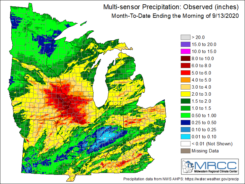
Outside of the initial MCS, most of the activity was oriented more SW-NE. The map that was posted in the Sept thread shows the steady drop off across the central metro on south/southeast fairly well.
-
Quite the turn around... ...IMBY... July 30-Sept 5th... 1.04" Sept 6-13th... 4.28" ...ORD... July 30-Sept 5th... 1.13" Sept 6-13th... 2.54" ...RFD... July 27-Sept 5th... 0.65" Sept 6-13th... 6.01"
-
Summer ended on the 3rd.
-
gonna be mixing a lot fo sho. .
-
The non-lawn foliage was hurting around here. .
-
Are you really surprised with them? .
-
10-15C at 700mb is just about as bad as it gets. There will probably be some t’storms that develop, as cooling occurs aloft... But any severe threat will probably be confined to a small portion of WI/MI, and remain relatively minor. .
-
About as DOA as DOA can get. .
-
Tomorrow looks like a classic day in which morning activity does not clear soon enough and lingers a bit too long, which will hinder cold frontal activity for later in the day. Looks like a marginal risk kind of day. .
-
Drought buster... .
-
Likely have seen the last 90+ day until next year. Pattern the next 2 weeks suggests an average to below average regime, and after that it’s already late Sept and becomes increasingly difficult.
-
city dweller views are obvi skewed. .
-
87 now. Gonna be a close one. .
-
86 now. Looks like it’ll pass ORD by 1:30, so probably will end up being just an hour or so too fast for 90+. Should get to at least 88 though.


