

Chicago Storm
-
Posts
19,122 -
Joined
-
Last visited
Content Type
Profiles
Blogs
Forums
American Weather
Media Demo
Store
Gallery
Everything posted by Chicago Storm
-
0z NAM bumping back NW.
-
Have had -SN at ORD for a little over 2 hours now, but only a T of snow thus far. More recently better -SN has developed, with some actual accumulation now.
-
18z Euro didn't really shift much...But was drier/weaker. Edit: I lied, not drier...Actually a bit wetter. However, much less snow on the snow maps.
-
Snow depth as of 6PM will be 15" at ORD. (14.5" actual amount)
-
Has a lot to do with what is going on aloft... How far north and when exactly the wave goes negative tilt has the say in if this ends up NW or SE. in addition to the amount of ridging ahead. .
-
18z GEM bumped NW.
-
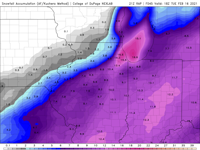
21z RAP
-
easy low-ball.
-
18z GFS bumped NW, and para GFS tick NW.
-
18z RGEM bumping NW.
-
how dare you talk down upon and bash an NWS forecast. they are highly qualified and trained meteorologists, who know what they are doing at all times.
- 963 replies
-
- 11
-

-

-
12z Euro with a bump back SE from 6z run. Ends up very similar to 0z run, which had the initial bump NW.
-
Given the NW shift, ORD is now much more in the game for significant lake effect/enhancement. If ORD were to miss out on the LE, it means noting to the official Chicago snowfall total then.
-
low-ball still.
-
low-ball near the lake.
-
More like the GFS for Ohio.
-
12z UKMET continues the bump NW.
-
Seems fairly likely.
-
It did several runs ago, but definitely kudos to the Para GFS of this holds. .
-
12z Para GFS continued the bump NW trend as well. .
-
You’re golden. Enjoy it. .
-
12z OP GFS bumped NW, but still we’ll SE of other guidance. .
-
lol. .
-
12z RGEM jumped NW as well. .
-
It’s a bigger deal for them down there. .


