Chicago Storm
-
Posts
18,657 -
Joined
-
Last visited
Content Type
Profiles
Blogs
Forums
American Weather
Media Demo
Store
Gallery
Everything posted by Chicago Storm
-

Jan 24-26th Potential Something Part 2
Chicago Storm replied to Chicago Storm's topic in Lakes/Ohio Valley
0z Para GFS . -
Jan 24-26th Potential Something Part 2
Chicago Storm replied to Chicago Storm's topic in Lakes/Ohio Valley
0z OP GFS and 0z para GFS bumped south. OP GFS came in a bit drier, and para GFS a bit wetter. -
Jan 24-26th Potential Something Part 2
Chicago Storm replied to Chicago Storm's topic in Lakes/Ohio Valley
. -
Jan 24-26th Potential Something Part 2
Chicago Storm replied to Chicago Storm's topic in Lakes/Ohio Valley
0z RGEM coming in south and weak. More confluence over the Lakes/Northeast, leads to a much faster shearing wave. -
Jan 24-26th Potential Something Part 2
Chicago Storm replied to Chicago Storm's topic in Lakes/Ohio Valley
In addition, more confluence across the Northeast. -
Jan 24-26th Potential Something Part 2
Chicago Storm replied to Chicago Storm's topic in Lakes/Ohio Valley
More ridging ahead of the ejecting wave, and a bit less confluence in the Lakes this run. -
Jan 24-26th Potential Something Part 2
Chicago Storm replied to Chicago Storm's topic in Lakes/Ohio Valley
Not this run as of yet. -
Jan 24-26th Potential Something Part 2
Chicago Storm replied to Chicago Storm's topic in Lakes/Ohio Valley
0z NAM is coming north out west. -
Jan 24-26th Potential Something Part 2
Chicago Storm replied to Chicago Storm's topic in Lakes/Ohio Valley
Yea, for areas east such as portions of IN/MI/OH that will be affected. However, for areas to the west (IA/N MO) it's locked in. -
Jan 24-26th Potential Something Part 2
Chicago Storm replied to Chicago Storm's topic in Lakes/Ohio Valley
there is nothing to suggest this will underperform. that max area in IA/N MO is primed. -
Jan 24-26th Potential Something Part 2
Chicago Storm replied to Chicago Storm's topic in Lakes/Ohio Valley
. -
Jan 24-26th Potential Something Part 2
Chicago Storm replied to Chicago Storm's topic in Lakes/Ohio Valley
18z Euro bumped back south. . -
Jan 24-26th Potential Something Part 2
Chicago Storm replied to Chicago Storm's topic in Lakes/Ohio Valley
18z GEM bumped north again. -
Jan 24-26th Potential Something Part 2
Chicago Storm replied to Chicago Storm's topic in Lakes/Ohio Valley
18z GEFS Mean . -
Jan 24-26th Potential Something Part 2
Chicago Storm replied to Chicago Storm's topic in Lakes/Ohio Valley
Haven’t looked into it at all, but delta t’s would at least be better than during Mon-Tue. . -
Jan 24-26th Potential Something Part 2
Chicago Storm replied to Chicago Storm's topic in Lakes/Ohio Valley
you’re on the wrong streets. being a meteorologist does not necessarily make you a professional, nor guarantee you’re good at your job. there are plenty of quality mets, and there are plenty of crappy ones that non-degreed people can outperform. some around here have clearly proven it both ways recently. . -
Jan 24-26th Potential Something Part 2
Chicago Storm replied to Chicago Storm's topic in Lakes/Ohio Valley
Little bit further out for the snow that continues out east... . -
Jan 24-26th Potential Something Part 2
Chicago Storm replied to Chicago Storm's topic in Lakes/Ohio Valley
Pointless not to extend it to the eastern side of the CWA now. . -
Jan 24-26th Potential Something Part 2
Chicago Storm replied to Chicago Storm's topic in Lakes/Ohio Valley
probably more like 39 rainer. . -
Jan 24-26th Potential Something Part 2
Chicago Storm replied to Chicago Storm's topic in Lakes/Ohio Valley
It didn’t shear the wave out as quickly. . -
Jan 24-26th Potential Something Part 2
Chicago Storm replied to Chicago Storm's topic in Lakes/Ohio Valley
Measuring is in good hands for this one luckily. -
Jan 24-26th Potential Something Part 2
Chicago Storm replied to Chicago Storm's topic in Lakes/Ohio Valley
you agree, yet you’re the one that’s getting concerned about the smaller scale details. . -
Jan 24-26th Potential Something Part 2
Chicago Storm replied to Chicago Storm's topic in Lakes/Ohio Valley
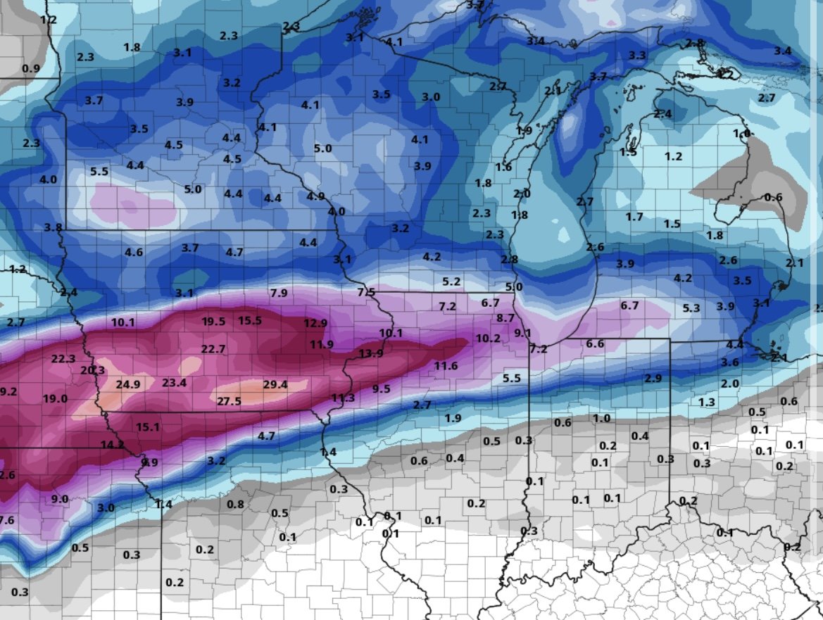
12z GEM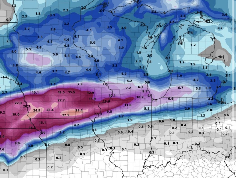
-
Jan 24-26th Potential Something Part 2
Chicago Storm replied to Chicago Storm's topic in Lakes/Ohio Valley
GEM has 30” in parts of IA. . -
Jan 24-26th Potential Something Part 2
Chicago Storm replied to Chicago Storm's topic in Lakes/Ohio Valley
12z GEM bumped north, to the current consensus. .