Chicago Storm
-
Posts
19,240 -
Joined
-
Last visited
Content Type
Profiles
Blogs
Forums
American Weather
Media Demo
Store
Gallery
Everything posted by Chicago Storm
-
Indeed...It’s another day I’ve been watching. Have discussed it a bit with others off the board, as it definitely has some potential.
-
I wouldn’t do it at that distance either...Too conditional and marginal. It’s a high risk - moderate reward setup. .
-
C IL has been recovering fairly well in the wake of early day rain, storms and cloud debris. Meanwhile, IN has been stocked in with scattered showers and cloud debris much of the day. Obviously IN could still very well go later (And probably will in some fashion), but on paper to me the C IL potential is greater given the recovery. .
-
thought you were in best climo. .
-
If you’re gonna go anywhere, C IL would make more sense. That was my original plan, but it’s just a bit too marginal/conditional for the 3 hour drive (Or more). .
-
The first part of this statement says it all. .
-
probably not. .
-
this feels like a spartman thread. a lot of useless maps. .
-
yes, you are.
-

June 20th, 2021 Severe Weather Event
Chicago Storm replied to MazooWeather's topic in Lakes/Ohio Valley
RFD damage was virtually non-existent. Went from no damage to tornado damage very quickly. -
gonna go 0-2 within the past few days. not your season. .
-
i thought there was a drought? .
-
June 20th, 2021 Severe Weather Event
Chicago Storm replied to MazooWeather's topic in Lakes/Ohio Valley
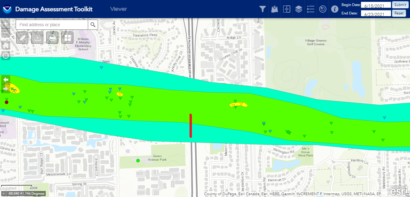
LOT has the damage assessment tool up now. Red line is where I was when it hit.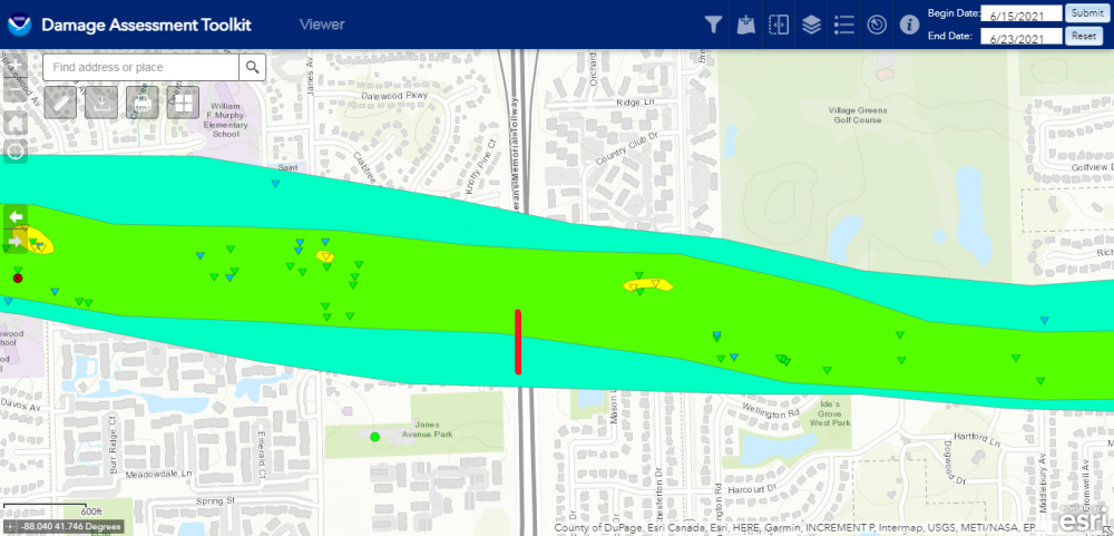
-
should have gotten on the train while you all could. .
-
June 20th, 2021 Severe Weather Event
Chicago Storm replied to MazooWeather's topic in Lakes/Ohio Valley
A few additional videos from today... -
June 20th, 2021 Severe Weather Event
Chicago Storm replied to MazooWeather's topic in Lakes/Ohio Valley
Alright... So, as I mentioned last night I took a hit from the Naperville/Woodridge/Darien tornado as it crossed I-355 in Woodridge. As the line of storms approached, I noticed that couplet was organizing. It was set to cross I-355 less than 10 minutes from where I live, and I knew I had just enough time to get there. So we jumped in the car and 8 minutes later we were hit. Driving south on 355 approaching, there were several power flashes off to the right side, even as we came to a stop. Then it rolled us, throwing debris at the car (Hard to see it a lot in the video due to rain). After the hit, I spent quite a while out in the damage path, on either side of 355. The damage path is a healthy width, but the significant damage was confined to about a 3 home width or so. Some of the most significant damage I’m guessing could be EF-3, thinking of some of the DI off the top of my head.- 236 replies
-
- 17
-

-
June 20th, 2021 Severe Weather Event
Chicago Storm replied to MazooWeather's topic in Lakes/Ohio Valley
I’m alive. More later... . -
June 20th, 2021 Severe Weather Event
Chicago Storm replied to MazooWeather's topic in Lakes/Ohio Valley
Just got hit by a tornado on I-355 in Woodridge. . -
June 20th, 2021 Severe Weather Event
Chicago Storm replied to MazooWeather's topic in Lakes/Ohio Valley
They’re all rotating a lot just aloft. . -
June 20th, 2021 Severe Weather Event
Chicago Storm replied to MazooWeather's topic in Lakes/Ohio Valley
Nice bowing line segment about to push through the metro. A few smaller supercell like structures ahead of the line showing weak rotation at times as well. . -
June 20th, 2021 Severe Weather Event
Chicago Storm replied to MazooWeather's topic in Lakes/Ohio Valley
Re: SPC MD... Seems overzealous in the near term. -
June 20th, 2021 Severe Weather Event
Chicago Storm replied to MazooWeather's topic in Lakes/Ohio Valley
I didn’t even follow my advice. Got off work at 2, got home and haven’t left. 19z ILX sounding has a sizable cap, dry air aloft, among other things. Maybe the MCV will eventually do something in IN/OH, but IL is mostly done for. Attention then turns to the front in IA, but the issue there is the best threat will likely be confined to IA. Modified flow in off the backside of the first waves activity is feeding northwest, so the corridor of max potential out there is likely only in C IA. All in all, no bueno. . -
June 20th, 2021 Severe Weather Event
Chicago Storm replied to MazooWeather's topic in Lakes/Ohio Valley
Could have played both, that's my current plan. I'm off work from ORD at 2. Guessing by then somewhere in the Ottawa-Pontiac-Kankakee area might be in play with the MCV. Will chase around there for a while before hauling west to the IL/IA border. IKK to DVN can be done in 2hrs and 30mins, and with it light out till 9 now, it's doable. -
June 20th, 2021 Severe Weather Event
Chicago Storm replied to MazooWeather's topic in Lakes/Ohio Valley
The NAM has come in and reversed a bit of the bleeding that was happening on guidance last night. Would suggest a quality threat with the MCV from the Chicago metro into SW MI and N IN during the mid afternoon through early tonight. Then it has a sig environment in E IA and NW IL during the evening and into early tonight. The cloud cover and precip shield with the hurricane over IA this morning has been steadily fading, with a good deal of clearing already across MO and C/S IL. Everything seems to be on track for now. -
90 ORD, 91 MDW, 93 RFD and 93 at ex home on today. 13 - RFD 13 - Ex home 9 - ORD 8 - MDW .