Chicago Storm
-
Posts
19,201 -
Joined
-
Last visited
Content Type
Profiles
Blogs
Forums
American Weather
Media Demo
Store
Gallery
Everything posted by Chicago Storm
-

1/24-1/25 Major Winter Storm - S. IL, IN, and OH
Chicago Storm replied to A-L-E-K's topic in Lakes/Ohio Valley
the game likely would have been moved, unfortunately. -
1/24-1/25 Major Winter Storm - S. IL, IN, and OH
Chicago Storm replied to A-L-E-K's topic in Lakes/Ohio Valley
pats/seahawks. -
1/24-1/25 Major Winter Storm - S. IL, IN, and OH
Chicago Storm replied to A-L-E-K's topic in Lakes/Ohio Valley
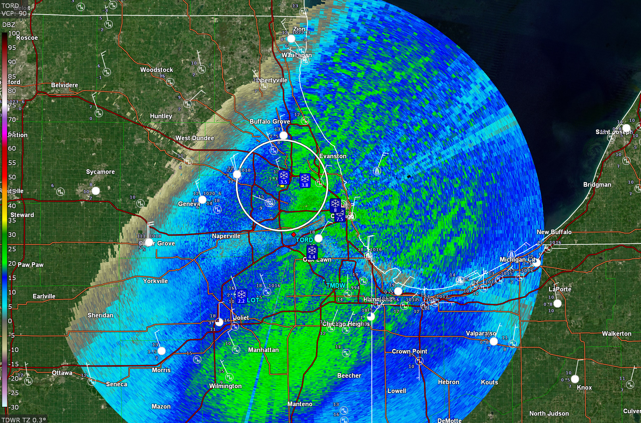
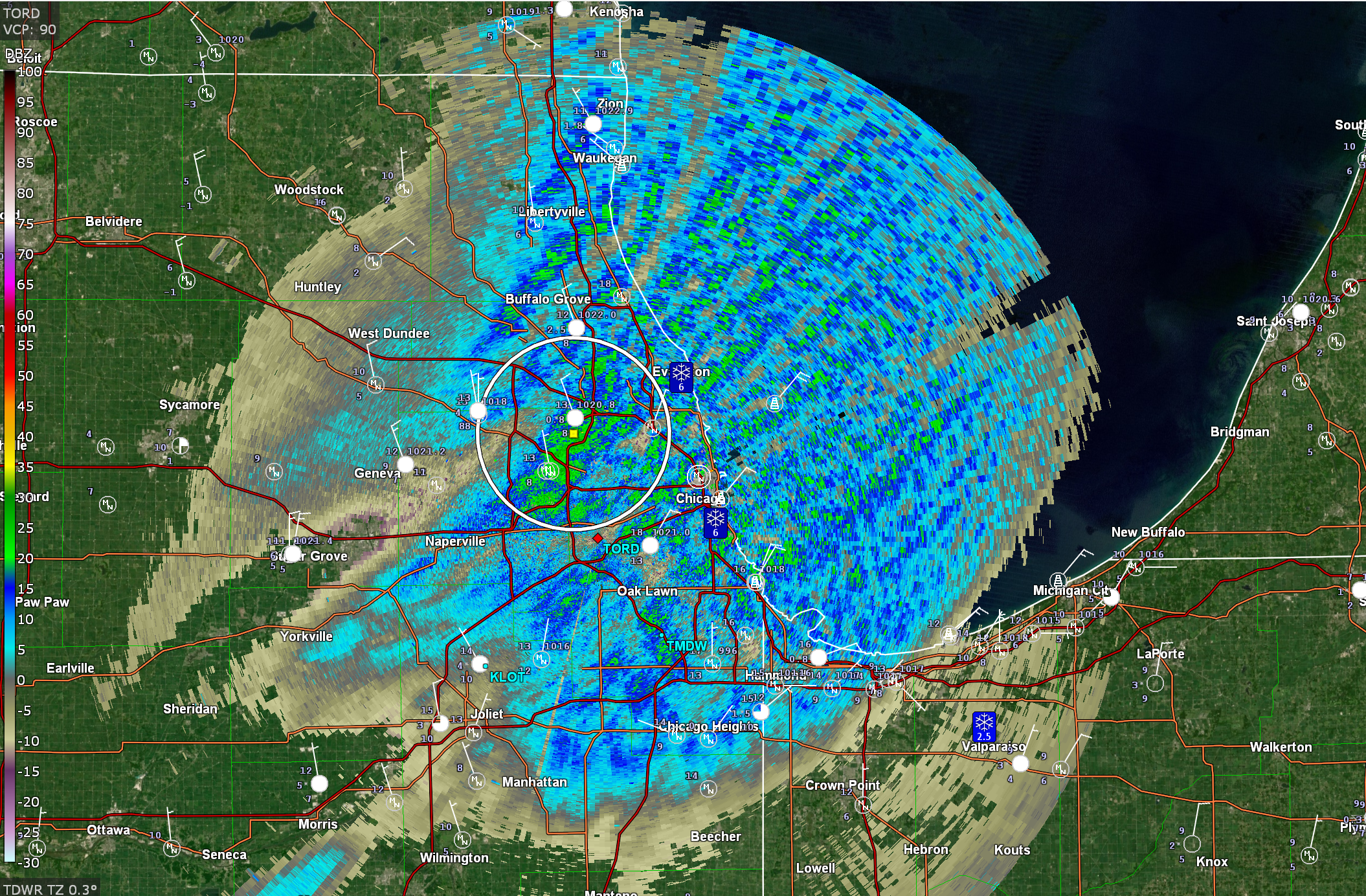
Some synoptic enhancement right now, but that aside, that's a quality shredded multi-band look that we just don't see on this side of the lake very often.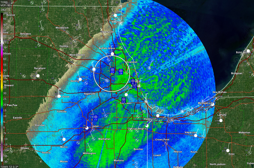
-
1/24-1/25 Major Winter Storm - S. IL, IN, and OH
Chicago Storm replied to A-L-E-K's topic in Lakes/Ohio Valley
METAR KORD 251651Z 34012KT 3/4SM R10L/5000VP6000FT -SN VV015 M11/M13 A3010 RMK AO2 SLP208 SNINCR 1/3 P0000 T11061133 $ -
1/24-1/25 Major Winter Storm - S. IL, IN, and OH
Chicago Storm replied to A-L-E-K's topic in Lakes/Ohio Valley
This could end up being the most widespread-significant nearly pure multi-band LES events that I can remember on this side of the lake...
- 935 replies
-
- 13
-

-

-
1/24-1/25 Major Winter Storm - S. IL, IN, and OH
Chicago Storm replied to A-L-E-K's topic in Lakes/Ohio Valley
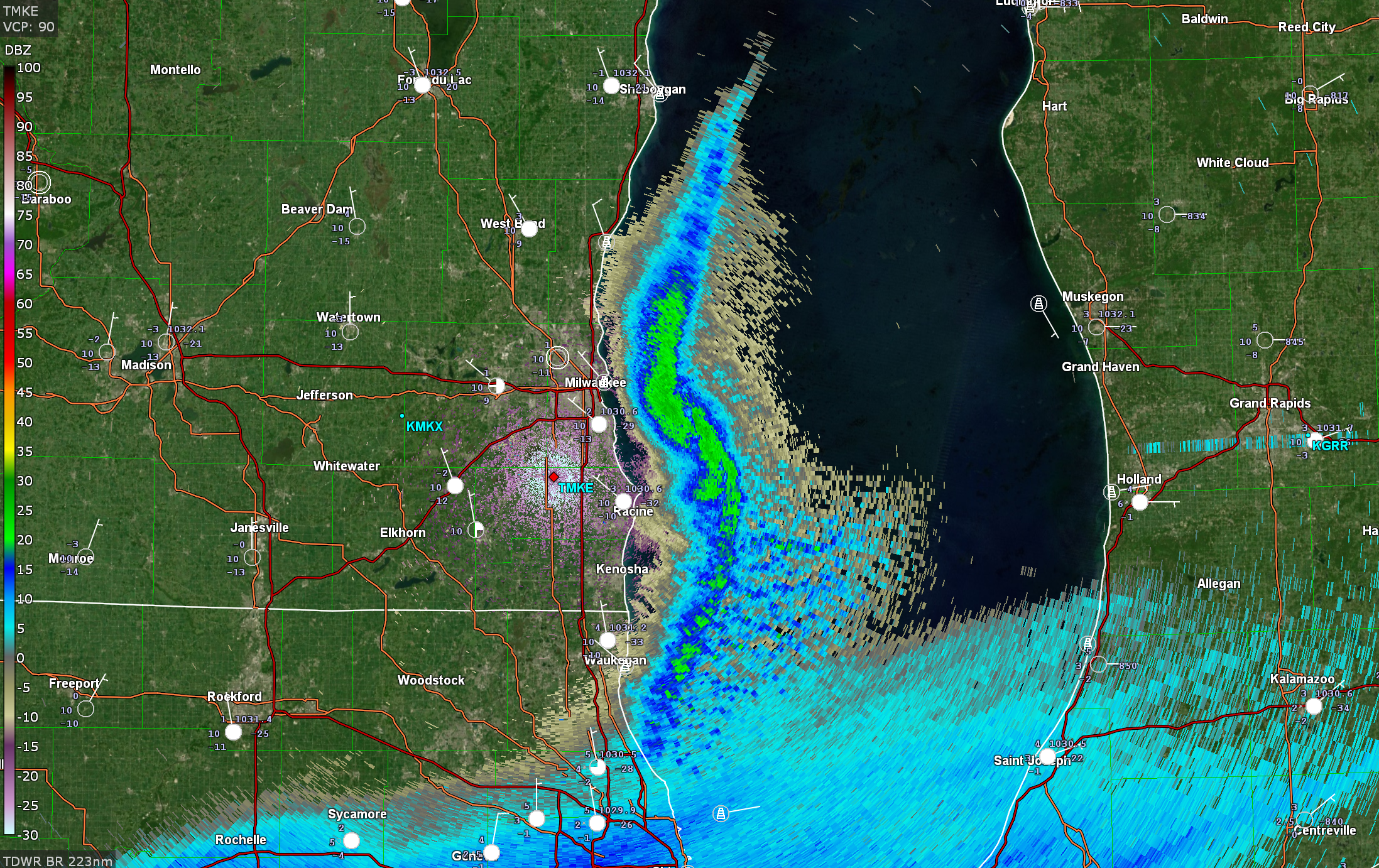
The multiple meso-lows of earlier tonight have sort of morphed into a main one now, which is attempting to back towards MKE.
-
1/24-1/25 Major Winter Storm - S. IL, IN, and OH
Chicago Storm replied to A-L-E-K's topic in Lakes/Ohio Valley
Looks like mixing has gotten further north than anticipated down-state, just south of Carbondale-Harrisburg. -
Low temp of -10 at ORD this morning.
-
1/24-1/25 Major Winter Storm - S. IL, IN, and OH
Chicago Storm replied to A-L-E-K's topic in Lakes/Ohio Valley
Lake enhancement is doing work downtown. Looks like about SN 1/2SM on the EarthCam. -
1/24-1/25 Major Winter Storm - S. IL, IN, and OH
Chicago Storm replied to A-L-E-K's topic in Lakes/Ohio Valley
I do think that it'll move further onshore. The main question more-so is how far onshore it'll move and how long it will take up residence in a particular area. -
1/24-1/25 Major Winter Storm - S. IL, IN, and OH
Chicago Storm replied to A-L-E-K's topic in Lakes/Ohio Valley
Multiple meso-lows out over the over the lake. That southern one is potent.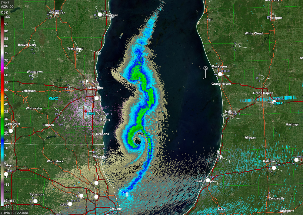
- 935 replies
-
- 12
-

-
-
1/24-1/25 Major Winter Storm - S. IL, IN, and OH
Chicago Storm replied to A-L-E-K's topic in Lakes/Ohio Valley
Lake enhancement is coming onshore in the immediate downtown area currently. -
1/24-1/25 Major Winter Storm - S. IL, IN, and OH
Chicago Storm replied to A-L-E-K's topic in Lakes/Ohio Valley
he is not. -
1/24-1/25 Major Winter Storm - S. IL, IN, and OH
Chicago Storm replied to A-L-E-K's topic in Lakes/Ohio Valley
the hrrr also says no snow till midnight or so. in reality, it's already about to start snowing, albeit light. it's struggling with the saturation progress. -
1/24-1/25 Major Winter Storm - S. IL, IN, and OH
Chicago Storm replied to A-L-E-K's topic in Lakes/Ohio Valley
i'd prefer 97/75 and an evening bow echo, thanks. -
Low temp of -11 at ORD this morning. The daytime high temp was limited to -4, but the actual high for the day was 5 at midnight. The peak wind chill was -36.
-
1/24-1/25 Major Winter Storm - S. IL, IN, and OH
Chicago Storm replied to A-L-E-K's topic in Lakes/Ohio Valley
The whole thing is a shit show, quite honestly. I get what they are doing and why they are doing it. However, your new model system (RRFS/REFS) really should be much better than your old model system (NAM/SREF), which hasn't had an upgrade in many years. -
1/24-1/25 Major Winter Storm - S. IL, IN, and OH
Chicago Storm replied to A-L-E-K's topic in Lakes/Ohio Valley
solid assessment, as always. are you still at cle? -
1/24-1/25 Major Winter Storm - S. IL, IN, and OH
Chicago Storm replied to A-L-E-K's topic in Lakes/Ohio Valley
the run-to-run changes 'under the hood' aloft are fun to watch on any given model. see the nam 12z vs 18z, just as a recent example. really struggling to resolve things. -
1/24-1/25 Major Winter Storm - S. IL, IN, and OH
Chicago Storm replied to A-L-E-K's topic in Lakes/Ohio Valley
i have some bad news. -
1/24-1/25 Major Winter Storm - S. IL, IN, and OH
Chicago Storm replied to A-L-E-K's topic in Lakes/Ohio Valley
that idea is already a bust, since all other guidance caved to the gfs. -
If you could re-experience ONE winter event....
Chicago Storm replied to cyclone77's topic in Lakes/Ohio Valley
I've sat on this one for a while now, trying to decide. The only two options I could come up with were the blizzard of '99 and GHD1. The choice of GHD1 seems easy to me. I feel I'd be able to enjoy it more at this point in life, plus it was more significant in many aspects. -
Winter 2025-26 Medium/Long Range Discussion
Chicago Storm replied to michsnowfreak's topic in Lakes/Ohio Valley
doubtful. not enough snow-cover. -
Winter 2025-26 Medium/Long Range Discussion
Chicago Storm replied to michsnowfreak's topic in Lakes/Ohio Valley
didn't have you turning into beavis on my bingo card. -
where? there’s gonna be a foot of snow downstate. that’s not an east coast pattern.