

Chicago Storm
-
Posts
19,240 -
Joined
-
Last visited
Content Type
Profiles
Blogs
Forums
American Weather
Media Demo
Store
Gallery
Everything posted by Chicago Storm
-
The reason for the change in the NAM is due to how it handles the wave as it ejects out into and through the Plains. The 18z run went with a slightly more amped and tilted wave. Subtle differences, but they matter greatly.
-
.
-
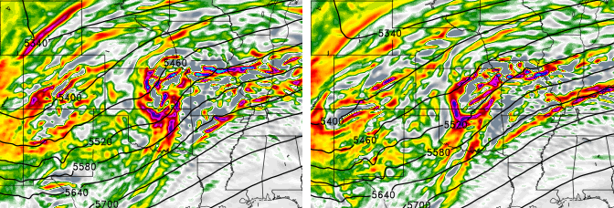
Differences with the HRRR (And RAP) can likely be attributed to how the HRRR (And RAP) handle things across the West. The main wave ejecting is more amped, and maybe slightly negative tilt while ejecting into the Plains… While at the same time, the main through and kicker wave is more neutral tilt. Most other guidance is neutral tilt with ejecting wave and positive tilt with kicker trough/wave. Goes to show that every little bit counts. (Hard to see image, but best I could do). .
-
If you take a look a loft, we’ve seen some noticeable changes the past few days, and you can see why we’re at the point that we are. With placement of the PV lobe in Canada, the ridge is has trended flatter and confluence has increased across the northern Great Lakes into the Northeast. Additionally and the bigger change has been the trough orientation and individual wave/disturbance trajectory/interaction has changed across the West, before and after ejection of the main wave. Much less positive interaction and less phasing as well. (At one point a few days ago, some guidance had multiple waves well phased, with the main wave ejecting into the Plains amped and negative tilt). .
-
This is a Pac moisture driven setup for the cold side. .
-
Drier/weaker trend won’t be denied. .
-
i didn’t make a call. but pretty sure rainer is gonna bust low. .
-
GEM
-
Very much so, was just looking at that actually. Snow rapidly overspread the area by 13-14z and best snows would be over by 2z ...though it would still snow beyond that point.
-
It's really not all that far north. Biggest thing is the very sharp gradient on either side of the axis. There are some counties (Small ones at that) that you go from a DAB to 7" in opposite ends of the given county.
-
HRRR is in the real world in terms of snowfall axis placement. Also hits the LE quite well in NE IL/SE WI.
-
Not this region, but there’s a significant wildfire ongoing in the far northwest suburbs of Denver. It’s being fueled by the drought and high winds. .
-
Makes sense, and would agree the latter option would be the concern.
-
another useless model. .
-
when you know, you know.
-
least surprising thing of the day. .
-
I did come across one just now actually. A jeweler with locations in the suburbs is offering money back on purchases from late Nov/early Dec, if 6”+ falls on NYD. .
-
Didn't know places still did that nonsense, until I saw Walter E Smithe has one going for Feb 13th.
-
By the way, ORD snow measurements will be in the hands of yours truly from 20z Sat - 4z Sun. .
-
def not. he’s just in emotional times, so trying to boost his mental state. .
-
you need any victory you can get these days. my gift to you. .
-
Good to know. Whoever provided the false info before needs to be canned. .
-
It did not. The Euro took an easy run-away victory.
-
Easy toss on the NAM. Also, we’re only 2 days out now. .
-
ricky says it’s time to retire the NAM. .


