

Blue Ridge
-
Posts
1,565 -
Joined
-
Last visited
Content Type
Profiles
Blogs
Forums
American Weather
Media Demo
Store
Gallery
Everything posted by Blue Ridge
-

TN valley heavy rain/flooding week of whenever
Blue Ridge replied to janetjanet998's topic in Tennessee Valley
For those playing along at home, 1 m/s = 2.237 mph. Alternatively, use this handy calculator. Ignoring the high outliers, it looks like Camp Creek is consistently flirting with 40 m/s - nearly 90 mph. (FYI - if that 54 m/s observation is verified, that's ~121 mph.) @Math/Met Thoughts?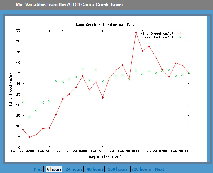
-
TN valley heavy rain/flooding week of whenever
Blue Ridge replied to janetjanet998's topic in Tennessee Valley
The latest from MRX: -
...A TORNADO WARNING REMAINS IN EFFECT UNTIL 830 PM CST FOR SOUTHWESTERN DAVIDSON...NORTHWESTERN WILLIAMSON AND SOUTH CENTRAL CHEATHAM COUNTIES... At 812 PM CST, a severe thunderstorm capable of producing a tornado was located over Pegram, or 14 miles south of Ashland City, moving east at 40 mph. HAZARD...Tornado. SOURCE...Radar indicated rotation. IMPACT...Flying debris will be dangerous to those caught without shelter. Mobile homes will be damaged or destroyed. Damage to roofs, windows, and vehicles will occur. Tree damage is likely. This tornadic thunderstorm will remain over mainly rural areas of southwestern Davidson, northwestern Williamson and south central Cheatham Counties. This includes Interstate 40 between mile markers 182 and 197.
-
The GFS has continually flirted with severe since Jax mentioned it above - less so than the 12z Euro, mercy. Fitting, as we are almost to the 11 year anniversary of the Super Tuesday outbreak.
-
Looks like the GFS has backed off a bit for now. Way too early to tell obviously. <banter>I'm all too happy to throw in the towel on winter early if that would net an active spring, but I won't hold my breath.</banter>
-
It was felt in East Tennessee as well. It was enough to shake the walls much like a strong wind gust.
-
Devastating tornado strikes Joplin, Missouri
Blue Ridge replied to Hoosier's topic in Weather Forecasting and Discussion
I typically lurk the severe weather threads outside of the SE, but I wanted to pop by to say I'm glad JoMo is safe and well. Amazing stories are being told here. I'm certainly bookmarking this thread for future reference.

