Blue Ridge
-
Posts
1,565 -
Joined
-
Last visited
Content Type
Profiles
Blogs
Forums
American Weather
Media Demo
Store
Gallery
Everything posted by Blue Ridge
-
Full disclosure: don't consider myself a Vols fan, though I do watch with interest. Certainly not an apologist. SEC Network's Jordan Rodgers posted on Twitter a great breakdown that more or less proves JG called his own shot on the botched QB sneak. Likely would have been a TD had the play been run as called. He also missed a wide open Jauan Jennings earlier in the game for a sure TD. Had Maurer not been injured, I think the game plays out differently. Bama could say the same about Tua, however. Zebras also got in the way. Absolutely atrocious officiating all night. I think Pruitt/Chaney will do well if given a bit more time. To hear him talk, Pruitt sounds like a dolt, but playcalling and effort have improved greatly throughout the season. Sit Maurer for the rest of the season. Fire JG into the sun. Start Shrout and throw in the wildcat with Jennings or Jordan. The season is already lost, but I see good things coming. If Maurer looks good, QB debate gets interesting next season between him and the Maryland transfer Kasim Hill.
-
and within 240? My god. Sound the alarms.
-
Had a nice shower earlier, even a clap of thunder. Nice bonus on a 30% POP day. Two wildfires made the news this weekend - one in Greene Co. caused by an imbecile burning trash, the other of unknown origin in Carter Co. I fear this is just the beginning should a wetter pattern not soon take hold.
- 179 replies
-
- 1
-

-
- record heat
- transition
- (and 4 more)
-

Tennessee Valley 2019 Fall Speculation/Forecasting
Blue Ridge replied to AMZ8990's topic in Tennessee Valley
Well, that escalated quickly...- 574 replies
-
- 2
-
-
- early winter
- leaves changing
- (and 3 more)
-
Looks like the nasty cell that flared up between Newport and Parrottsville verified its SVR. MRX received a report of 1.5" hail in Greene County.
-
Congrats to Auburn on their amazing run. It's a bit reminiscent of USCe's run to the Final Four in 2017: defeat one of the bluest of blue bloods in the Round of 32; defeat a conference foe in the Elite Eight. USCe is a bit more impressive in that they were a 7 seed; Auburn, meanwhile, is a bit more impressive in that they took down KU, UNC, and UK in consecutive games. UNC was a bit under full strength - Nassir Little was battling the flu and only played 13 min, scoring 4 pts (proof positive he's no Jordan, but he is evidently happy enough with his late first-round draft grade to be a one-and-done). Though he scored 20 and 19 in the first two games, there's no way his ineffectiveness made the difference. Auburn neutered our offense. Carolina loves to run, but they wanted none of that smoke. I feel terrible about Okeke's injury as well. Auburn had to overcome losing a key cog in their offense AND, as you mentioned, unfavorable calls throughout much of the UK game. Speaking of unfavorable calls, I feel like the no-call on the blatant offensive foul late in the UVA-Purdue game has been entirely glossed over. Purdue wins in regulation if that is appropriately whistled.
- 116 replies
-
- 2
-
-
- banter
- chewing the fat
- (and 5 more)
-
Spring/Summer 2019 medium to long range discussion.
Blue Ridge replied to John1122's topic in Tennessee Valley
I saw the elevated DBZ passing over Morristown and the KMRX radar site and wondered just what the hell was happening under it. I don't believe I heard a single rumble of thunder ~30 miles east. -
I broke down and mowed after work yesterday. Despite minimal rainfall during the preceding days, things were still quite damp. That was also the thickest March grass I've ever had the displeasure of cutting. Gonna be a long spring and summer if this keeps up.
- 116 replies
-
- 2
-
-

-
- banter
- chewing the fat
- (and 5 more)
-
Pour one out for @nrgjeff and the Jayhawks. "The Streak" ended with a whimper as Kansas was drubbed by yet another bubblicious Lon Kruger OU team. Credit where it's due - Self has done a great job after losing Azubuike to injury, Vick to a personal matter, De Sousa to the feds, and Grimes, a McDonald's All American, to the freshman yips.
- 116 replies
-
- 1
-

-
- banter
- chewing the fat
- (and 5 more)
-
TN valley heavy rain/flooding week of whenever
Blue Ridge replied to janetjanet998's topic in Tennessee Valley
It's lol-worthy at this point.
-
TN valley heavy rain/flooding week of whenever
Blue Ridge replied to janetjanet998's topic in Tennessee Valley
That's...not good. -
Spring/Summer 2019 medium to long range discussion.
Blue Ridge replied to John1122's topic in Tennessee Valley
That might be the strangest system I've seen the GFS spit out within 168 hrs in a long time. It's basically a 12-18 hour burst of moderate to heavy snow from a strange setup: 132: over ATL; 1050 mb H at the Montana/Alberta/Saskatchewan border 138: over CAE; 1052 mb H just SE of previous position 144: now approx. 100 mi south, near HHI; 1052 mb H in same position 150: off Hatteras, 1004 mb.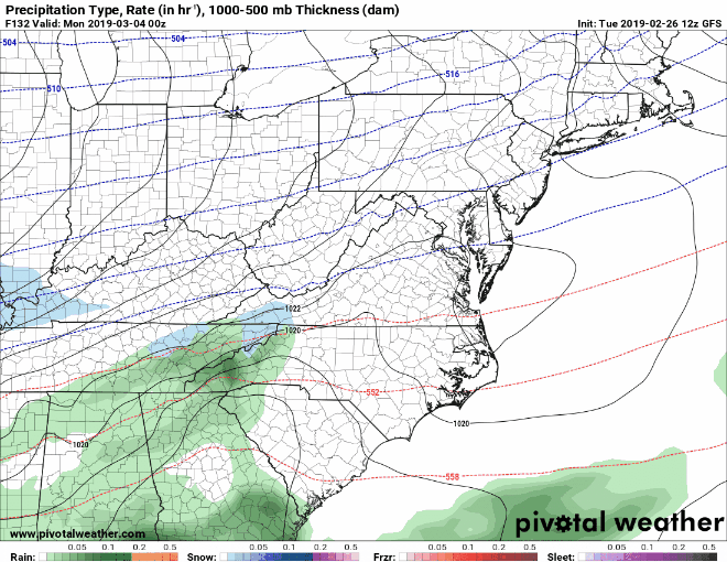
-
Yeah, no. Doesn’t work like that, buddy. I experienced the same issue as @Windspeed. A similar issue was previously noted on AmWx some time ago. Sometimes it’s the result of malicious script injected w/o the webmaster’s knowledge; other times, an ad can be the culprit. Perhaps don’t be quite so abrasive in the future.
-
TN valley heavy rain/flooding week of whenever
Blue Ridge replied to janetjanet998's topic in Tennessee Valley
Darwinism at work... In other news, we took a long drive around rural Washington and Greene Counties. Limestone Creek is doing a number on north and west sections of Washington Co. I’ll post pics in a bit. -
TN valley heavy rain/flooding week of whenever
Blue Ridge replied to janetjanet998's topic in Tennessee Valley
Noticed the same thing earlier wrt FFWs. In fact, Knox Co does not show a FFW despite the PDS Warning in place. -
TN valley heavy rain/flooding week of whenever
Blue Ridge replied to janetjanet998's topic in Tennessee Valley
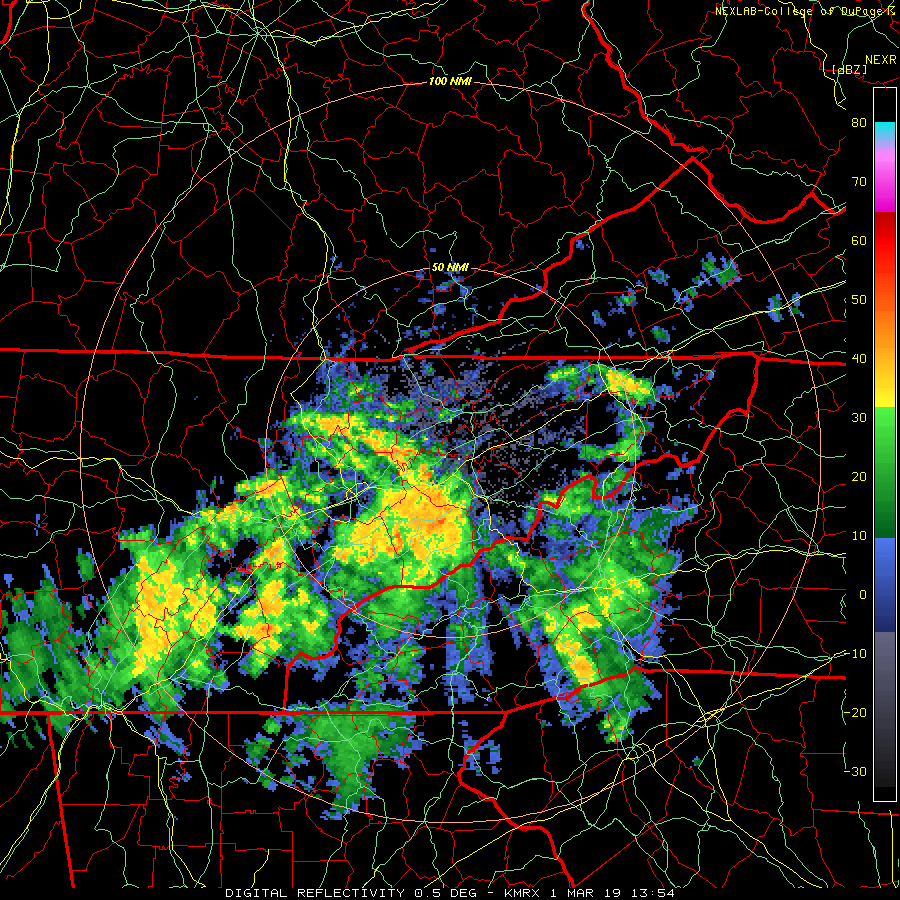
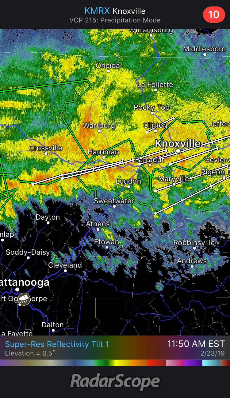
If anything, this may have just a bit of wiggle room to move slightly north and still train directly over Knoxville proper. TYS is going to be oh so close. -
TN valley heavy rain/flooding week of whenever
Blue Ridge replied to janetjanet998's topic in Tennessee Valley
The train is arriving, and I’ll let the storm tracks tell the story. Stay safe, Knoxville friends.
-
TN valley heavy rain/flooding week of whenever
Blue Ridge replied to janetjanet998's topic in Tennessee Valley
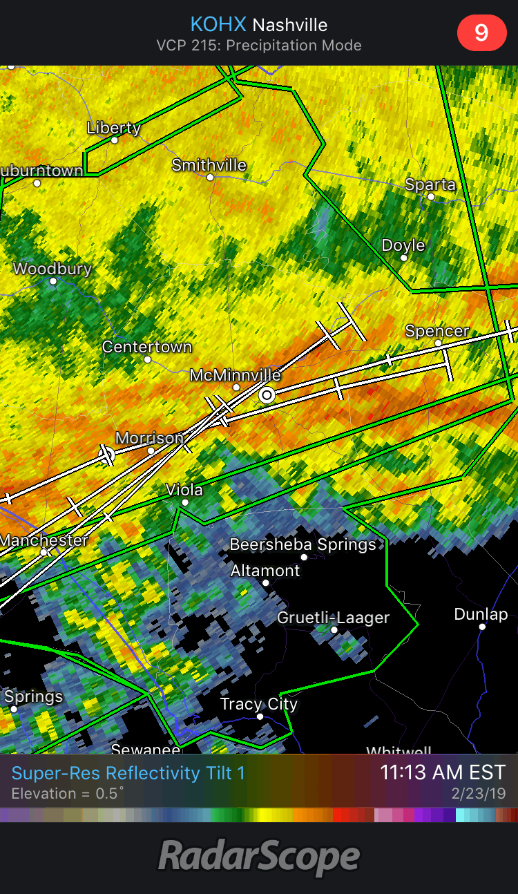
It's going to be a photo finish. Storm tracks on KOHX are also showing slightly more ENE than NE. Watch the training cells move just south of McMinnville. From a hobbyist standpoint, this is fascinating to watch. Meanwhile, the stream in my front yard is slowly beginning to grow into a pond.
-
TN valley heavy rain/flooding week of whenever
Blue Ridge replied to janetjanet998's topic in Tennessee Valley
Easy, dude. @janetjanet998 has been instrumental in flood coverage since this risk first presented itself. Also, we don't "stick to areas" here. The warning you referred to is an areal flood warning. Not the same as a Flash Flood Warning, and certainly not given the same priority. FFWs trigger EAS. -
TN valley heavy rain/flooding week of whenever
Blue Ridge replied to janetjanet998's topic in Tennessee Valley
Two notes, FWIW. 1) There appears to be westerly forcing pushing some of the training cells in middle TN more eastward. This is visible on KHTX. Watch the push around the 50nmi band. Pure conjecture without the aid of a sounding: flow aloft may be more from the west than south, pushing the higher-topped convection east while flow in the lower levels pushes more north. Just a thought. https://weather.cod.edu/satrad/nexrad/index.php?type=HTX-N0Q-0-6 2) Not sure I see much opportunity for clearing across the moderate risk area. That said, that's some nice convection moving into the Arklatex... https://weather.cod.edu/satrad/exper/?parms=regional-southeast-truecolor-24-1-100-1&checked=map&colorbar=undefined -
TN valley heavy rain/flooding week of whenever
Blue Ridge replied to janetjanet998's topic in Tennessee Valley
Can't say I've seen an area go from no FFW to a PDS Flash Flood Emergency in one fell swoop. -
TN valley heavy rain/flooding week of whenever
Blue Ridge replied to janetjanet998's topic in Tennessee Valley
...FLASH FLOOD EMERGENCY FOR KNOXVILLE TENNESSEE AND GREATER KNOX COUNTY... The National Weather Service in Morristown has issued a * Flash Flood Warning for... Knox County in east Tennessee... * Until 130 PM EST. * At 1036 AM EST, emergency management reported heavy rain across the warned area. Up to 3 inches of rain have already fallen over the last 3 to 4 hours with an additional 1 to 2 inches possible over the next 2 hours. Flash flooding is already occurring. This is a FLASH FLOOD EMERGENCY for Knoxville. This is a PARTICULARLY DANGEROUS SITUATION. SEEK HIGHER GROUND NOW! -
TN valley heavy rain/flooding week of whenever
Blue Ridge replied to janetjanet998's topic in Tennessee Valley
After missing out on all but drizzle yesterday, I woke up to 1.63" and a rushing stream in my front yard. I don't so much as have a ditch line. -
TN valley heavy rain/flooding week of whenever
Blue Ridge replied to janetjanet998's topic in Tennessee Valley
PRELIMINARY LOCAL STORM REPORT...SUMMARY NATIONAL WEATHER SERVICE MORRISTOWN TN 346 PM EST WED FEB 20 2019 ..TIME... ...EVENT... ...CITY LOCATION... ...LAT.LON... ..DATE... ....MAG.... ..COUNTY LOCATION..ST.. ...SOURCE.... ..REMARKS.. 0700 AM NON-TSTM WND GST COVE MOUNTAIN 35.71N 83.59W 02/20/2019 M87 MPH SEVIER TN MESONET 0630 AM NON-TSTM WND GST CAMP CREEK 36.09N 82.77W 02/20/2019 M81 MPH GREENE TN MESONET CORRECTS PREVIOUS NON-TSTM WND GST REPORT FROM CAMP CREEK. MEASURED GUST AT THE NOAA/ATDD TOWER. EARLIER REPORTED GUST WAS ERRONEOUS. AFTER QUALITY CONTROL OF THE RAW DATA 81 MPH WAS CONFIRMED TO BE THE CORRECT WIND SPEED. 0659 AM NON-TSTM WND GST 4 SE CEDAR CREEK 35.98N 82.84W 02/20/2019 M51 MPH GREENE TN MESONET MESONET STATION PGVT1, NOLICHUCKY (4 SE CEDAR CREEK). 0327 AM NON-TSTM WND GST 1 SE SIGNAL MOUNTAIN 35.12N 85.33W 02/20/2019 M49 MPH HAMILTON TN MESONET MESONET STATION C9567, SIGNAL MOUNTAIN. 1000 AM NON-TSTM WND GST 4 WSW ROAN MOUNTAIN 36.17N 82.15W 02/20/2019 M47 MPH CARTER TN MESONET MESONET STATION D5724, 4 WSW ROAN MOUNTAIN. 0106 AM NON-TSTM WND GST 5 SE POWELLS CROSSROADS 35.13N 85.43W 02/20/2019 M43 MPH MARION TN MESONET MESONET STATION PCFT1, PRENTICE COOPER SF. 0905 AM NON-TSTM WND GST 1 WNW UNICOI 36.20N 82.37W 02/20/2019 M43 MPH UNICOI TN MESONET MESONET STATION UNIT1, WATAUGA (1 WNW UNICOI). -
TN valley heavy rain/flooding week of whenever
Blue Ridge replied to janetjanet998's topic in Tennessee Valley
Just hit ~110 again. I believe it may be legit. If so, that's incredible.