Blue Ridge
-
Posts
1,565 -
Joined
-
Last visited
Content Type
Profiles
Blogs
Forums
American Weather
Media Demo
Store
Gallery
Everything posted by Blue Ridge
-
The corresponding watch doesn’t provide much comfort, either. WT 0045 PDS PROBABILITY TABLE: PROB OF 2 OR MORE TORNADOES : >95% PROB OF 1 OR MORE STRONG /EF2-EF5/ TORNADOES : >95% PROB OF 10 OR MORE SEVERE WIND EVENTS : 70% PROB OF 1 OR MORE WIND EVENTS >= 65 KNOTS : 60% PROB OF 10 OR MORE SEVERE HAIL EVENTS : 70% PROB OF 1 OR MORE HAIL EVENTS >= 2 INCHES : 60% PROB OF 6 OR MORE COMBINED SEVERE HAIL/WIND EVENTS : >95% && ATTRIBUTE TABLE: MAX HAIL /INCHES/ : 2.5 MAX WIND GUSTS SURFACE /KNOTS/ : 65 MAX TOPS /X 100 FEET/ : 500 MEAN STORM MOTION VECTOR /DEGREES AND KNOTS/ : 24040 PARTICULARLY DANGEROUS SITUATION : YES
-
Death band delivers. Absolutely ripping.
-
HKY’s sleet line is accurate. We’re 75% IP, 25% flakes just SW of downtown Holly Swings.
-
15 dBZ = fat (nickel to quarter) flakes. No DGZ issues (yet) today!
-
Returns increasing to the south and southwest of Wake. CC suggests transition zone along a line from Pinehurst to Dunn.
-

February 19-20 Major Winter Storm Threat
Blue Ridge replied to NorthHillsWx's topic in Southeastern States
yes, but have you considered WRAL bad? -
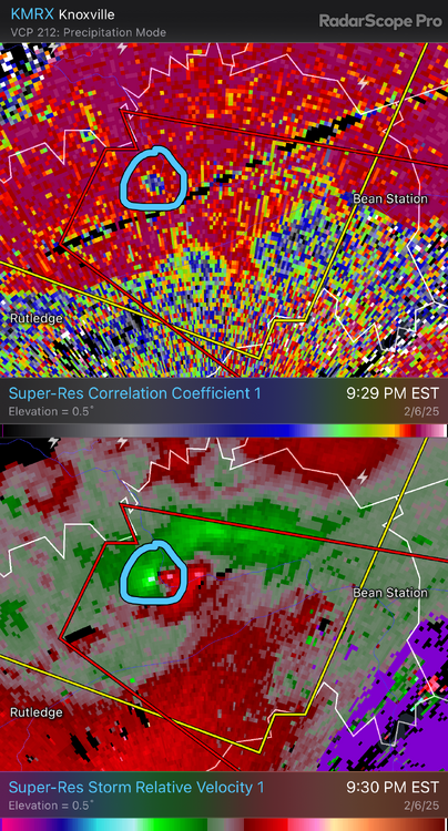
TOR for Grainger, Hamblen, and Hawkins has the “observed” tag as of 9:33 pm. Looking a few frames back, you can see why. Definitely a touchdown.
-
CLT was a hundred miles from so much as a stray dandruff flake ~24 hrs out. This was a significant NW shift over a very short window. Carolina Crusher II was never on the table. Even the rosiest model output from drunk uncle 18Z NAM was several standard deviations away.
-
What the hell is this cringefest distracting me from my TWELVE flurries?
-
Flurries in Southern Pines, per Chick Jacobs’s feed. Nothing directly overhead on KRAX.
-
…both? It can be both.
-
I think WRAL bears the brunt of the memeing because they long had the TV met synonymous with Raleigh (Fishel) and have long been a market leader. The “Mike Maze says bleep your snow” thing is truly a joke. I enjoy Mike and the team at WRAL, and I don’t envy the job of any public facing met. My life also doesn’t hinge on each forecast update, which probably helps.
-
A tradition like no other. Mike Maze says “**** your snow.”
-
1/10-11 super awesome winter SE OBS thread
Blue Ridge replied to strongwxnc's topic in Southeastern States
30 dbz returns rolling in resulting in the fattest and wettest of the night! Rain drops, that is. -
1/10-11 super awesome winter SE OBS thread
Blue Ridge replied to strongwxnc's topic in Southeastern States
50/50 IP/ZR mix now. Elevated surfaces have a nice glaze. -
1/10-11 super awesome winter SE OBS thread
Blue Ridge replied to strongwxnc's topic in Southeastern States
Mesoscale Discussion 0033 NWS Storm Prediction Center Norman OK 0534 PM CST Fri Jan 10 2025 Areas affected...portions of central and northern South Carolina into central North Carolina Concerning...Freezing rain Valid 102334Z - 110330Z SUMMARY...Heavier freezing rain rates will continue to spread into northern South Carolina into central North Carolina through the evening hours. .06 inch/3 hour rates are expected. DISCUSSION...Low-level warm-air advection continues to intensify across GA into SC ahead of an approaching mid-level trough. While a wintry mix is ongoing across central portions of NC into SC, the continued WAA in the 850-700 mb layer will encourage freezing rain to become the predominant mode of wintry precipitation into the evening hours, as evident via 22Z RAP forecast soundings and 23Z mesoanalysis. Surface observations depict an increase in freezing rain already underway across northern SC into central NC, with heavier ice accretion rates likely this evening. Furthermore, high-resolution model guidance also shows a high likelihood of .06 in/3 h ice accretion rates, especially in the 00-06Z time frame. ..Squitieri.. 01/10/2025 -
My only issue lies with the giant radar hole in WNC, and I routinely remind elected representatives of that fact haha. As for the GSP metro, I love the Upstate - no shade from me whatsoever. However, I do get how GSP seems like an odd fit to be responsible for both Asheville and Charlotte. Ultimately doesn’t mean shite, though, and GSP does a damn good job even with a gaping radar hole in their CWA. On topic: quickly down to 31°F with a lull in precip. The end of that band looked very drizzly/misty…
-
When Asheville and Charlotte WFO duties were merged into Greer, it was a town of <15K. So, yes, an obscure location in comparison to Asheville and/or Charlotte.
-
1/10-11 super awesome winter SE OBS thread
Blue Ridge replied to strongwxnc's topic in Southeastern States
First flakes just SW of downtown Holly Swings -
1/10-11 super awesome winter SE OBS thread
Blue Ridge replied to strongwxnc's topic in Southeastern States
Based on several mPing reports, returns currently entering southern Wake began as sleet in N Harnett and S Johnston. -
IMBY post: HRRR has been consistent in showing the sharp gradient running through my neck of S Wake. Will be interesting to watch unfold if nothing else.
-
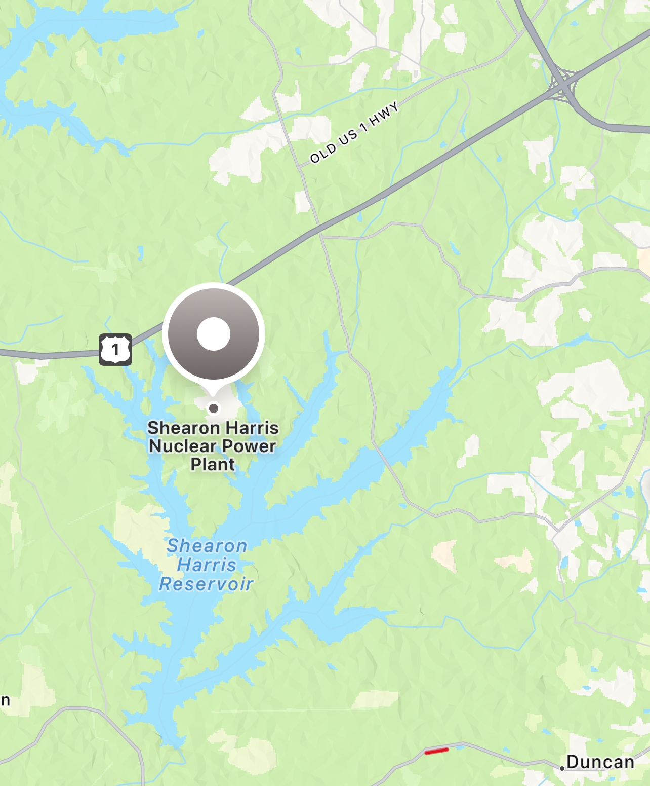
General rule of thumb: mixing/outright ZR is always on the table in Wake, especially south and East. Depending on track, US 1 and/or US 64 are good landmarks for this. edit: that said, even a full ZR storm won’t equate 1:1 to total QPF. Start with total QPF, cut in half, and that’s a reasonable “worst outcome” benchmark.
-
SRQ is still transmitting altimeter data, but nothing else. https://mesowest.utah.edu/cgi-bin/droman/meso_base_dyn.cgi?stn=KSRQ&unit=0&timetype=LOCAL
-
>110 MPH over Anna Maria and moving into Bradenton says you’re wrong