

LibertyBell
-
Posts
39,562 -
Joined
Content Type
Profiles
Blogs
Forums
American Weather
Media Demo
Store
Gallery
Posts posted by LibertyBell
-
-
Just now, Sundog said:
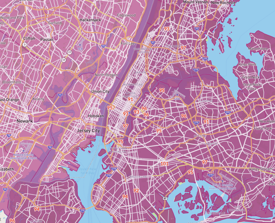
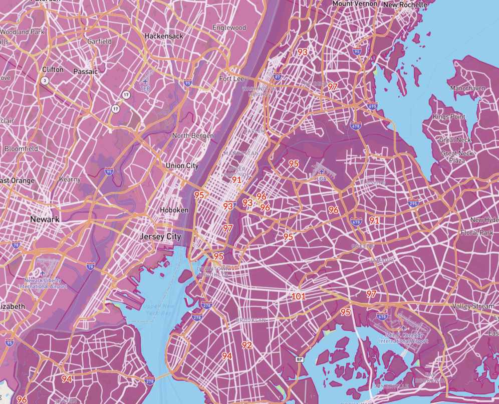
All the 100s ambient stations are in the southern half of Queens
Just reached 102 on my north side sensor and 99 on my west side sensor !!
-
13 minutes ago, jm1220 said:
Southern Nassau away from the barrier islands looks like between 97-101.
yup a due northerly wind
one of my sensors is at 98, the other one at 101 lol
the one at 98 is in the shade near a bush the one at 101 is on the north side of my house just under the roof.
-
1 minute ago, TWCCraig said:
96/69
Sea breeze showing up on the immediate south shore. Slowly crawling, hope it stalls there
barrier islands?
still due north wind here
-
10 minutes ago, SnowGoose69 said:
I think they begin turning 1730-18Z out of the WSW. The Euro seems to have the sea breeze placement closest so far so the high might be in the next 60 minutes
It's due north right now at 11 mph gusting to 20
I hit 101 on my north side sensor, but that is just under the roof so I don't use it a lot.
-
3 minutes ago, SnowGoose69 said:
JFK/EWR gusting 15ks now, thats how you get those 100s, even LGA needs to start going 280-290 G18 to have a chance
WNW wind here, do you think the high temperature at JFK can even be after 2 PM if these strong winds continue?
-
33 minutes ago, SACRUS said:
If it stays cloudy that E/ENE flow will do it, just like last week when we had 3-4 days of 60s low 70s.
after Wednesday no sun until Sunday
-
 1
1
-
-
4 minutes ago, SnowGoose69 said:
I think almost all the convection tomorrow is to the W-SW
it could hit 100 again tomorrow with a WNW wind
-
48 minutes ago, dWave said:
Hot city before noon
wow where is that 101? Ozone Park?
-
2 minutes ago, Sundog said:
There are a few ambient stations now showing 100 in south Queens
I'm jealous!!
-
24 minutes ago, jm1220 said:
Seabreeze might be starting- Long Beach down to 90-91 and Fire Island upper 80s.
It's going to stay on the barrier islands for a few hours, the hourlies say my high temperature will be at 2 PM.
Up to 98 here now.
-
5 minutes ago, Sundog said:
JFK seems stuck at 97 despite the wind still being NW down there
I've hit 98 already so let's see what they show for next hour.
-
9 minutes ago, bluewave said:
The mesonet sites had to find spots which would allow weather stations to be set up. There is a park on the south side of Merrick road at the Wantagh site which had the open land. Plus it’s right next to the old Wantagh COOP which registered the 107° reading back in 2010.
Let's see how accurate these hourly forecasts are. It has the highest temperature for me at 2 PM (I assume the sea breeze comes in after that.) For Glen Cove it has the highest temperature at 5 PM.
Right now the wind is NNW
What's going to keep it from hitting 100 again tomorrow? I see a forecast for mostly sunny skies and a WNW wind.
-
1 minute ago, Sundog said:
Central Park and LGA the cool spots at 91 degrees at the ~11AM update.
both have rivers to their west
-
Just now, SnowGoose69 said:
I don't think NYC hits 100 at this point, LGA it may come down to if they can get more of a shift to the WNW
JFK might before noon
-
1 minute ago, donsutherland1 said:
Atlantic City, JFK Airport, Newark, Norwood, and Wilmington, DE have all reached 96° so far. The East remains on track for multiple 100° highs. JFK could see its first such high in June.
97 at JFK now Don
-
11 minutes ago, bluewave said:
Yeah, this is how Mineola and Wantagh got to 108° and 107° back in July 2010. Downslope flow off the moraine which created compressional warming just on the Inland side of the sea breeze front. The zone this afternoon where the downslope meets the sea breeze will probably go 102° to 104° with maybe a 105° max in the warmest spots from Queens and Brooklyn into Nassau.
Monthly Data for July 2010 for New York
Click column heading to sort ascending, click again to sort descending.MINEOLA COOP 108 WANTAGH CEDAR CREEK COOP 107 LAGUARDIA AIRPORT WBAN 103 NY CITY CENTRAL PARK WBAN 103 WEST POINT COOP 103 RHINEBECK 4SE COOP 103 SHIRLEY BROOKHAVEN AIRPORT WBAN 103 New York-LGA Area ThreadEx 103 New York-Central Park Area ThreadEx 103 FARMINGDALE REPUBLIC AP WBAN 102 DOBBS FERRY-ARDSLEY COOP 102 POUGHKEEPSIE/HUDSON VALLEY REGIONAL AIRPORT WBAN 102 WESTCHESTER CO AP WBAN 102 Poughkeepsie Area ThreadEx 102 STONYKILL NEW YORK RAWS 102 ISLIP-LI MACARTHUR AP WBAN 101 ROSENDALE 2 E COOP 101 BLOOMINGBURG 2 SW COOP 101 JFK INTERNATIONAL AIRPORT WBAN 101 I'm on the south shore but not a good match for Wantagh, I'm 5-10 hotter than them. Why did they put it out there instead of in Valley Stream?
-
2 minutes ago, Sundog said:
Meanwhile JFK is up to 97 on the rapid refresh
The June monthly record is in sight!!
-
1 minute ago, Sundog said:
Meanwhile JFK is up to 97 on the rapid refresh
MATCH !!!
-
19 minutes ago, bluewave said:
I am hoping they can manage the power demands on the system later to avoid anything more than some scattered outages or brown outs. Running 24hrs uninterrupted with the heat index over 90° is impressive. So usage should really spike this afternoon.
now 97 here
-
Just now, Cfa said:
Up to 98 now, ahead of yesterday at this time, today’s low of 72 was cooler than yesterday’s, so it’s interesting that today is already hotter.
Don’t think I’ve ever seen 100 degree conditions after a low in the low 70’s.
yes it's drier today with very blue skies so temperatures will rise quicker
-
30 minutes ago, donsutherland1 said:
As of 9:30, many areas have reached or exceeded 90°. Those areas include Atlantic City, Boston, Islip, New York City-JFK Airport, Newark, Philadelphia, and Providence. Elsewhere, Frankfort, IN had a dewpoint of 82°.95 here heat index 104
-
1 minute ago, Sundog said:
92s in northern Queens, 96s and one 97 popping up in southern Queens.
3K NAM has a sea breeze for the south shore areas and a few miles inland, I am not sure that will be accurate, it has northern Queens and Nassau as hotter for afternoon highs than the southern halves.
hopefully 100 before any sea breeze
95 here now heat index 104
-
Just now, bluewave said:
Yeah, you can see the exact spot when you open the map in the layers tab.
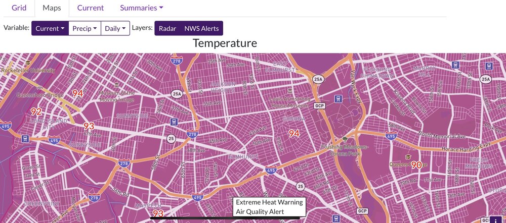
omg it's 95 here now heat index 104
-
4 minutes ago, bluewave said:
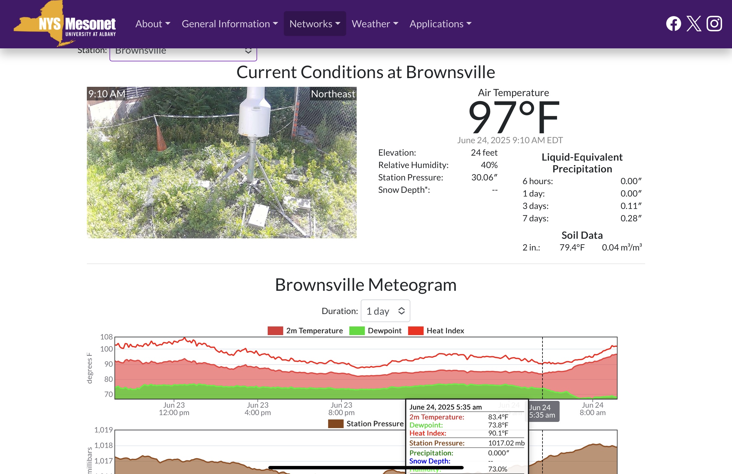
Brownsville, Brooklyn already 97° after a low of 83°.

what kind of equipment do they use, is it NWS certified?

Newark (interiors of NJ/se NYS/CT) Sun-Wed June 22-25 possibly hottest 3-4 day period this year (2025) with 2-4 100F+ days, possibly hottest June daily. NYC probably one 100 deg. HI exceeds 105 interior M-T June 23-24.
in New York City Metro
Posted
I'm pulling for it, I think we won't get the sea breeze here until after 2 pm.