

weatherextreme
-
Posts
540 -
Joined
-
Last visited
Content Type
Profiles
Blogs
Forums
American Weather
Media Demo
Store
Gallery
Everything posted by weatherextreme
-
Severe Weather 3-30-23 and 3-31-23
weatherextreme replied to cheese007's topic in Central/Western States
https://www.localmemphis.com/watch -
Severe Weather 3-30-23 and 3-31-23
weatherextreme replied to cheese007's topic in Central/Western States
Clipped footage https://clips.twitch.tv/HilariousInnocentOrangeFrankerZ-DK7WjIGxf8dnxWgL Some metal object in the middle of the road now (from the live stream) -
Severe Weather 3-30-23 and 3-31-23
weatherextreme replied to cheese007's topic in Central/Western States
Tornado confirmed on stream from the chaser https://www.twitch.tv/stormchaserirl -
Severe Weather 3-30-23 and 3-31-23
weatherextreme replied to cheese007's topic in Central/Western States
This was just posted https://youtu.be/tZyta93AEp8 He's on the Iowa storm Think he has the tornado warned storm -
Severe Weather 3-30-23 and 3-31-23
weatherextreme replied to cheese007's topic in Central/Western States
Looks like Brandon Clement has something https://livestormchasing.com/chasers/Brandon.Clement -
Severe Weather 3-30-23 and 3-31-23
weatherextreme replied to cheese007's topic in Central/Western States
Brad Arnold has/had a lowering on his stream (Per Ryan Hall) -
Severe Weather 3-30-23 and 3-31-23
weatherextreme replied to cheese007's topic in Central/Western States
https://www.youtube.com/watch?v=CNHQQ2BnEeQ Brad Arnold's stream -
Severe Weather 3-30-23 and 3-31-23
weatherextreme replied to cheese007's topic in Central/Western States
New tornado warning for Little rock -
Severe Weather 3-30-23 and 3-31-23
weatherextreme replied to cheese007's topic in Central/Western States
https://livestormchasing.com/chasers/brett.adair Brett has something on his stream -
Severe Weather 3-30-23 and 3-31-23
weatherextreme replied to cheese007's topic in Central/Western States
This guy covering the outbreak as well https://www.twitch.tv/agendafreetv and https://www.twitch.tv/stormchaserirl -
Severe Weather 3-30-23 and 3-31-23
weatherextreme replied to cheese007's topic in Central/Western States
-
Severe Weather 3-30-23 and 3-31-23
weatherextreme replied to cheese007's topic in Central/Western States
Tornado prob increased with slightly larger area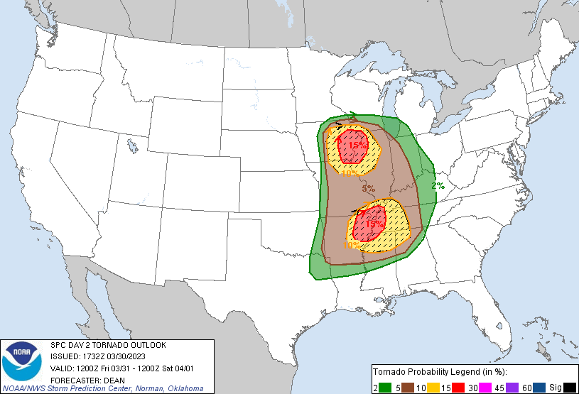
-
Severe Weather 3-30-23 and 3-31-23
weatherextreme replied to cheese007's topic in Central/Western States
Thursday downgraded -
Severe Weather 3-30-23 and 3-31-23
weatherextreme replied to cheese007's topic in Central/Western States
-
Severe Weather 3-23-23 through 3-26-23
weatherextreme replied to cheese007's topic in Central/Western States
Reed confirmed Tornado on stream -
Severe Weather 3-23-23 through 3-26-23
weatherextreme replied to cheese007's topic in Central/Western States
11:30 update -
Severe Weather 3-23-23 through 3-26-23
weatherextreme replied to cheese007's topic in Central/Western States
Loos like more severe for MS and other surrounding locations (Maybe we should extend this thread for this new threat?)
-
Severe Weather 3-23-23 through 3-26-23
weatherextreme replied to cheese007's topic in Central/Western States
Here's the latest from Reed https://www.facebook.com/reedtimmer2.0/ https://www.facebook.com/watch/?v=1239876320289149 -
Severe Weather 3-23-23 through 3-26-23
weatherextreme replied to cheese007's topic in Central/Western States
-
Severe Weather 3-23-23 through 3-26-23
weatherextreme replied to cheese007's topic in Central/Western States
https://www.twitch.tv/agendafreetv Major Tornado Damage in Rolling Fork, Mississippi - LIVE Breaking News Coverage -
Severe Weather 3-23-23 through 3-26-23
weatherextreme replied to cheese007's topic in Central/Western States
Looks like he was cut off abruptly. They are saying something might have happened to Reed. (Not sure what happened) -
Severe Weather 3-23-23 through 3-26-23
weatherextreme replied to cheese007's topic in Central/Western States
https://www.spc.noaa.gov/products/md/md0329.html Mesoscale Discussion 0329 NWS Storm Prediction Center Norman OK 0824 PM CDT Fri Mar 24 2023 Areas affected...North-central MS Concerning...Tornado Watch 76... Valid 250124Z - 250215Z CORRECTED FOR ERROR IN SPATIAL DELINEATION The severe weather threat for Tornado Watch 76 continues. SUMMARY...An intense tornado (EF3+) is likely ongoing with a supercell tracking northeastward across western Sharkley County MS, and this storm should persist for the next 30-60 min. DISCUSSION...Latest radar data shows an organized cyclonic supercell tracking northeastward across western Sharkley County MS, with a VROT above 70 kt and well-defined TDS up to 13k ft -- indicative of an intense tornado (EF3+) given the parameter space (STP of 4). The downstream environment features a large, clockwise-curved hodograph per DGX VWP (around 430 m2/s2 0-1 km SRH) amid rich boundary-layer moisture. This will support the maintenance of this intense supercell toward the northeast for the next 30-60 min. ..Weinman.. 03/25/2023 ...Please see www.spc.noaa.gov for graphic product... -
Severe Weather 3-23-23 through 3-26-23
weatherextreme replied to cheese007's topic in Central/Western States
This was posted on another forum. Looks nasty -
Severe Weather 3-23-23 through 3-26-23
weatherextreme replied to cheese007's topic in Central/Western States
Any thoughts on the new graphic -
Severe Weather 3-23-23 through 3-26-23
weatherextreme replied to cheese007's topic in Central/Western States
How rare is it for LA/Cali to get tornadoes? Edit: Neverminded. Just noticed the mention of 1983. That's pretty rare


