

NJwx85
-
Posts
19,238 -
Joined
-
Last visited
Content Type
Profiles
Blogs
Forums
American Weather
Media Demo
Store
Gallery
Everything posted by NJwx85
-
Biggest factors working against greater snowfall in NYC are the marginal temperatures and the fact that the best banding is probably going to be just to the West. That doesn't mean it's not going to snow there. Just don't think it adds up to all that much.
-
I assume you mean for coastal Queens and Kings County? Yes, don't expect much accumulation at all in those areas. I guess I could have put them in the 1-2" range but either way I think it's right around 1".
-
Final Forecast Based on Current model trends and current radar trend
-
Moderate snow in Ramsey the last hour. Roads are getting bad quickly. About 2" of new accumulation so far.
-
Yes it's going to eventually move East. Once the low fills and weakens it will begin moving East.
-
Disagree. This isn't your typical noreaster/coastal storm where the low is moving East or Northeast. The ULL is basically cut off. Think of this system in the same way you would a firehose of convection in the Spring/Summer from a cutoff low.
-
Marine Weather Statement National Weather Service Mount Holly NJ 1106 AM EST Mon Dec 2 2019 ANZ471-021645- /O.CON.KPHI.MA.W.0198.000000T0000Z-191202T1645Z/ 1106 AM EST Mon Dec 2 2019 ...A SPECIAL MARINE WARNING REMAINS IN EFFECT UNTIL 1145 AM EST... For the following areas... Waters from Manasquan Inlet NJ to Little Egg Inlet NJ out 20 to 40 nm... At 1106 AM EST, a severe thunderstorm capable of producing waterspouts was located 26 nm east of Garden State North Reef. The severe thunderstorm was nearly stationary. HAZARD...Waterspouts, wind gusts to 40 knots, and small hail. SOURCE...Radar indicated. IMPACT...Waterspouts can easily overturn boats and create locally hazardous seas. Small craft could be damaged in briefly higher winds and suddenly higher waves. The severe thunderstorm will remain over mainly open waters. PRECAUTIONARY/PREPAREDNESS ACTIONS... Thunderstorms can produce sudden waterspouts. Waterspouts can easily overturn boats and create locally hazardous seas. Seek safe harbor immediately.
-
Special Weather Statement National Weather Service Mount Holly NJ 1043 AM EST Mon Dec 2 2019 NJZ007>010-012-015-021630- Morris-Hunterdon-Somerset-Middlesex-Warren-Mercer- 1043 AM EST Mon Dec 2 2019 ...AN AREA OF HEAVIER SNOW IS AFFECTING HUNTERDON...SOUTHWESTERN MORRIS...SOUTHERN WARREN...MERCER...SOMERSET AND WESTERN MIDDLESEX COUNTIES... At 1040 AM EST, an area of heavier snow continues to slowly move across portions of Mercer County, western Middlesex County northward to Somerset, Hunterdon, Morris and into Warren counties. Snowfall rates up to an inch per hour will result in an increase in accumulations on untreated surfaces and also significantly reduce the visibility. Remember, bridges and overpasses tend to be colder and therefore be more slippery. Conditions can deteriorate rapidly in winter weather situations. Be prepared that roads may become quickly snow covered during heavier bursts of snow. Slow down and allow extra time when traveling. Locations impacted include... Trenton, New Brunswick, Somerville, Somerset, East Brunswick, Bridgewater, South Brunswick, North Brunswick, Ewing, Dover, Middlesex, Princeton, Bound Brook, Manville, Hackettstown, Wharton, Washington, Rockaway, Jamesburg and Hightstown. This includes the following highways... Interstate 195 in New Jersey between mile markers 0 and 6. Interstate 287 in New Jersey between mile markers 8 and 33. Interstate 295 in New Jersey between mile markers 59 and 76. Interstate 78 in New Jersey between mile markers 8 and 39. Interstate 80 in New Jersey between mile markers 25 and 35. New Jersey Turnpike between exits 8A and 9.
-
Last four runs. Keep in mind the first two runs are counting a lot of snow that has already fallen to our North.
-
It will be, but the HRRR is a very short term model. Anything beyond a few hours is very unreliable.
-
Please stop with the model/radar hallucinations. This is the latest 6 runs of the HRRR through 00z Tuesday. As you can see, just some very minor shifts but nothing noteworthy.
-
It's been snowing steadily here since 8AM. I think you meant to say what time does it start in the city proper?
-
This looks to be setting up in such a way that once the bands fully develop, I wouldn't expect them to move much until late tonight.
-
You would have better accuracy predicting the next time the Jets win the Super Bowl.
-
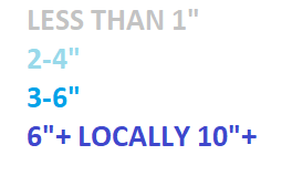
Final Numbers Central Park - 3-5" LGA - 2-4" JFK - 1-3" Islip - 1-2" Newark - 3-5" HPN - 3-6" SWF - 6-10" Danbury - 2-4" Morristown - 4-8" New Brunswick - 2-4"
-
Observations of snow, sleet, freezing rain Sun-Tue Dec 1-2-early 3
NJwx85 replied to wdrag's topic in New York City Metro
Snow started falling in Ramsey around 8:20. Temperature was 30 degrees. Currently have light snow falling. Flake size is quite large. Already around a coating of new snow on all surfaces. -
Puking snow for the last half hour. Already accumulating.
-
Very dangerous out there right now. 27 degrees with light zr. Coating of ice on everything.
-
Currently 27 degrees here with light freezing rain.
-
Warning here for 5-12” of snow and up to 1/4” of ice.
-
Just remember that historically speaking models under perform with CAD or low level cold air. Could get quite icy in interior sections tonight.
-
Not a big fan of the fact that the start time keeps getting pushed back. It’s more likely now that precip starts as a mix now rather than as snow.
-
Just based on history, these backend deformation bands rarely work out for us. It’s usually people to our North and East that get clobbered.
-
I think 1-3” is a great call for the city with 2-4” for the immediate NW suburbs and parts of LI. 3-6” once you get near 287 in NJ and North of the Thruway in Rockland. 4-8” for Northern Westchester, 3-6” near the Tappan Zee bridge and 1-3” for Southern Westchester and the Northern Bronx. Once North of 84 in NY I like 6-10”, same for the Pocoos and extreme NW NJ. NW of Newburg I see the greatest potential for >12”.
-
November 2019 General Discussions & Observations Thread
NJwx85 replied to Rtd208's topic in New York City Metro
Sun is out here


