

NEPASnow
-
Posts
42 -
Joined
-
Last visited
Content Type
Profiles
Blogs
Forums
American Weather
Media Demo
Store
Gallery
Everything posted by NEPASnow
-
helpful response snowman
-
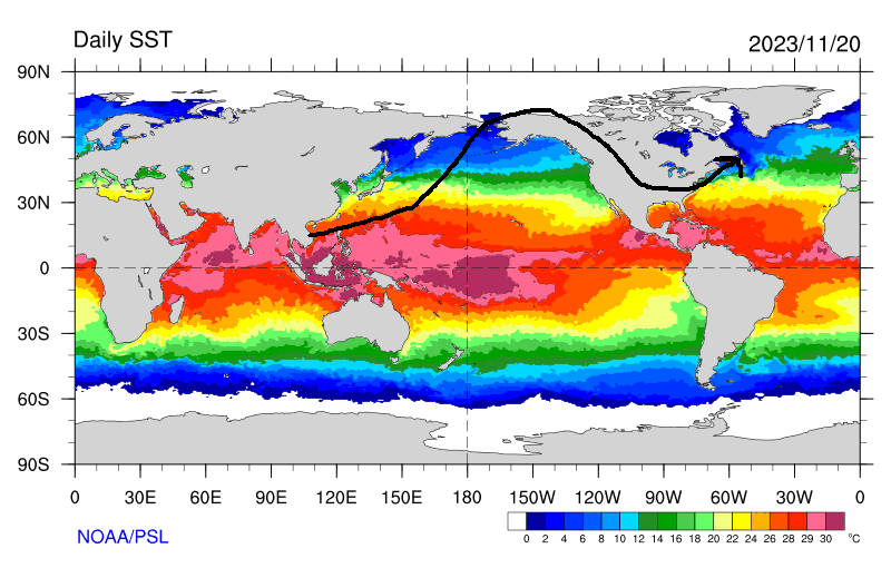
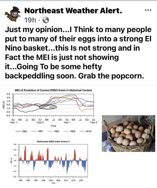
I know some people don't appreciate Steve Dimartino , but I wanted to get some posters on here opinions as well. " We know that El Nino has shifted from an east-based to basin-wide in the past few weeks, but the subsurface anomalies suggest that this El Nino could shift further west over the next few weeks. The warmest subsurface anomalies are pushing towards NINO 3.4 and NINO 4 for the first time in this El Nino event. What catches my eye is that this warm water pool is several hundred meters deep, suggesting that future upwelling will produce equally warm temperature anomalies. Meanwhile, the support for sustained anomalies over 1.5° in NINO 1+2 and NINO 3 is rapidly waning."
-
-
Thought it was a central based El Nino now with 3 & 3.4 being the warmest?
-
Is there any truth to this, I've never heard of this before. is this related to sun spots?
-
WWB will cause a temporary but not permanent warming and will eventually revert back to where it was before. With 3.4 becoming the warmest and is goes to basin wide with best forcing around the equator still. I linked the time where this is mentioned. Good Video
.thumb.png.feffae9b9d91df1d1a2a336862bfe1ac.png)
-
Thank you, just trying to learn a little bit more each day
-
So would this current el nino SSTA, if they were to stay similar, cause this type of jet stream pattern for winter?
-
Steve D Posted 1 hour ago Steve D In the Summer, I suggested that this El Nino would shift from a strong east-based orientation in the sea surface temperature anomalies to a basin-wide orientation. That forecast idea has officially been verified and will continue to shift, given the trends of the SSTA over the past two months. The sub-surface anomalies support a continued gradual cooling in NINO 1+2 and warming in NINO 3.4. Considering the sub-surface trends and evolution of this El Nino state, I expect NINO 4 to peak at around 1.8°C, NINO 3.4 to peak at 2.1°C, NINO 3 at 2.2°C, and NINO 1+2 to cool to 1.8°C through December and January. Meanwhile, there have been no changes to the atmospheric response, with the SOI continuing to remain in a weak to moderate El Nino response and the location of the strongest tropical forcing and convective development around the dateline. As a result, I expect we’ll continue to have this El Nino produce an MJO signal more frequently in phases 8,1 and 2 than in any other phases over the next three months. So far, the forecast for this El Nino has evolved exactly as I had expected
-
-
The SSTA would suggest a strong east-based El Nino but the forcing mechanisms would suggest a weak to moderate west-based El Nino with all the tropical convection firing along the dateline. Throw in the models showing a possible 3-lobed destruction of the PV by the end of November and we could be rocking and rolling till March with the atmosphere feeding back on itself with a -NAO and storms and cold. That sounds good to me
-
-
is the convenction still west along the dateline due to the cold water below Hawaii?
-
are we still looking for more of a central based El Nino?
-
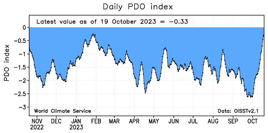
what would a +PDO do for winter on east coast in our current setup. It appears the -PDO is getting erased currently.
-


.png.9cfa01df61425bf4a71eed1c5ebd1a54.png)
