hlcater
-
Posts
2,670 -
Joined
-
Last visited
Content Type
Profiles
Blogs
Forums
American Weather
Media Demo
Store
Gallery
Everything posted by hlcater
-
It is the Iowa derecho. Makes sandy look like child’s play. Not too often when you get a “category 4 inland hurricane”!
-
What a storm.
-
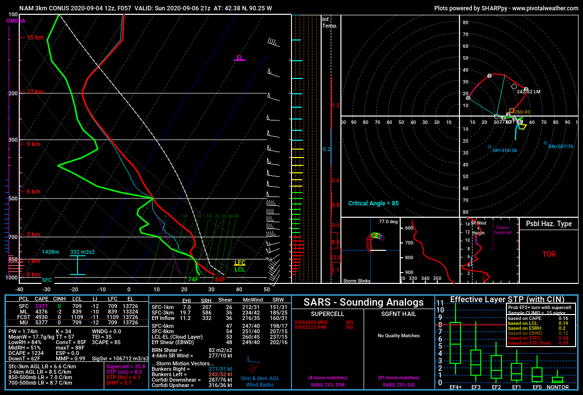
Imagine wasting hodographs like these because 700mb temps are 2 degrees too warm.
-
I wish it was. At least then we wouldn’t be having this discussion.
-
Imagine a good chunk of Iowa developing D3 drought and then receiving 5+ inches of rain in like 3-4 days.
-
DOA
-
The thermal ridge at 700mb is going to be too strong. It will initate, but after dark and along the CF.
-
The T/Td intersection below the EML is cloud cover, and one of the reasons why I’m not at all confident in initiation. That and the stout EML above it are extremely problematic. Regarding the hodograph, veered flow probably isn’t an issue here as the flow aloft is NWly and the resulting hodograph is quite tasty imo. I don’t have many concerns about the parameter space not being able to support a severe/tornado threat. For me, it’s more of what is the chance we get a robust updraft?
-
Some models either do initiate or become extremely close to initiating a storm in this environment. E IA/N IL. I still don’t like EML strength(14c 700s) and subsidence in IA. But far E IA and IL might have a chance....

-
Michael is my ideal hurricane. Fast moving, landfall at 90 degrees, in an area thats not too populated, in the middle of the day, clear eye/intensifying into landfall, in the US, the list goes on.
-
Most models look like that sunday in Iowa. Huge deal if they somehow end up uncapped, but with a reservoir of 14c 700s to the west AND westerly 700mb flow, that's probably not happening.
-
-
Yea 90% certain that Nana gets downgraded in post.
-
Some models do Saturday further west, and some more also have a setup on Monday. Saturday may end up capped due to the lack of a well developed wave. Monday might not exist at all, though the 00z Euro and 12z GFS do each have setups on Monday, even though they are vastly different.
-
always has been
-
hi
-
Reminds me of TS gordon off the coast of the glades in 2018. It too had a tiny little eyewall structure and well defined core and it fell apart. My guess is recon sampled a similar feature and as such, my guess is that it's longevity/potency is dubious at best. It'd be interesting if it found a way to maintain it though.
-
There's an excellent dataset on wunderground, except it doesn't appear as if any of the PWSs in Benton/Linn actually have data stored for 8/10, go figure.
-
As did I, my guess is that due to the scale of the MCV feature, the average gradient generated by an MCV w/strong RIJ is somewhere in between a hurricane and a tornado.
-
I checked and it's actually way, way greater. For instance, Josh's censors in Michael at Panama City peaked at ~1.5mb/min. This is 3.0-3.5mb/min, obviously. I'm interested in the context of a reading like that relative to other MCVs/Derechoes so I've been looking for comparable data, particularly BAMEX.
-
uhhhh 25mb/7min is pretty insane...
-
So Derek Smith?
-
You're gonna want to watch these 3 videos. They are the most impressive out of any of the video I've seen so far and are easily on par with a significant, perhaps major, hurricane. MANY gusts over 100mph and the sustained winds are the highest I've seen out of any video.
-
Environment looks pretty decent by Caribbean standards, not sure why models are struggling to do much. There's some dryness out ahead of it, but shear is light and when it exists, it seems to be northerly or easterly. Though it's not actually getting much help from upper level divergence, as it is only modest at best.
-
0.00 in Iowa City expansion of D1 is probable given the next week+ is cool and dry.