hlcater
-
Posts
2,670 -
Joined
-
Last visited
Content Type
Profiles
Blogs
Forums
American Weather
Media Demo
Store
Gallery
Everything posted by hlcater
-
Well that was inevitable
-
Dont know where to put this so it goes here. Papin is now an NHC forecaster. Good for him
-
I remember when people, including myself, thought this was gonna rip a hole in space-time in the W Carib. Fun times.
-
I dont like that
-
Probably at peak intensity now or close to it. Favorable shear window is closing and shear begins to increase again by early morning and should induce weakening by mid day or early afternoon at the latest. A fairly large cat 3 peak offshore should be sufficient for another respectable (9-11ft+) surge along the SW LA coastline. Pretty incredible to think areas that saw 15+ ft of inundation last time around could see 10+ ft not a few weeks later. Think that would probably drive me out of SW LA or into the bottle personally.
-
Delta honestly looks great right now, likely as of a result of the last minimization of shear(~15kts down to ~10kts) prior to landfall due to the turn more northward over the past several hours. Has through tomorrow morning to continue intensifying. In the near term, if current convective intensity persists and continues to expand like it has been this evening, a sneaky return to cat 4 would not surprise me before weakening starts to ensue tomorrow morning afternoon landfall.
-
the 119kt measurement was at flight level. SFMRs are being funny at the surface, with a 39kt reading right where you'd expect vmax to be. Not entirely sure they're reliable, but who knows. Standard reduction and pressure falls lend themselves to an upgrade to 100kt C3.
-
those are flight level winds.
-
Regardless of all that, this is probably knocking on the door of cat 3 intensity again.
-
I thought the eye was clear 2 days ago? This is news?
-
Need better symmetry in the bursts like we had earlier. I don't think it's weakening right now though based on satellite, just not strengthening.
-
Honestly has a better convective pattern than yesterday lol.
-
That's putting it mildly. Granted, GOM upper layer SSTs have come down. But unfortunately upper spreading divergence is bonkers. Delta's vortex is going to intensify rapidly. 28+SSTs are perfect for the kind of poleward outflow it will experience. Simply put, it's entering a hyped environment. Lapse rates are on steroids. Think this reattains Category 4 but as a much larger hurricane. The upper divergence and excellent poleward outflow channel are the biggest pluses for sure. 28c SSTs aren't really gonna help much, but they shouldn't really hurt either. That microwave pass was the first time I've been impressed by delta in the past 30 hours. Really thought it would explode yesterday and it probably would've gotten away with it too if it werent for that meddling shear.
-
Recon says the bleeding hasnt stopped. Up to 967 extrap and a max of 85kts FL in the NW quad. Yikes.
-
Yea delta is exhibiting symptoms of high shear right now. My call from earlier this afternoon will be far too intense.
-
Shear appears to reduce later tonight and through landfall. Should have a 8hr window with negligible shear prior to landfall. Not likely enough time to go sub 900, but may be enough time to clear the eye out. The ongoing convective burst is probably inducing pressure falls again, symmetric or not.
-
fringe radar image suggests maybe a larger eye trying to take over/absorb the 4nmi wide eye. Regardless, I think intensification is probably done for now. Remains to be seen whether it resumes later.
-
As expected, the inner core/eyewall is a mess.
-
Next plane looks to be wheels up at 00z with nearly continuous coverage overnight.
-
Why are we shitting on Jim Edds lol. The dude knows more about hurricanes than the vast majority of us. Not only that, the call wasn't even that bullish. Bullish for sure but not impossible.
-
8am eastern, 7am central
-
That shear is probably why the core is messy. Per GFS soundings, shear decreases again tonight and through landfall. Landfall is ~12z tomorrow so we've got one more diurnal max to really make it. First landfall call for me is 916mb/145kt. EDIT: I'll add the core being messy now is bad news for cancun. We won't get an EWRC with a messy core.
-
If the eye closes, clears and there isn’t an EWRC, it may be possible. Gotta keep in mind we’ve got a -80 ring and we’re already at 140/956 even with the core being a mess.
-
Only think that throws a wrench in this now is an EWRC. With such a small eye, something to watch for. But the storm is equally small so who knows.
-
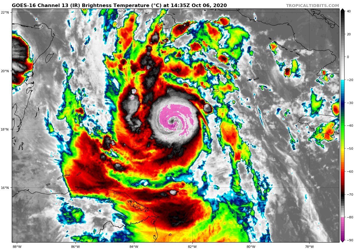
This thing is TINY. 6nm wide eye and a hurricane force wind diameter of maybe 15-20nm. Still strengthening in earnest and that CDO is freezing cold. If the eye closes and pops, pressure is gonna free fall I think.