hlcater
-
Posts
2,670 -
Joined
-
Last visited
Content Type
Profiles
Blogs
Forums
American Weather
Media Demo
Store
Gallery
Everything posted by hlcater
-
Wonder how much D3/4 there is by August 31st...
-
It’s been pretty wet here over the past week, and unlike places further east, it appears that should continue to be the case over the next 7 days as well.
-
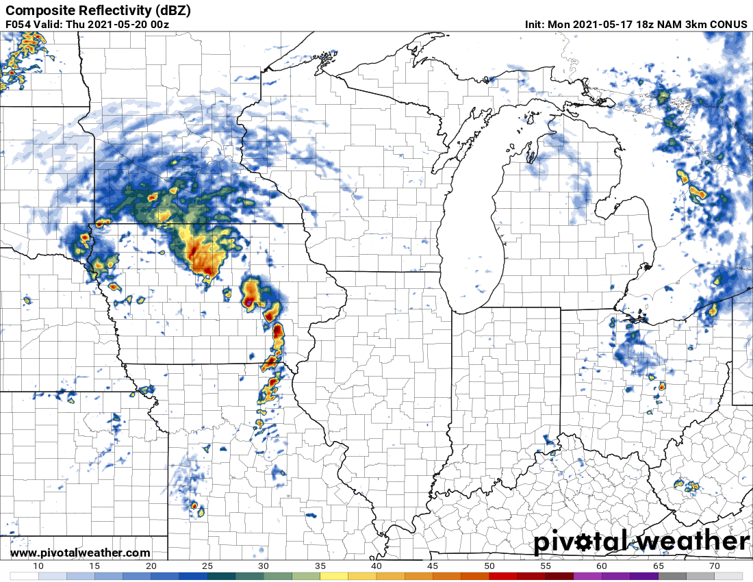
All in on the 3km NAM for this Midwest classic


-
This is honestly so pathetic
-
If RHs in the teens across much of northern Iowa isn’t a harbinger of drought, I don’t know what is.... Soil moisture must be totally abysmal with the lack of any appreciable precip recently. Things may be looking up with upcoming pattern change, or at least I hope so, because we’re gonna have some real problems if not.
-
-
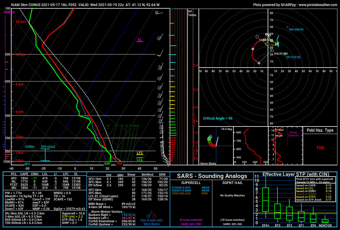
Geez that storm is a monster. Nothing really stopping it from becoming a true long tracker either.
-
Normally you see forecast soundings like this localized along a warm front or at the triple point, but almost never do you see something like this taking shape over an entire region. Click anywhere from the KY/TN border down to I-20 and you're gonna get something that looks like this. These are the types of environments that produce violent tornadoes, and the spatial expanse of this type of environment tomorrow is nothing short of jaw dropping. Barring slowed warm front progression or storm mode concerns, I just don't see how we get away from this event unscathed. This is a totally different animal from last wednesday. Not even comparable. As such, if confidence increases, I wouldn't be surprised to see the high stretch in that area from the I-20 corridor to the KY/TN border.
-
No way this doesnt go high at 06z. Period.
-
MEG sucks.
-
I too worry about high levels of storm traffic in the warm sector. EML is impressive early on but doesn’t really result in much residual CINH by 18z. I wonder if this allows 69 updrafts to initiate all at once and just ram into each other and impede the ability for deep rotating mesocyclones to develop.
-
Agreed on that point. Though I think the EML in and of itself is actually sufficient, or at least sufficient enough to hold through 18z if it didn't erode quite so quickly and instead allowed for surface heating to overcome it.
-
I'm not entirely sure what you're seeing. EML is present and accounted for on much of guidance at 15z. Using the HRRR for visualization.
-
4/14/12 is the example that comes to mind There is no such thing as a D3 high though
-
They wont do a D2 high at 06z. Not coming up from a D3 ENH. My guess is D2 MDT with a mention of an upgrade in later outlooks
-
That's not necessarily true. I think capping will probably be sufficient through at least 17-18z to prevent widespread storm development in the warm sector courtesy of a bone dry EML arriving ahead of the trough. The primary difference that tomorrow has and something I think makes OWS convection more likely is that if you look aloft, there are substantial height falls over nearly the entire warm sector along with stout low level moist advection. These should work together to ensure the best possible shot at storms ahead of the primary band. As such, hodographs and strength of the low level jet late tomorrow afternoon will be something that needs to be monitored intensely given the possibility of (numerous?) discrete/semi-discrete rotating updrafts.
-
The issue on 5/20 was that the primary wave lagged and deep large scale lift never really overspread the warm sector like it was projected to on the HRRR. I remember distinctly that there were no shortage of updrafts but they lacked better support to really root and take hold. Additionally concerns with the EML not really eroding(again due to lag in trough) and smoke keeping temps down by 2-3 degrees. The thing that is problematic tomorrow in this regard is that track of the trough encourages large scale lift overspreading the warm sector by 21z which should encourage OWS development. However, like you, I too wonder if this activity struggles to produce anything more than brief tornadoes as there is a distinct lack of enlargement/curvature in the 0-3km hodographs until the LLJ ramps up. At which point it becomes a question of what do the storms look like when it does? There's no ifs ands or buts about the environment between 00-03z, but do discrete supercells still exist at that hour to take advantage of it? I personally would hold at a large moderate risk until that question can be answered. I'll also add that for some reasons, CAMs ALWAYS struggle to produce UDH swaths in dixie. I'm not sure why, but I have noticed it.
-
Remember when this site had 50+ pages of quality discussion for an upcoming severe event and not 3 pages of trash? Pepperidge Farm remembers.
-
Of course I check in here and see someone posting the GFDL C-Shield lol.
-

Beware the Ides of March (and into the 16th)
hlcater replied to Hoosier's topic in Lakes/Ohio Valley
There's this super subtle detail on the HRRR that I think is likely responsible for the heavier snow further south. On the 18z run, there's a patch of really quite dry surface dewpoints in the mid to upper teens that gets advected in later tonight. As this area of lower dews gets moistened, it increases the effects of evap cooling and leads to an overall cooler column than other models at the same time ---> heavier snow further south. It's more evident on skew Ts but I cant gif those -
you called?
-
Felt like spring watching dry air entrained towers in Mason City too. We love that feeling
-
Solid A here. Overall a very consistent winter that had almost everything you could ask for out here. All 3 months finished AA for snowfall, will finish with ~65 days of continuous snow depth and had arctic cold. Like Hawkeye said, the one thing this winter lacked is a big storm and for that reason, I'm not gonna give it an A+.
-
Exactly. Upper 50s dews could work with a better developed low and a bit better of a lapse rate plume (as illustrated on the 00z run), but the low 50s present on the 12z arent gonna cut it, especially as the lapse rates arent as good either. Biggest issue is low lat trough that scours the gulf in 3-4 days, and this time of year, you need a lot of recovery time to really get that better moisture north of dixie. I'm interested in what follows this system, which should have better moisture to work with than this one will.
-
crush em with the low 50s dews on that run