hlcater
-
Posts
2,670 -
Joined
-
Last visited
Content Type
Profiles
Blogs
Forums
American Weather
Media Demo
Store
Gallery
Everything posted by hlcater
-
Wondering if there's some funny business on the OFB/western edge of the cold pool later. Especially as that boundary is now cooking under full sun. Could be an alternative play to wisconsin.
-
Agreed. Much like today, I don't think anyone can argue against the threat of widespread severe weather again tomorrow, especially as there is finally some respectable mid level flow. That, combined with a thermodynamic environment that is in many ways similar to today (perhaps slightly less extreme) should yield, at the very least, a threat for damaging winds in linear segments. The part I'm less confident on is how this evolves in the context of supercells. Effective shear should meet or exceed 40kts which is also a breath of fresh air, but there isn't really a ton of directional shear available as winds should be SSWly, even optimistically. Secondly, shear vectors off the boundary are.... not great at ~45 degrees or so. With both those things in mind, the way I see this working out from a supercell/tornado standpoint is for the modeled MCS on CAMs later tonight to throw a boundary and then chase wherever that boundary intersects with the cold front. I'm not sure there's enough directional shear or a high enough chance for a discrete supercell otherwise. Should note that the HRRR is again overmixing tomorrows dewpoints into the 60s along the boundaries, while consensus has dews near 80, so it can be tossed.
-
Storms taking shape nicely north of 20
-
The HRRR is trash. Look at the spreads it’s cranking out. 97/67? Lol nah. Let’s try 91/78. Based on obs, that’s where we’re heading
-
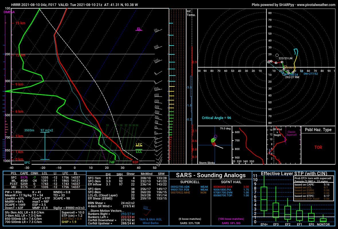
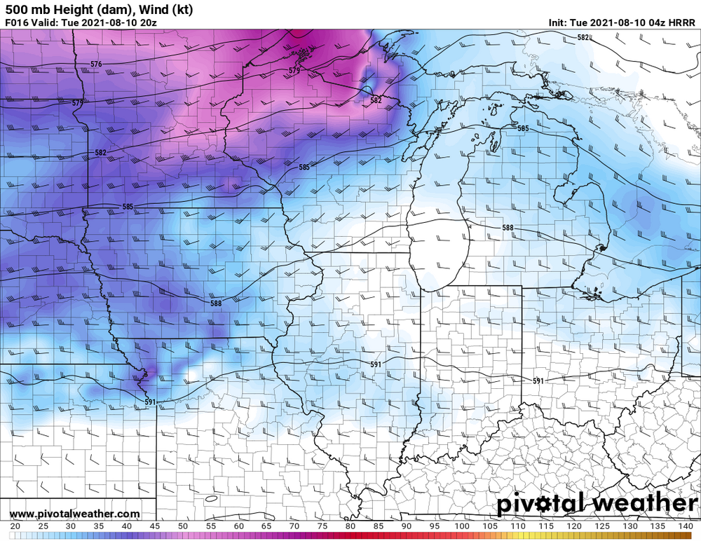
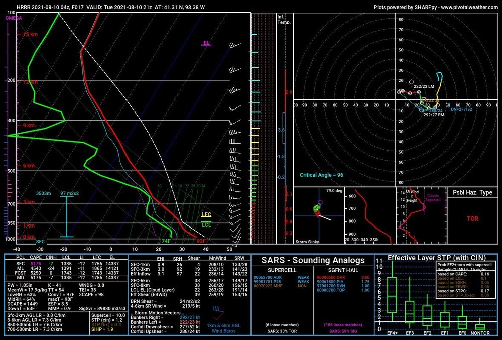
Just as today was obvious for tornadoes. Tomorrow is obvious for damaging winds. Perhaps significant. Cams vary widely on placement, but this setup has instability and low level lapse rates in excess and a conservative 25 kts of EBWD. That said, there has been a trend on the HRRR for a shortwave to round the base of the larger scale trough tomorrow and over spread the extremely unstable (5000 MLCAPE??) warm sector with 35-40kts of flow. If this scenario is realized, all bets are off.
-
Solid call on the 10. ez tornado day that was painfully obvious last night. Not at all surprised
-
I honestly didn't think LL SRH was that impressive(150 0-1, 300 0-3). What stuck out to me more was the excess of 0-3km CAPE/vort associated with that old MCV style feature. This, combined with sufficient SRH should yield opportunities for tornadoes even if storm mode was messy. I just think it will be difficult for longer lived mesocyclones to develop due to both storm interaction and poor EBWD somewhat capping potential of this event somewhat. As far as damaging winds, I think LRs are poor, but a few bowing segments near and after 00z could yield marginally severe gusts, so I think a 15 is good there too.
-
I think storm mode and sustenance concerns are enough to preclude an enhanced if you ask me. I think the 5 is fine
-
Ez tornadoes in IL tomorrow. Book it. I won’t be chasing though
-
lol that's hilarious.
-
Some rain would be nice
-
Had to work yesterday and missed all the tornadoes. Even better the forecast I had made was money and I would've seen the Jewell tornado.
-
This is looking pretty sauced up along residual OFB in IA.
-
Lol. We are aging well this hour
-
I’d lean bearish on near term intensity. Having such a fast forward motion and attendant strong fetch on the northern side is going to favor a very lopsided system even if shear and dry air are negligible. I suspect that the system will appear reminiscent of some of those later season gulf storms from recent years that suffer from the same issue, just rotated 90 degrees. Think the best shot for respectable intensification is after FH48 when this is in the eastern Caribbean and slowing down.
-

June 20th, 2021 Severe Weather Event
hlcater replied to HillsdaleMIWeather's topic in Lakes/Ohio Valley
I was originally gonna play the MCV in Illinois but it became evident early on that it was going to be a wash due to a westward propagating MCS in MO the night before. Due to this, I chose to target Marshalltown back on the cold front as I believed odds of destabilization and recovery were higher than on the MCV. I had forgotten my SD card for this chase, so all these are all high-quality iPhone captures.The first supercell went up and matured rather quickly near Ankeny. But seemed too early for the LLJ and didn't really do a whole lot while I was on it but it did feature high contrast and was quite photogenic at times as Ethan showed above. Despite this, I abandoned it at Searsboro for the storm that was quickly becoming dominant to the SW. Near Newton at 5:10pm. The first storm came closest to producing at this occlusion here at about 5:45 near Kellogg and it's a shame it lacked the extra kick it needed, because a tornado there would've been wickedly photogenic and I was in the perfect spot to view it. The 2nd storm was much more grungy and less photogenic, but never the less a little bit healthier than the first. Needless to say by this point the LLJ had begun to increase and sufficiently enlarge low level hodographs and this is really the only reason I can think of for why the first storm struggled to do much and the 2nd storm produced two tornadoes.This shot is looking at it as I arrived at 6:35pm Insert tornado #1 6:44pm and #2 at 7:03pm The storm threw out a huge gust front after this and never really recovered inflow dominance. So I called the chase in Oskaloosa and went to go shoot sunset pics. These are both unedited. The skies were really *that* saturated.- 236 replies
-
- 10
-

-
June 20th, 2021 Severe Weather Event
hlcater replied to HillsdaleMIWeather's topic in Lakes/Ohio Valley
welcome to the storm chasing community... -
June 20th, 2021 Severe Weather Event
hlcater replied to HillsdaleMIWeather's topic in Lakes/Ohio Valley
I still could. Debating it. I just worry that playing the MCV puts you out of position for storms in Iowa and you end up missing both. I think there's tornadoes from the MCV, but I also think Iowa has a shot to maybe do something better, along with some regional bias -
June 20th, 2021 Severe Weather Event
hlcater replied to HillsdaleMIWeather's topic in Lakes/Ohio Valley
Made the decision to forego the MCV in favor of the front in eastern Iowa. Let's see how well that ages.... -
June 20th, 2021 Severe Weather Event
hlcater replied to HillsdaleMIWeather's topic in Lakes/Ohio Valley
you thinking wind or tornadoes? If tornadoes, that's bold. I could see wind though. Storms moving out of Iowa later tomorrow evening should organize into a robust QLCS of sorts. -
At face value, I think the stuff back on the cold front probably ends up being a mixed mode conglomeration of giant hailers while the tornadoes are on the MCV.
-
I’m not sure that it does honestly. As a general rule yea I think you’d be right, but in this instance I’m not so sure. The MCV moves through at 18-20z depending on the model and almost certainly has a tornado threat associated with it. The issue comes with wake subsidence and the veering of the flow that happens behind it. Despite the late transit time, recovery back on the front in Iowa looks almost assured, yet the models that don’t have the MCV have far more backed low level flow than those that do. Seeing as there’s a 35-45kt LLJ in place already, I’m not sure how much help the MCV is actually giving, especially at the cost of veered flow on the primary boundary. Not to mention lapse rates are far steeper to the west than they are invof MCV.
-
An ill-timed MCV/MCS moving through the TA at 18z really does a number on the plume of steeper lapse rates sunday. Should provide a tornado threat in its own right but cant help but think this particular setup is actually better off without the MCV. Let the synoptics do the work.
-
Tomorrow looks to provide a solid opportunity for a real nice MCS across Iowa. Looking at potentially 5000+ MLCAPE, where spreads and mixing should favor cold pools and outflow dominance along with a 40kt LLJ. If it were me on desk, I'd have already introduced a 30% wind.
-
Think these pop ups are gonna be the best we’re gonna be able to do for the next 7-10 days....