ma blizzard
-
Posts
2,830 -
Joined
-
Last visited
Content Type
Profiles
Blogs
Forums
American Weather
Media Demo
Store
Gallery
Everything posted by ma blizzard
-
this is important to call out .. a good number of our high end severe weather events have W / NW flow aloft
-
yeah if I had to nitpick I'd say we have had dewier summers and higher end heat waves, but this summer will def be remembered
-
legit HHH weather out there, haze is very noticeable ... potentially from the CA fires? can someone post that aerosol product?
-
we tried to tell 'em man lie, women lie, numbers don't lie
-
-
Summer 2020 Banter and random observations
ma blizzard replied to Baroclinic Zone's topic in New England
imagine a line of storms like that ripping thru CT? Might not have power for months -
Even in the "tropics" of SNE I've seen some pretty wild temp variance with deep snowpack in place. Growing up, my area was a pit relative to the surrounding terrain. I recall instances where I could be as much 10 degrees colder than other backyard sites just a couple miles away and ~150'-200' ft higher up. Not a common occurrence by any stretch, but when it would go calm imby it would really tank, while a little higher up it wasn't able to decouple.
-
don't look now but convection is trying to fire up again near the LLC
-
Agreed! Barring something unforeseen (cloud debris, etc), legit chance (better than last weekend) of making a run for 100 for the first time since 7/21/11. As you laid out, there are reasons to suggest this could "over-perform" relative to guidance.
-
sun / mon night gonna be brutal around KBOS Wouldn't be surprised if Sunday night ends up slightly warmer then Monday night in this area. I'm seeing more of W / WSW component to the surface flow Sun night compared to SW Mon night. Looking back at last weekend, the southerly component overnight def cooled this area off more than I would have expected during the nights. Either way looking at mins in the U70s - L80s
-
how long in the sun? I’ve never seen anything like that before ..
-
ORH up to 91/65, impressive
-
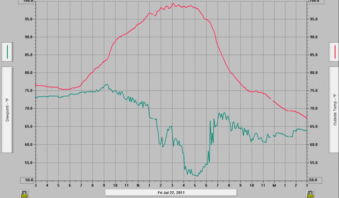
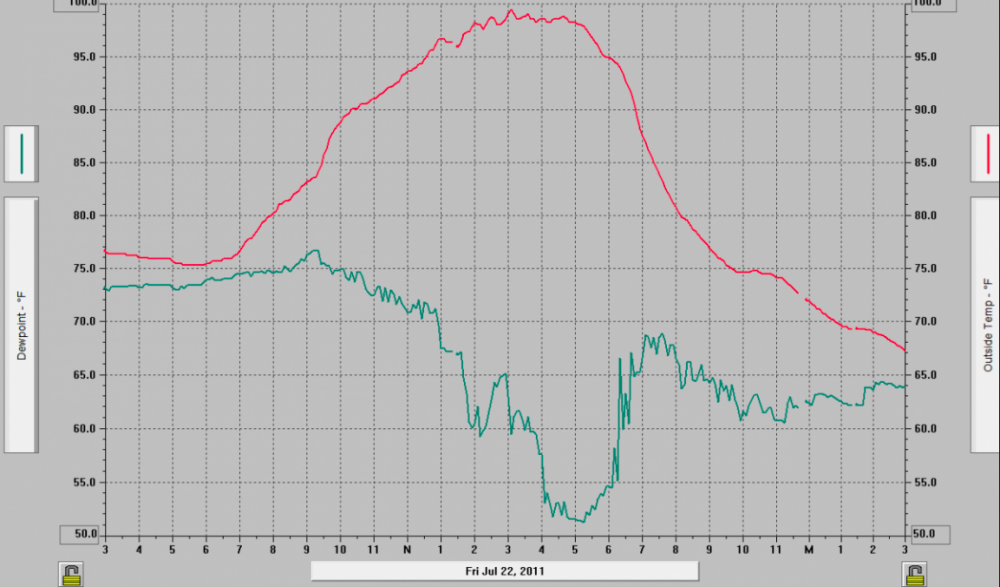
7/22/11 is great example of this! Data from my old Davis back home in Shrewsbury that day: you can see the temp starting to level off a bit at 96 around 1 pm with dews in the low 70s. dews mix out into the low 50s and you get that last 3-4 degree rise .. I believe max was 99.5 and by far the hottest temp I recorded there (since 2006)
-
orh was 86/55 earlier, it didnt just mix out in the valley lol
-
for 100 id wanna see no cloud contamination, high launching pad to start, if possible move the plume of 20-21 c 850 temps in earlier, and more of a west component wrt wind direction. even then you are counting on mixing to like 825-800 mb ish?
-
agreed, but maybe not a big under? I do think there will be a boundary ( ssw vs wsw flow) like that shown in that depiction that seperates MU 90s and dews in the low 60s and 90ish and dews around 70. Maybe bdl or ash could make a run at 100, but as of now id take the under by a hair. would need everything to go “right” but its in play imo
-
DIT closest career comp is prob Adam Dunn
-
TS Fay - Drought ending Rains and Severe Convection
ma blizzard replied to weatherwiz's topic in New England
I have a hard time believing Fay gets yanked hard left like that IMO we see Fay hug the coast before landfall east of NYC on LI -
a little rotation on the cell passing east of KFIT? looks like a good light show incoming for Boston area
-
toasty run on the Euro, heatwave potential next week?
-
Spring 2020 New England Banter & Random Obs
ma blizzard replied to CapturedNature's topic in New England
wiz you are lil child just grab a jar or Tupperware, put it over the spider, slide a piece of paper underneath and then you can put it back outside .. -
https://water.weather.gov/precip/ a good visual representation
-
solid running weather, but other than that it’s garbage
-
Saturday, June 27 - Sunday, June 28, 2020 Convective Thread
ma blizzard replied to weatherwiz's topic in New England
best storm of the year so far easy -
I've heard fireworks at all hours of the night the past 3 weeks in the city .. its been wild out here