ma blizzard
-
Posts
2,830 -
Joined
-
Last visited
Content Type
Profiles
Blogs
Forums
American Weather
Media Demo
Store
Gallery
Everything posted by ma blizzard
-
Active mid December with multiple event potential
ma blizzard replied to Typhoon Tip's topic in New England
18z Euro less robust than 12z with the Monday deal, maybe 1" or so where cold enough -
December 5-6, 2020 Storm Observations and Nowcast
ma blizzard replied to Baroclinic Zone's topic in New England
back in Shrewsbury for this one and def a lot of variance locally due to elevation .. only a coating so far imby at about 420', but at least an inch down at the center of town closer to 700' as of 11. Flipped to snow on the drive back at the rt 9 / 495 intersection at ~10:45. A little frustrating knowing just up the street from mby there's more snow on the roads then I have on the grass here seems like ~600'+ locally is the magic # -
Dec 5/6th major coastal/ west Atlantic cyclogenesis ...?
ma blizzard replied to Typhoon Tip's topic in New England
gun to ORH area 6"-12" is reasonable? -
Dec 5/6th major coastal/ west Atlantic cyclogenesis ...?
ma blizzard replied to Typhoon Tip's topic in New England
as you will find out, ORH is just far enough W, E, N, S ... Def gonna have to make the trek back to metro west tmrw morning for this one. Not liking my chances of seeing more than 2-4 where I'm at in Somerville. -
don't forget to consider how high agl the radar beam is at that distance
-
yup, we torch
-
-
we aren't locking in the 12z CMC run?
-
could be interesting to see what happens with 95L and how it may affect the modeling of that D6 deal
-
sneaky (shallow) cold airmass behind this front .. looks to be coldest in the 900-925mb layer (SNE)
-
its happened once
-
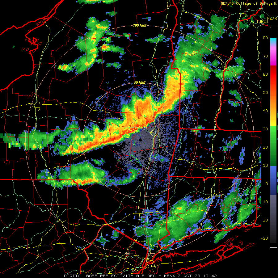
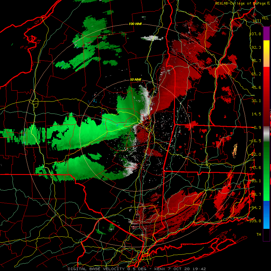
Wednesday, October 7, 2020 Convective Potential
ma blizzard replied to weatherwiz's topic in New England
KAQW 52kts -
Wednesday, October 7, 2020 Convective Potential
ma blizzard replied to weatherwiz's topic in New England
KALB 54 KT -
Wednesday, October 7, 2020 Convective Potential
ma blizzard replied to weatherwiz's topic in New England
line of storms about to go through Albany, impressive values on base velocity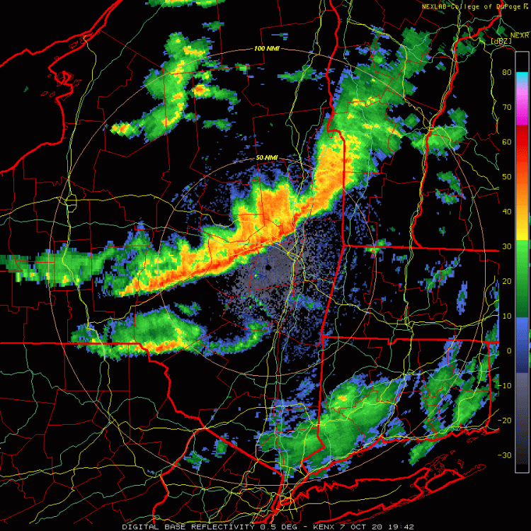

-
khabib?
-
-
its getting to be that time! the (dry) weather has been near ideal this past month tho
-
looks like we are 2-3 degrees ahead of last nights pace .. I think the colder sports locally are going to drop into the upper 20s
-
I'm putting the O/U for OWD at 29 tonight gonna be a tough one for the gardens in metro west the next 2 nights
-
frost would be ok if its one of those 70/34 type days i think .. i worry more about 2-3 days of clouds, drizzle, onshore flow. granted if something like the op euro verified I wouldn’t be thrilled. with that type of airmass, id be worried about a freeze in the spots that radiate well (unfortunately mby)
-
thanks for posting that! def seemed to be a little high, at least compared to KBED, KLWM, KIFT, KMHT, etc . .
-
wow you aren't kidding .. might be the highest dp I've ever seen locally KASH 101756Z VRB03KT 10SM FEW015 SCT065 27/26 A3018 RMK AO2 RAE37 SLP224 P0000 60000 T02670261 10272 20206 56024
-
I think it was well modeled tbh - at least when I took a look yesterday
-
-Wed looks like 70-75, clouds/showers, and rising dews -Thursday big torch, 85-90 and dews in the low 70s -Friday vintage DSD, 80s with dews dropping into the 40s/50s by late day Not exactly a 3 day furnace .. but Thursday def will be hot and humid if the models are right in the extended, could be a prolonged period of high dews and temps in the 80s coming up. Bet you can't wait to do the dew!
-
wasn’t the forecast for 12/97 to be 2”-4”? ended up being 18”-24” in 6-8 hours in a decent area