

ma blizzard
-
Posts
2,832 -
Joined
-
Last visited
Content Type
Profiles
Blogs
Forums
American Weather
Media Demo
Store
Gallery
Everything posted by ma blizzard
-
I'm thinking more for tomorrow afternoon/night with freezing drizzle after the main batch of precip moves through.
-
could get quite icy up your way .. we watch the cold drain tonight
-
Not record breaking stuff verbatim, but that looks frigid .. near ideal delivery angle straight from Baffin Island.
-
32/31, s- coating
-
Def want dynamics on your side in a setup where you start as rain and the colder air is filtering in during the storm.
-
38/28, flurries might be time for an obs thread to track the flurries?
-
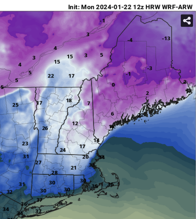
Still in clown range for the high-res meso models, but certainly an interesting look by 12z Wednesday: Magnitude of the cold drain is for sure overdone, but it should be something to watch for.
-
Could be the biggest over-performer of the year! 17, s-
-
radar actually doesn't look terrible .. maybe a solid burst to coat things up?
-
19, flurries a lot of hockey being played past couple days on the pond up the street looks and feels like winter at least
-
Too early too tell IMO, but I think Tuesday has a better shot than later next week with the follow up wave
-
At least it's something - Jan 16th Snow/Sleet/Ice OBS Thread
ma blizzard replied to The 4 Seasons's topic in New England
3.3" melted down to 0.51" 2.8" snow, 0.5" mostly sleet/zr -
At least it's something - Jan 16th Snow/Sleet/Ice OBS Thread
ma blizzard replied to The 4 Seasons's topic in New England
26.4/25 sleeting mixing in with freezing rain in shrewsbury .. looks like flip to snow soon -
At least it's something - Jan 16th Snow/Sleet/Ice OBS Thread
ma blizzard replied to The 4 Seasons's topic in New England
Same here just east of ORH .. temp down 0.4 past 30 mins Looks like as CC collapses east, we flip to IP and back to snow the next hour -
At least it's something - Jan 16th Snow/Sleet/Ice OBS Thread
ma blizzard replied to The 4 Seasons's topic in New England
gotta give credit to the models that showed the potential for 0.1"-0.25" QPF as freezing rain .. looks well on the way to verifying -
At least it's something - Jan 16th Snow/Sleet/Ice OBS Thread
ma blizzard replied to The 4 Seasons's topic in New England
27.5/26, Freezing Rain in shrewsbury starting to accrete -
At least it's something - Jan 16th Snow/Sleet/Ice OBS Thread
ma blizzard replied to The 4 Seasons's topic in New England
27.2/25 50/50 sleet/freezing rain in Shrewsbury -
At least it's something - Jan 16th Snow/Sleet/Ice OBS Thread
ma blizzard replied to The 4 Seasons's topic in New England
25.1/23, PL 2.8" in Shrewsbury before the transition to sleet -
At least it's something - Jan 16th Snow/Sleet/Ice OBS Thread
ma blizzard replied to The 4 Seasons's topic in New England
24.6/22, S- 1.9" -
I’ve been watching the same area and I think it could be? Its def been modeled as an area where it could form
-
flurries
-
Albany about to get smoked .. even more impressive squall going to pass just north of there too
-
For sure! It wouldn't take big changes to get this back to an advisory level event.
-
Def not, looks flat at 500
-
kinda acts like a SWFE .. good thump of snow to mix and then dry slot


