PowellVolz
-
Posts
3,819 -
Joined
-
Last visited
Content Type
Profiles
Blogs
Forums
American Weather
Media Demo
Store
Gallery
Everything posted by PowellVolz
-
We may need a sub thread for the 93’ storm. Or just past events in general. Snow and severe.
-
Sunday? Woah!!! Interesting
-
lol… apparently Ken Weathers from WATE had a thing or two to say about “so called social media meteorologist”. I didn’t see it but had a few people text me about it.
-
12z GFS went back south. Mobile to Atlanta to Charlotte is where the precipitation axis is. It could be underestimating the precipitation shield on the NW side but obviously we are not there yet to worry about. However I’m good with that run. It keeps us in play.
-
He also said in his opinion that February is looking like a potential trough out west and a strong SER setting the stage for severe weather to start early this spring.
-
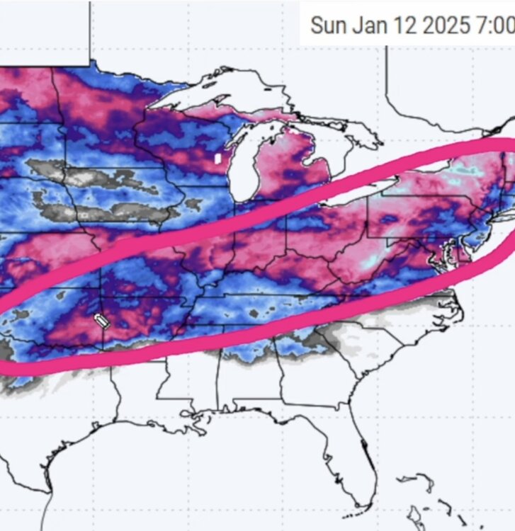
Ryan Hall with an interesting video today. He said between now and February 1st he believes the area circled on this screenshot I’m posting hasn’t seen half the snow to this point that he believes is coming in the next two weeks. He even threw out the “B” word that ends with a “D” as a real possibility in this circled area. I was shocked to say the least that he would go there. lol…
-
Jan 24’ was pretty incredible. Snowed for about 28ish hours, however the last 10 hours is where it left its mark. Seems like 2014 (if I’m remembering correctly) we had a similar situation but it ended up a big mess. 5” of snow turned to several inches of sleet, then a little FRz before we went back to snow. However it seems like there was two big storms several days apart with an inverted trough across the foothills that brought around 5” of snow in the valley. We had lows below zero for several nights. Didn’t break freezing for a week. School was out for two weeks. One of my schools had a sprinkler freeze and bust. We found it because the motion sensor caught the water rolling down the hall and it set the security alarm off. lol… I was there for 20 hours working. Good times
-

-
Leave it there until the 11th hour
-
 How much compaction do you all think? At least 1” overall?
 -
You been out any? Surprised how bad 33 is and Emory worse.
-
Moisture is below the radar now. Jet dynamics and the NW flow is squeezing out every bit of moisture that’s left. Still coming down pretty good at my house but only a haze on the radar.
-
Those things can’t stop worth a crap. I’m sure he wants to get home but dying ain’t worth it.
-
Took the new jeep out for a spin. The roads are gonna be a problem in the morning. Maynardville Hwy (33) is compacted. Emory Rd is a state highway hasn’t been scrapped. Cars off everywhere
-
Snow is filling in nicely down the southern valley
-
I was literally just thinking this is the hardest I’ve ever worked for a measly 3” of snow in my life.
-
I’m back to all snow in Halls
-
It literally sounds like it’s hailing in Halls.
-
Is that the DGZ issues that @TellicoWxwas talking about?
-
Same thing here up the road. Pouring the sleet with a little snow
-
Walked outside… getting a sleet storm rn. Measured right at 3” on top of my trash can.
-
Some of you with more intellect than me chime in please…. I don’t know if the Euro got this right but this system seems to have sheared out like it had been saying. Seems like the upper trough didn’t phase with the southern stream, or it was a very late phase. The ULJ is running over the top of the precipitation to our east while the trough is lagging behind in WTn. We still should be in the right exit of the trough as it moves through later on. So when the trough moves through, it can lift whatever moisture is left and wring it out in a NW flow situation. Thoughts?
-
It’s stretching all the way to Ala/Tenn line now and filling in.
-
Kinda surprised… NWS updated my forecast saying 1-3” the rest of the day with an additional 1-2” tonight before midnight.