PowellVolz
-
Posts
3,819 -
Joined
-
Last visited
Content Type
Profiles
Blogs
Forums
American Weather
Media Demo
Store
Gallery
Everything posted by PowellVolz
-
In house mod from a Met in Columbia SC. This isn’t a bad look IMO… https://twitter.com/daniel_bonds/status/1891167602203845081?s=46&t=LVg8BRWCh1zZb6F_t95EVg
-
I went to bed around 11:30est when it was evident that a widespread severe episode across Tennessee wasn’t happening. I’ll stay up for my friends in MTn if the threat is realized but I texted him at 10:55 and told them “all good”. However I’m seeing potential tornado damage in Gibson Co that looks pretty significant. https://x.com/brianemfinger/status/1891002844959912108?s=46
-
A Miller B or some sort of handoff always looks convoluted until the high res mods get in range and show the details. Seen it many of times where the NAM starts a trend 4 days out that looks jacked up but then the other mods start to follow in the next runs.
-
While the other mods are not showing a full blown handoff, the drop off in QPF east of the Plateau and then a resurgence of moisture on the NC side is unfortunately signs of the worst case scenario for ETn outside of elevation. If we are still talking about this tomorrow morning, it most likely is what it is.
-
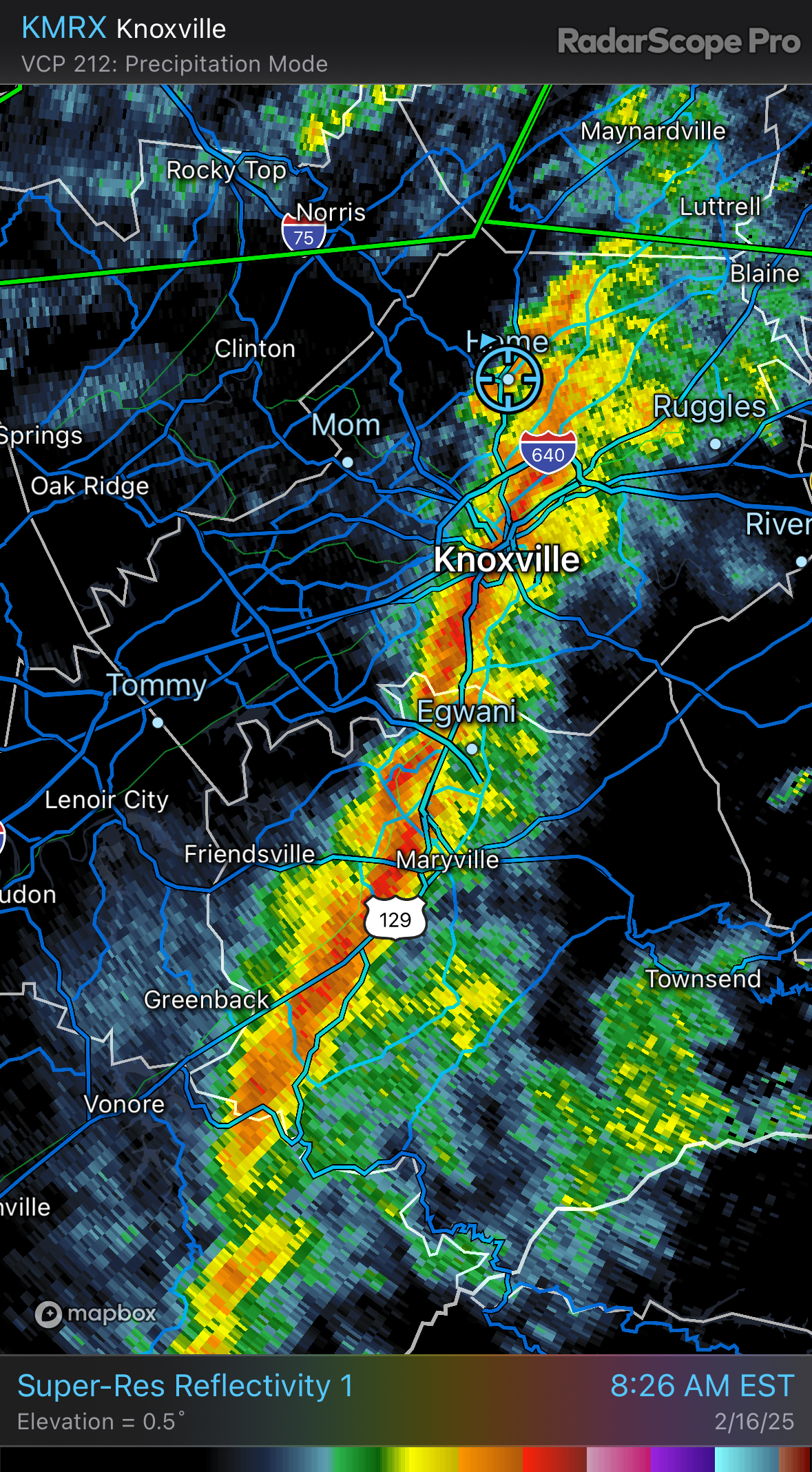
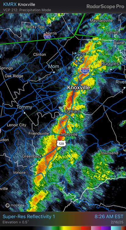
This secondary line developed this morning a little west of Knoxville and it moved through at 8:15 AM. I was getting ready for church when I heard my house cracking and then the power flickered multiple times. Had to be 50+mph winds. Anyone else have that?
-
Apparently not in Tennessee lol
-
Something to chew on… i know it’s been warm, however Monday-Wednesday the high/low temps in Knoxville will be around 40/25ish. This should help cool the ground temps.
-
Those were elevated as the WAA storms jumped the 1st warm front. Pretty common for those to have thunder even in a cold environment. The storms later on will probably be more surface based.
-
My buddy in Jackson Tn said his temps went from 54-68 in the last 30-60 minutes and the sun is now out.
-
I don’t see anyone east of the plateau getting any storms. Look at this inversion between my house and Roan Mt.
-
That rodent is only right when we don’t want him to be
-
If this thing heads to the Gulf of America I’m taking a trip up 81.
-
how classic is this look? That looks like a map from 30-40 years ago. one thing that very positive if you like mod conspiracies…. Wednesday morning we had a stupid snow storm on the Euro, 18”-24” area wide. The storm was “lost” for a couple of days and here we are 2 days later. Its not science but it seems to happen.
-
When we are talking snow, the first thing I do in the morning is pull up my TWC app while getting ready for work. They use a in house blend of their own now and it seems to be a good image of the overnight runs. Well… my 37918 went from up to 3” to up to 8”. So it’s a beautiful Friday
-
The severe could be a serious situation south of Tennessee on Saturday. High shear low CAPE usually doesn’t do well in ETn before we get to the warmer months. I’ve given my opinion before about the limitations of severe in ETN, especially in the Central Valley when we have a SW to NE storm motion. The other day was a good example of storm motion making a difference in the valley. That set up was just ok, however because we were dealing with west to east tracking supercells, the SW LLJ fed the storms at a better angle which keeps the mountains from disrupting low level flow.
-
my opinion is exactly that, my opinion and it shouldn’t be considered in any decisions but I like having a thread dedicated to severe. Makes it easier to get to the point of what your interest is. However I also see nothing wrong with some dialogue about upcoming severe events. Sometimes it can become convoluted trying to monitor different events that are multiple days apart.
-
that’s really weird for them… where they showing a computer mod when they said that or what? How did they present that?
-
I was wrong….
-
I won’t be surprised to see the 15% get pulled back out of Tennessee for tomorrow’s update. Not a good LP placement for February in Tennessee
-
seems like I read this a month ago.
-
We are going to be right there on that one or two degrees makes a difference line aren’t we?
-
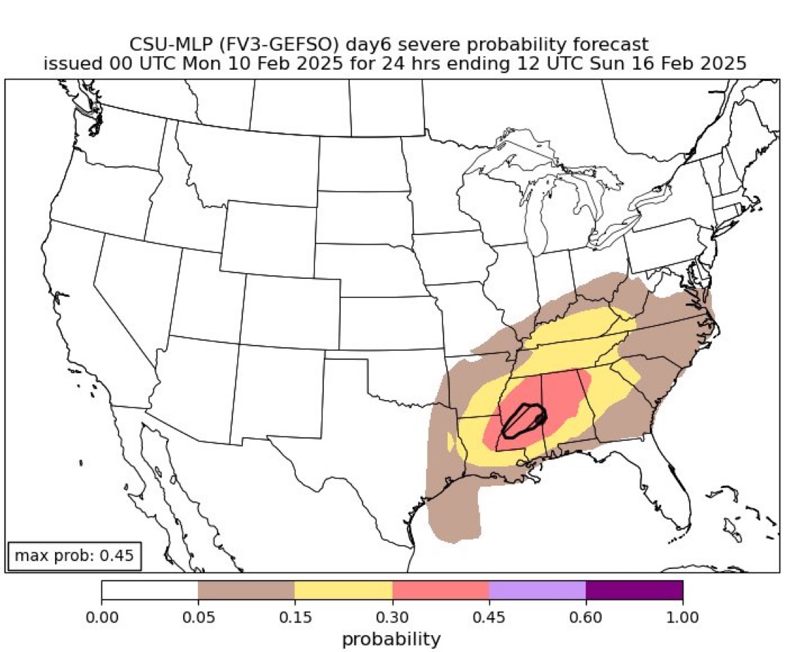
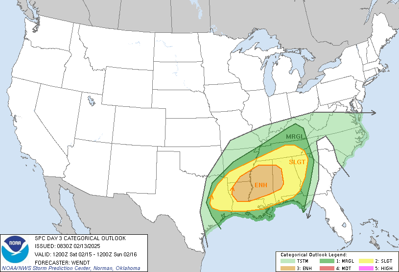
Looking like Saturday is going to be active. SPC has their D5 15% up into the valley now. and this….

-
do you remember their names? What sport? I played football and baseball. Played basketball my freshman, sophomore years before it became too much for me.
-
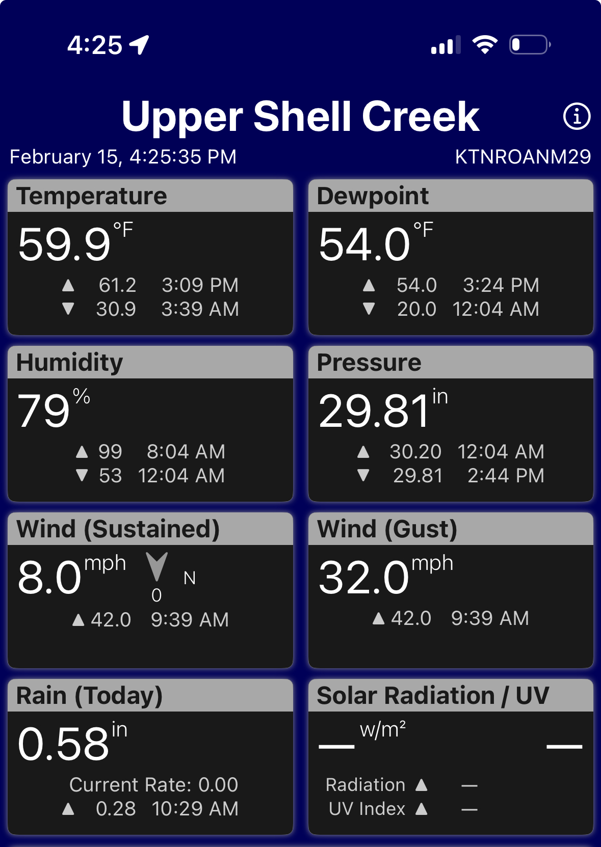
I have a friend that lives on Lynnview in Ft City. He said he’s never seen or heard anything like that. I live in Halls off Emory at 33 and i could hear the wind blowing through the trees on top of Black Oak. It was a 5 min nonstop roar that people talk about hearing.
-
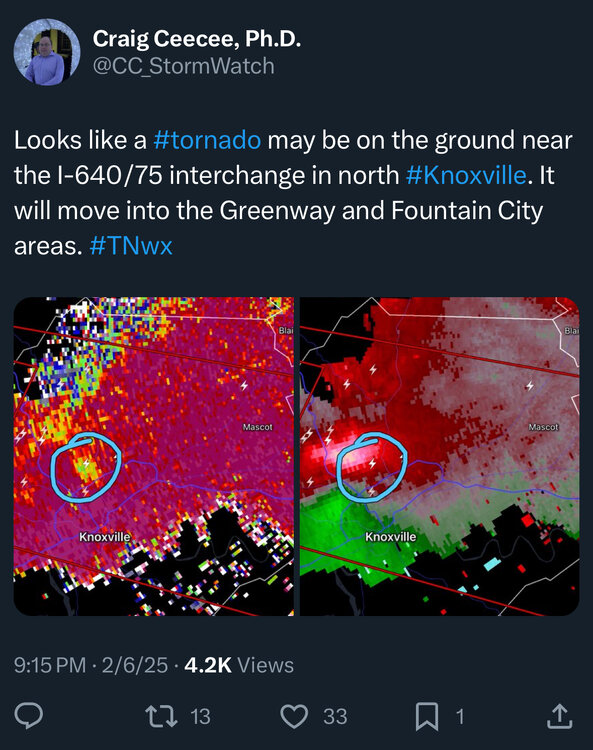
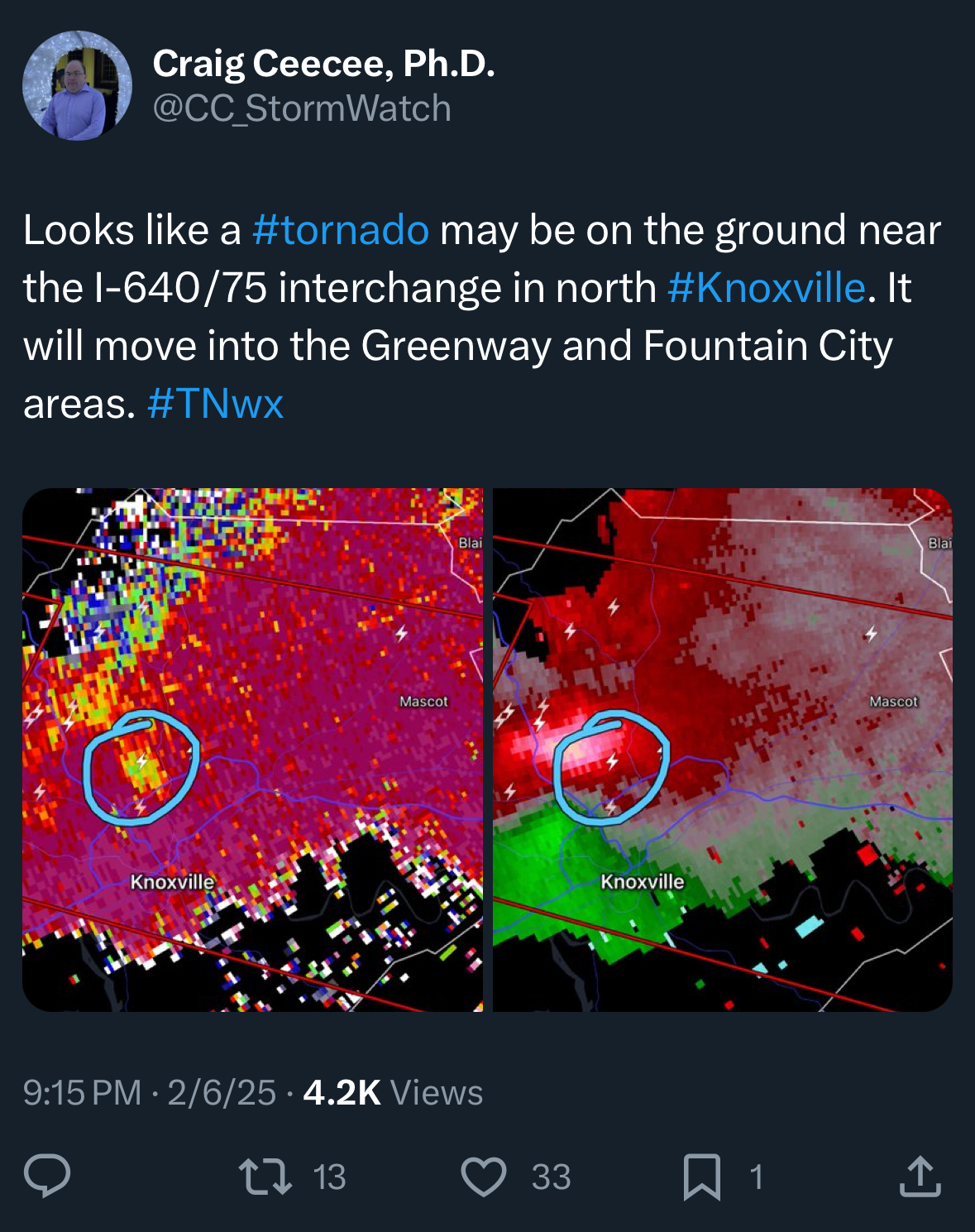
FYI….. the last time Knoxville had a tornado in February I was at my parents house in Powell and watched it go over us. It came back down in Broad Acres Subdivision a 1/2 mile away and produced F3 damage. It was on the ground for 12 miles from Powell to just past Ft City. 32 days after that tornado hit Knoxville, The Blizzard of 93 happened. this is from the storms the other night…..