PowellVolz
-
Posts
3,819 -
Joined
-
Last visited
Content Type
Profiles
Blogs
Forums
American Weather
Media Demo
Store
Gallery
Everything posted by PowellVolz
-
Honestly… this isn’t all that bad and it’s on the tail end of the system like a squall line on the cold front. What we don’t want is storms closer to the front of the moisture shield.
-
I was just thumbing through the mods and one thing I noticed…. The 18z mods appear to have better ratios than the 12z mods. Not sure if that’s because the mods are thinking the trailing wave has more juice or what.
-
That’s the same one the Columbia station was using.
-
I believe they use something similar to the Columbia SC news station that I’ve posted a couple of times.
-
my exact thoughts…. Almost like they are trying to talk themselves out of predicting snow. Considering their track record…. Im good with the Debbie Downer approach until we see flakes on the ground.
-
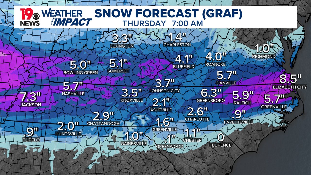
I’m also not agreeing with the issues of the sun in the morning thoughts. I agree it is part of the big picture but them acting like an hour or two onset delay is going to have major implications on the final accumulations is a head scratcher IMO. I don’t see the sun cutting into snow totals first thing in the morning with a low of 25 degrees in Knoxville, a solid cloud deck and snow falling. It hasn’t gotten above 38 degrees since yesterday afternoon, a low of 26 last night and the temps staying about the same until Wednesday morning should aid in snow accumulations IMO.
-
Yes and no if I remember correctly…. The Euro was the first mod to start showing qpf issues while most of the other mods were not. Then the other mods and the Euro kinda met in the middle 24 hours or so out if I’m remembering correctly
-
Nashville just pulled the trigger on WS warning and filled in everyone else with an advisory
-
One thing that’s not going to make forecasting this easy is this system potentially has a very low floor and a high ceiling depending on different variables that can’t really be pinpointed now. GOM convection could play a major role in return flow.
-
Columbia SC Met…

-
If that convection has a (kinda) positive tilt to it, would that be better than a W to E orientation? Also the convection kinda falls apart moving east. I’m wondering if that helps us any?
-
It was so difficult than all the other mods, something eventually had to give.
-
Absolutely it is.
-
lol… NAM now has snow to the Bama border but completely leaves out the valley up to Morristown but was a huge improvement
-
The 18z Icon doesn’t go all the way out but looking back and comparing it to 12z, i believe the end of the run is a little south of 12z and it looks like it could have more qpf. I didn’t do a deep dive but on the surface, that’s what i believe I see.
-
For us in Knoxville, especially on the north side, ever since the Christmas Eve Eve event several years ago, we have actually over performed on all of the bigger snows. Overrunning event in Jan 24, we were looking at 4”-7” and ended up with 8”-10”. This year has been disappointing, however i remember going years without anything more than an inch or two. There’s been a few disappointing events but since 2020 we have done ok.
-
Maybe, maybe not but too far away for details like that.
-
I can’t remember but it seems like I’ve seen lots of chatter on twitter about the NAM not doing well this winter. I don’t think it did well in our January flizzard either. Correct me if I’m wrong please.
-
im making a huge mistake here talking myself into believing common sense plays a role into forecasting winter weather in our neck of the woods. lol… take a breath Powell, or a Xanax. Lol
-
Is there any climo evidence that a solid high pressure over the top of a low pressure pass to our south ends up pushing the low further south than modeled? I don’t have a 1/4 of the knowledge you all do in winter storms but I can’t imagine this storm going back a little north in the 11th hour with how strong the cold push is on the NW side of the system.
-
Been quite a winter for Louisville to Lexington this year. Probably one of their best in a good while
-
North of I-40 in Tennessee looks ok right now but if we could get a 50 mile trend to the south, we would be in business. BAM weather on their last video thinks a south shift is possible. Also…. Just a little shift to the south would increase ratios north of 40. That would give us more bang for our buck without increasing qpf.
-
He’s talking about the end of next weekend into the following week. 7+ days from now.
-
It will help the mods when we get rid of last night’s system.
-
FYI…buddy of mine coming back from Nashville to Chattanooga repots moderate snow falling on Monteagle Mt. He also sent a picture that a friend sent him from Crossville of snow falling and laying on the side of the interstate.