PowellVolz
-
Posts
3,819 -
Joined
-
Last visited
About PowellVolz

Recent Profile Visitors
6,774 profile views


-
 Really cool meso page here guys. Everything you want in one stop, however some things are for a subscription but you can still do a lot, especially on the severe weather side. https://aguacerowx.com/app/
 -
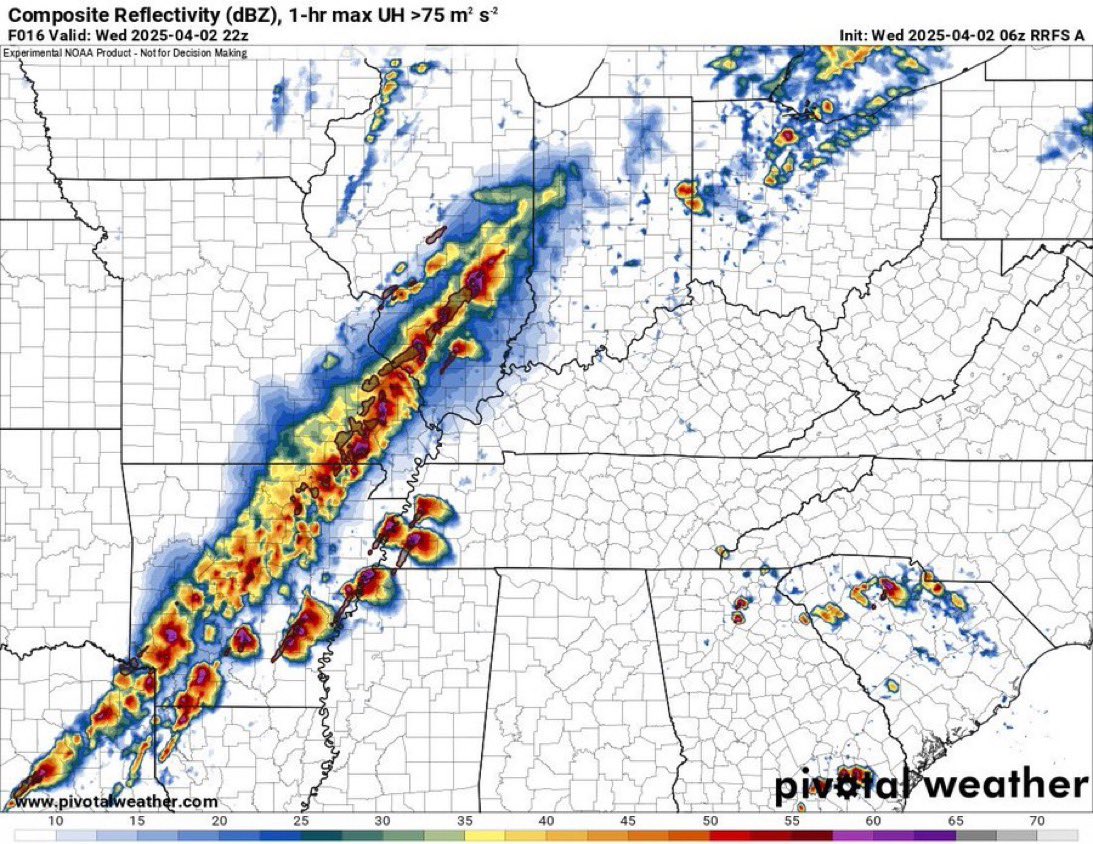
The RRFS CAM did well yesterday with the prefrontal supercells. It even got the storms in upstate SC right.


-
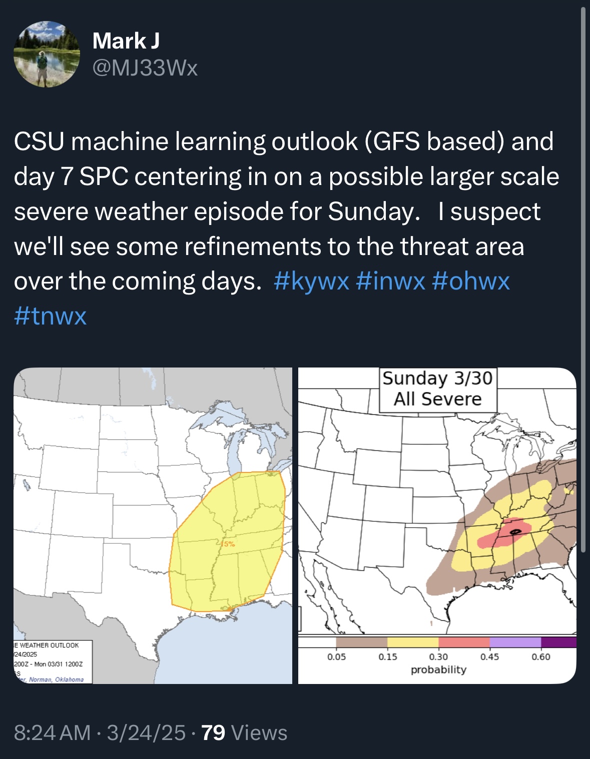
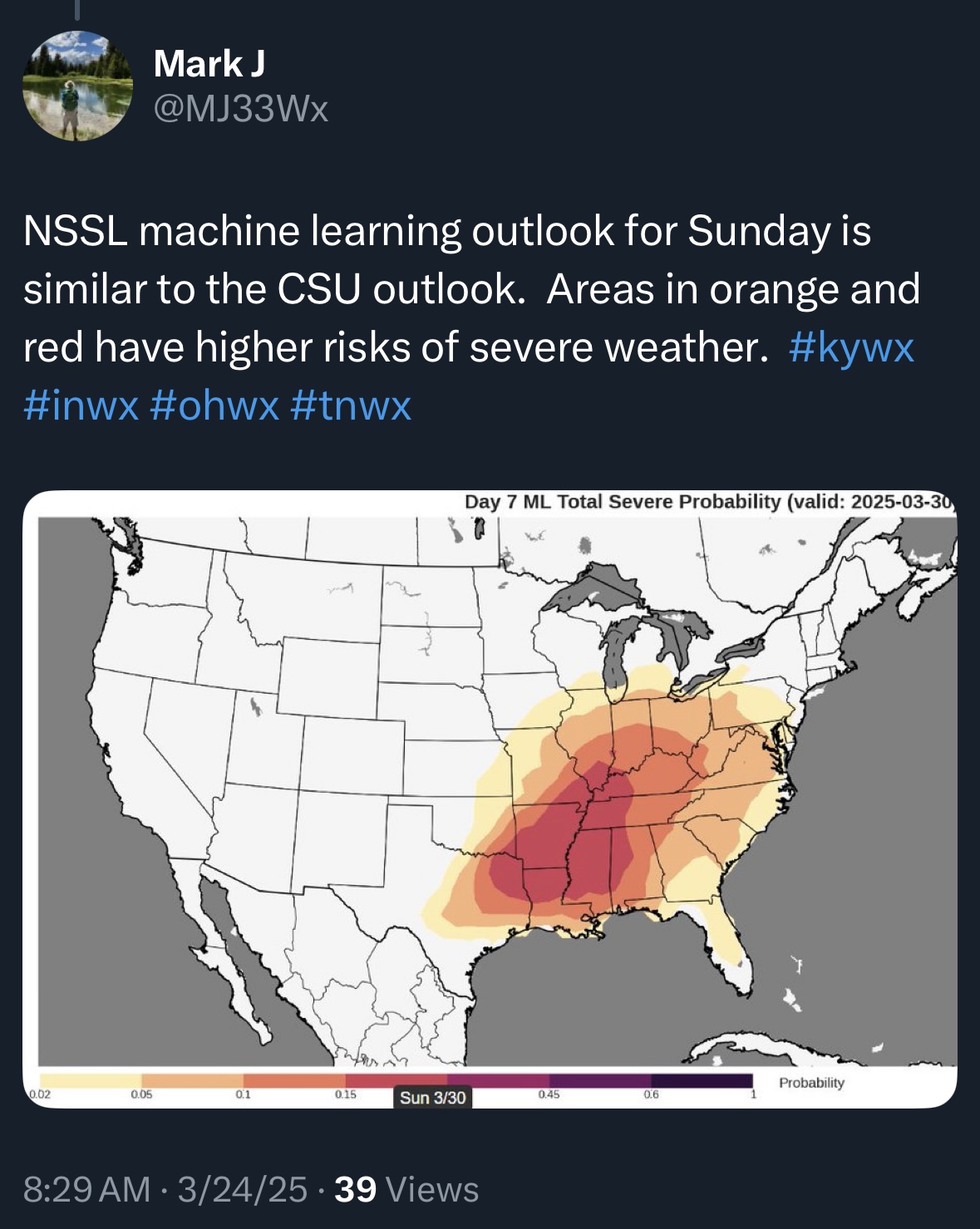
Looks like Saturday and Sunday are on the map. A couple of nots on this…. Looks like this week we will not have any real systems across the south to wipe clean the GOM. The active southern track has really benefited the region and kept the juicy stuff pinned down across the Deep South. #2) NCAA basketball tournament. I’ve always worried about a situation with 20k in an arena and the unthinkable happens.


-
-
Historic Tennessee Valley Severe Weather Events
PowellVolz replied to Holston_River_Rambler's topic in Tennessee Valley
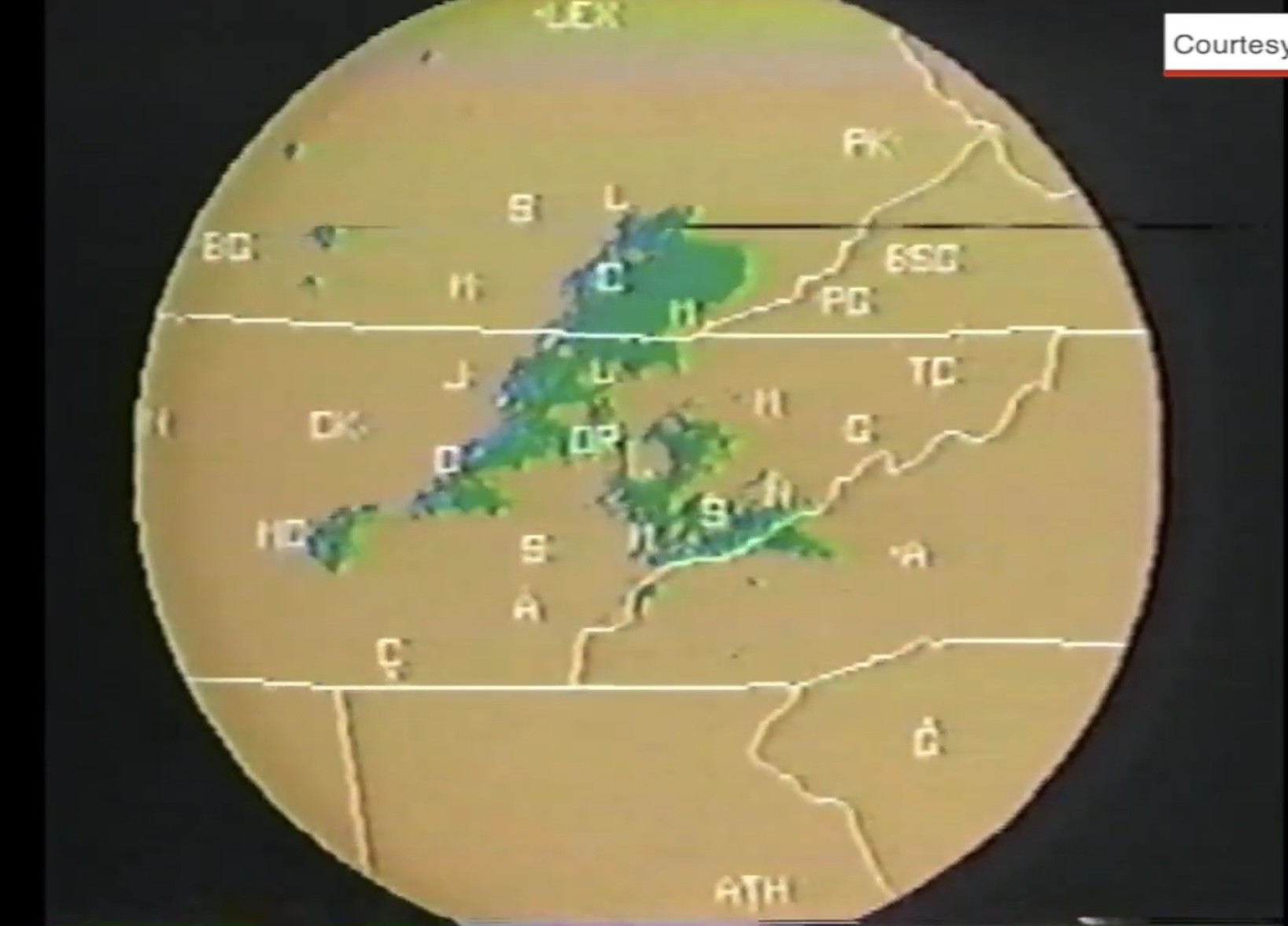
Found this video yesterday from the 93’ tornado across ETn. The one that went through Powell went right across my house but luckily no damage. 1/4 mile away Broadacres was messed up. FYI… this is still the strongest record tornado in Knox County an F3 at the time. a couple of pics… Lenoir City tornado…. and this one got me… the radar WBIR was using then… my Atari had better graphics IMO. Lol

- 4 replies
-
- 2
-

-
- tornado
- severe storms
- (and 2 more)
-
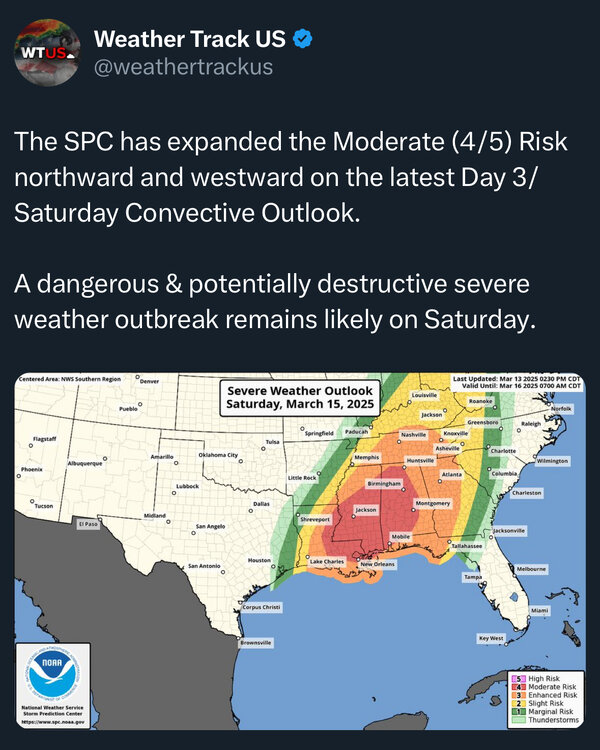
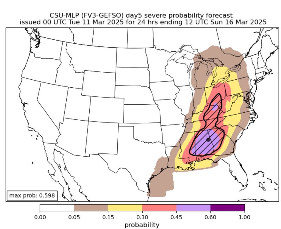
Mod risk moving north. Not surprised
-
It’s gonna be a close call but some of the mods are showing a break Saturday morning across MTn. Will also be interesting to see what happens in SE Tennessee up to Knoxville. This area could potentially get a longer rain free break after 12 noon. The LLJ really kicks in after 6pm in the valley. I won’t be surprised at all to see lots of wind damage reports from non thunderstorm wind gusts.
-
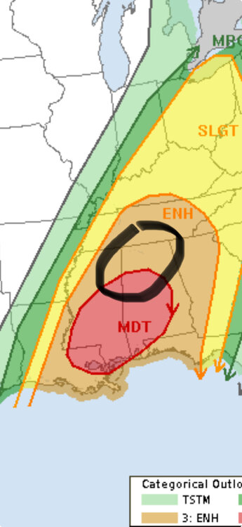
As of now IMO here’s where I think the greatest risk of tornadoes will be Saturday. This is contingent on a mostly rain free warm sector. When the CAM’s come into range, we will then be able to see where potential boundaries are that’s been left over after the morning convection. I won’t be surprised at all if the moderate and enhanced risk is moved north. A high risk doesn’t really matter at this point and I’m not sure it’s warranted until we get to Saturday morning and see what the radar looks like.
-
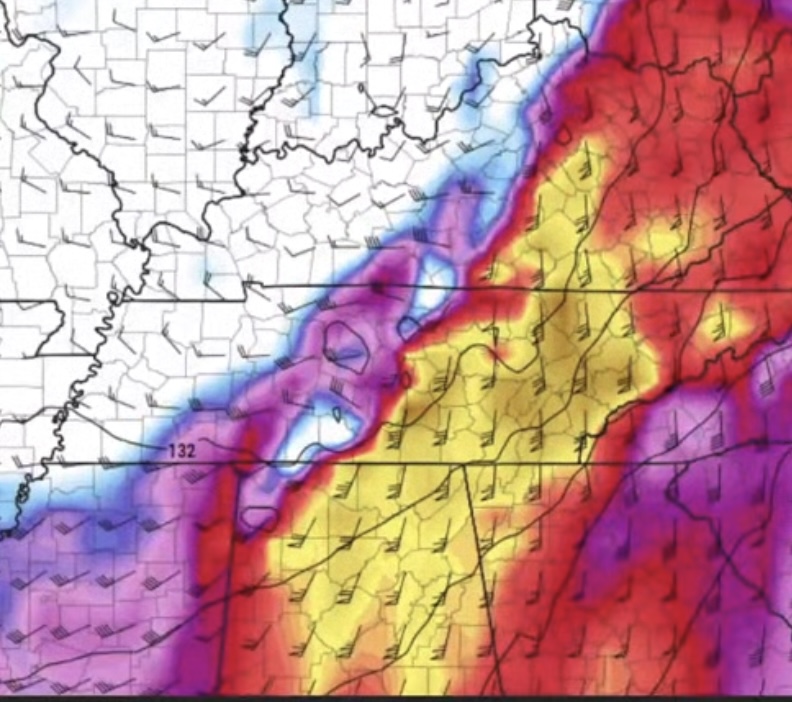
Mods are now showing less morning convection, especially to the south of Tennessee. Less clouds and showers are a result of a stronger EML and a little less forcing which is more confined to the cold front/dry line. The main issue for Tennessee, especially MTn to ETn is how quick does the warm front and elevated convection get north of Tennessee. A warm sector like this only needs 5 to 6 hours of rain free and broken clouds to recover. The trough looks a little flatter which means a little more zonal flow aloft. That typically leads to more of a discrete mode and less heavy rain. IMO…. This is looking worse the closer we get. Moisture transport won’t be a problem with the LLJ running more south to north which also gives a little more convenience degree when the LLJ interacts with the storms. This is the LLJ between 6pm and 10pm Saturday afternoon. You only need around 30mph or so of LLJ to help rotate storms. This LLJ is running 50-70mph.
-
kinda of a catch 22. The potential lack of moisture for Friday that the mods are now showing could mean less convection Friday/Friday night which could potentially allow for more moisture return on Saturday. However the mods are also showing a little less zonal flow and more 500mb winds running parallel to the CF. More zonal flow, more discrete cells. More parallel winds, more of a QLCS or squall line. Something to watch.
-
Mods are showing a secondary surface low pressure developing around the Arkletex region and tracking NW between Nashville and Jackson. I’m not gonna say what this setup reminds me of but i think it’s pretty dang close.
-
Guys…… we better hope that little short wave trough moving across the south on Wednesday clears out the GOM or we will have a problem
-
Cove Mt in Wears Valley had sustained winds of 57mph and recorded a gust to 97 around 11:45pn when the station went dead.
-
You getting anything frozen now? Radar is looking like it.