
Mrwolf1972
-
Posts
797 -
Joined
-
Last visited
Content Type
Profiles
Blogs
Forums
American Weather
Media Demo
Store
Gallery
Everything posted by Mrwolf1972
-

January 15th-17th 2024 Arctic Blast/Snow Event
Mrwolf1972 replied to John1122's topic in Tennessee Valley
From Facebook nws post 1/15/24 12:00am HRRR simulated radar solution seems to be spot on with timing tonight, with the Tri-Cities and northern valley expected to see widespread snow showers begin over the next hour. I wanted to include the forecaster’s discussion from the NWS for those that enjoy reading the take from the local office in Morristown. For those that don’t want to read the full text, there’s a couple of key items: 1) expect forecast totals to be increased by the overnight crew as current trends with early accumulation support the more robust solutions we’ve been watching over the past couple of days 2) there will be a brief, anticipated lull from around 4am until 8-9am after which the bulk of the heavier precipitation begins to move in and increase throughout the day tomorrow. An interesting phenomenon, and something I haven’t seen in a long time with a winter storm set up in our area, is watching the HRRR and NAM both capture a “trapping” of the precipitation on our side of the Appalachians. Typically we see lower Valley accumulations and increased totals along the higher elevations of our NC border counties. There’s a distinct accumulation cut off from the foothills of our border counties and the higher elevations. I would anticipate some of the precipitation “stalling,” and potentially increasing accumulation in the Central Valley. It sets up a rare situation where valley accumulations will be potentially higher than that of our mountain locations. As some of you get up and ready for work tomorrow, be sure to pay attention to any forecast adjustments and monitor live radar before heading out the door. The forecasted “pause” will likely be during the typical rush-hour period. Don’t be lulled into a false sense of security. Sent from my SM-S916U1 using Tapatalk -
January 15th-17th 2024 Arctic Blast/Snow Event
Mrwolf1972 replied to John1122's topic in Tennessee Valley
I'd say we will have about 12 hrs of good snow fall starting after day break here in the valley probably will get our snow then if the models are correct. Anyone agree Sent from my SM-S916U1 using Tapatalk -
January 15th-17th 2024 Arctic Blast/Snow Event
Mrwolf1972 replied to John1122's topic in Tennessee Valley
They said there would be lulls the heavier stuff is yet to come Sent from my SM-S916U1 using Tapatalk -
January 15th-17th 2024 Arctic Blast/Snow Event
Mrwolf1972 replied to John1122's topic in Tennessee Valley
Looks like the heavier snow will set up in valley around 9am and stay there all day hope that pans out. Sent from my SM-S916U1 using Tapatalk -
January 15th-17th 2024 Arctic Blast/Snow Event
Mrwolf1972 replied to John1122's topic in Tennessee Valley
The 06z hrr shows a 3 to 4 hrs lull then it cranks back up state wide heavy band in the valley. Sent from my SM-S916U1 using Tapatalk -
January 15th-17th 2024 Arctic Blast/Snow Event
Mrwolf1972 replied to John1122's topic in Tennessee Valley
My dew point down to 21 south loudon temp 36 Sent from my SM-S916U1 using Tapatalk -
January 15th-17th 2024 Arctic Blast/Snow Event
Mrwolf1972 replied to John1122's topic in Tennessee Valley
Radar filling in to the west Sent from my SM-S916U1 using Tapatalk -
January 15th-17th 2024 Arctic Blast/Snow Event
Mrwolf1972 replied to John1122's topic in Tennessee Valley
My dew point and temperature are dropping in Loudon finally. Sent from my SM-S916U1 using Tapatalk -
January 15th-17th 2024 Arctic Blast/Snow Event
Mrwolf1972 replied to John1122's topic in Tennessee Valley
So all models are on board but nam correct? Sent from my SM-S916U1 using Tapatalk -
January 15th-17th 2024 Arctic Blast/Snow Event
Mrwolf1972 replied to John1122's topic in Tennessee Valley
21z rap Sent from my SM-S916U1 using Tapatalk -
January 15th-17th 2024 Arctic Blast/Snow Event
Mrwolf1972 replied to John1122's topic in Tennessee Valley
18z GFS looks like the 18z hrr to me up to 39 hrs Sent from my SM-S916U1 using Tapatalk -
January 15th-17th 2024 Arctic Blast/Snow Event
Mrwolf1972 replied to John1122's topic in Tennessee Valley
18z. GFS upped totals Sent from my SM-S916U1 using Tapatalk -
January 15th-17th 2024 Arctic Blast/Snow Event
Mrwolf1972 replied to John1122's topic in Tennessee Valley
I have been in the 40s all day in loudon when will the cold air begin moving in the valley. Sent from my SM-S916U1 using Tapatalk The cold air seems to be stuck on the plateau. -
January 15th-17th 2024 Arctic Blast/Snow Event
Mrwolf1972 replied to John1122's topic in Tennessee Valley
It just seems weird 95% of the models look the same but 2 both that are sagging south for us not to get a win. Sent from my SM-S916U1 using Tapatalk -
January 15th-17th 2024 Arctic Blast/Snow Event
Mrwolf1972 replied to John1122's topic in Tennessee Valley
Rdps Sent from my SM-S916U1 using Tapatalk -
January 15th-17th 2024 Arctic Blast/Snow Event
Mrwolf1972 replied to John1122's topic in Tennessee Valley
18z icon Sent from my SM-S916U1 using Tapatalk -
January 15th-17th 2024 Arctic Blast/Snow Event
Mrwolf1972 replied to John1122's topic in Tennessee Valley
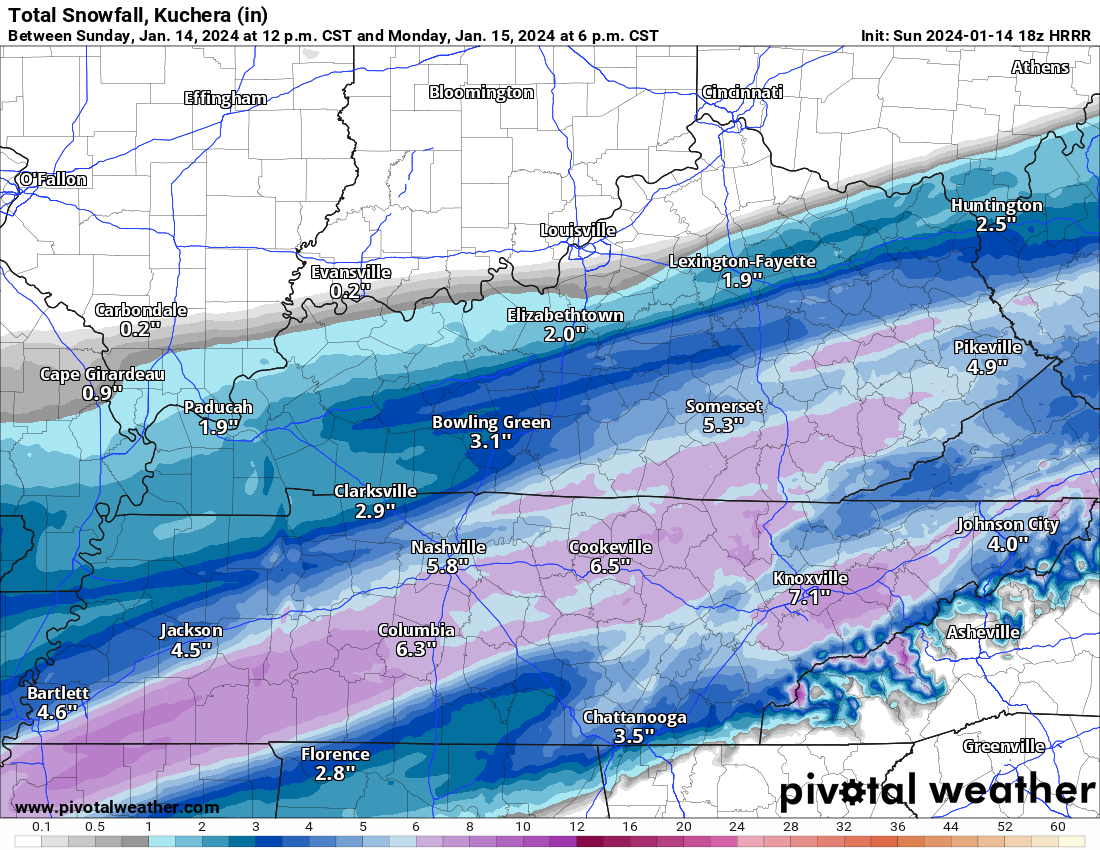
6-8 inches knoxville and 4-6 loudon new totals from nws -
January 15th-17th 2024 Arctic Blast/Snow Event
Mrwolf1972 replied to John1122's topic in Tennessee Valley
19z hrr slows the system down its slower then the 18z -
January 15th-17th 2024 Arctic Blast/Snow Event
Mrwolf1972 replied to John1122's topic in Tennessee Valley
18 z nam is still too warm rain and sleet not much snow. its still on a island of its own plenty of snow west and middle nothing much east tn -
January 15th-17th 2024 Arctic Blast/Snow Event
Mrwolf1972 replied to John1122's topic in Tennessee Valley
looks like the 18z nam has dropped south from recent runs -
January 15th-17th 2024 Arctic Blast/Snow Event
Mrwolf1972 replied to John1122's topic in Tennessee Valley
18z hrr Sent from my SM-S916U1 using Tapatalk -
January 15th-17th 2024 Arctic Blast/Snow Event
Mrwolf1972 replied to John1122's topic in Tennessee Valley
southern border counties have some ice accumulations chatt has .10 accum -
January 15th-17th 2024 Arctic Blast/Snow Event
Mrwolf1972 replied to John1122's topic in Tennessee Valley
18z pops a low next to Ashville and keeps snowing @34 hrs -
January 15th-17th 2024 Arctic Blast/Snow Event
Mrwolf1972 replied to John1122's topic in Tennessee Valley
18z hrr @ 30 hrs still snowing
-
January 15th-17th 2024 Arctic Blast/Snow Event
Mrwolf1972 replied to John1122's topic in Tennessee Valley
hrr 18z totals are going to be high its been snowing the whole run so far out to 24