Diggiebot
-
Posts
187 -
Joined
-
Last visited
Content Type
Profiles
Blogs
Forums
American Weather
Media Demo
Store
Gallery
Everything posted by Diggiebot
-
Ef3 homes torn apart
-
Have you been watching the web cam and chaser vids? They are all showing cat 4 conditions easily. Not sure what you are looking at. Also I’m sure the worst of this wasn’t even caught on video. Storms this bad make it hard to capture. Video cuts out and communication is lost.
-
LOL just what we need in this ever-changing cluster of a forecast. More changes and surprises to come for sure!
-
Groton ct. it’s alomst due north of Montauk
-
I was 5 and it’s probably one of my first memories from growing up. I followed my dad outside during the peak. The wind was absolutely crazy! It’s why I love following weather today!
-
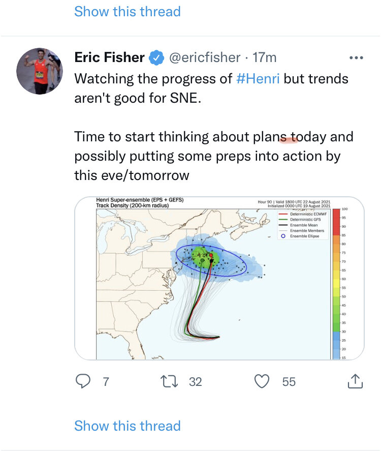
I think eastern tip of LI to buzzards bay will be the red zone for this one. The euro and gfs both have this and the hurricane models as well. I think we get some more ticks west today then corrections back east on Saturday.
-
I think it’s cold water draining down from the gulf of Maine plus North Carolina deflects the Gulf Stream out to sea
-
I think it’ll be shifted to a canal to Westport landfall at 11pm
-
We know at some point close to the wire there will be a slight jog back east messenger style. It’s good to move it west now so we really lock in this strike. Hugging the outer cape is a recipe for a last minute agonizing miss like Edouard.
-
Euro has this stall and loop from the outer cape to the middle of CC bay down to the vineyard and across Nantucket then east ots between hours 84 and 135. That’s super long duration for tropical. That would be a coastal flooding nightmare for se ma
-
Strengthening is key for the western solutions so def good to see
-
Headed right between the islands and over the mid cape it looks like? Could turn right in future frames tho.
-
In honor of James I gatta throw in the Gulf Stream comment. SST’s are rocking off the east coast. Henri is going to hit those waters and be primed for intensification. Miss your forum presence Jimmy! Maybe Henri is headed straight to harwich cape cod mass!
-
It looks like a canal to RI mean with a stall and exit east type track
-

2021 Atlantic Hurricane season
Diggiebot replied to StormchaserChuck!'s topic in Tropical Headquarters
Your a Debbie. Winter spring summer and fall we get it. -
Also caught a 40 lb halibut and our boat limit of 12 total. Highly recommend Alaska it was so beautiful.


-
Alaska fishing trip in late July. We should have salmon like this up in Maine and NH. Hopefully conservation efforts bring them back at some point. We caught 18 salmon on the Kenai river near Soldotna.

-
If anyone is due its New England. Nada since Bob in 1991. We are going on 30 years with a return of 20 years for a land falling hurricane. Add all the coastal development and it’ll be a doozy even if it’s a minimal storm. Bob is the storm that got me hooked on weather. I was only 5 and I can still remember it. I followed my dad outside in the peak of the storm. My mom was not happy at all.
-
10 Year Anniversary. June 1 2011-2021. Monson Springfield MA
Diggiebot replied to HoarfrostHubb's topic in New England
I actually just drove 20 through Brimfield a few weeks back. You can see the newer lower trees coming down the mountains and hills and it’s still pretty clear where the tornado went over 20 too. The untrained non weather person would have no idea now tho. Everything in the path has that lime green younger leaf growth look. -
10 Year Anniversary. June 1 2011-2021. Monson Springfield MA
Diggiebot replied to HoarfrostHubb's topic in New England
It was a 4 and Worcester ‘53 was a 5. Grazulis was pretty clear on that one. -
I’m just glad he got winter 2005, 2015 and the 2019 tornado. Lots of optimistic storms and hurricanes that James wouldn’t give up on in between. A James hurricane or winter storm will be fitting in the next year or two for sure!
-
https://www.capecodtimes.com/obituaries/p0106302 Sad news. James Nichols passed away.
-
I don’t get this it doesn’t happen in New England mantra on this forum. Everyone acts like once in 100 years is the New England norm. It’s really not though we are in a hurricane drought that will end at some point. 30 years without a hurricane is a long time. Please stop acting like we don’t get hurricanes because it will happen.
-
March 12/13/14 Blizzard/Winter Storm/WWA etc
Diggiebot replied to Bostonseminole's topic in New England
This was caused more by super low ratio slush snow....we get nor’easters with winds 65+ with minimal outages. This was more about the heavy weighted snow.