

EB89
-
Posts
235 -
Joined
-
Last visited
Content Type
Profiles
Blogs
Forums
American Weather
Media Demo
Store
Gallery
Everything posted by EB89
-
It’s now misting in Leesburg.
-
Frederick schools are closing 3.5 hours early tomorrow.
-
I hope but I’ve seen this movie twice this year. Hoping for a solid north trend that doesn’t materialize. Something is better than nothing at this point.
-
Love that WSW cutoff right at the Frederick/Moco border
-
I may have missed it but can someone post the Euro map please?
-
Best rates and flake size I’ve seen in quite a long time. Visibility keeps decreasing
-
Those bands about to come through Frederick look nice
-
Definitely in a lull
-
Cul-de-sac caving
-
Sidewalks are getting that slushy look. At the 15/26 interchange in Frederick.
-
All snow finally. Starting to stick to cars and grass
-
Rain/snow mix with more snow mixing in the past couple minutes.
-
Snow lulled but picking back up and largest flakes of the storm so far.
-
First flakes in Frederick at the 15/26 split.
-
HRRR didn’t look too bad up my way in Frederick. Can someone post kuchera please?
-
FCPS MD closed
-
The Weekend Rule? Saturday 2/17 - The Icon Storm
EB89 replied to DDweatherman's topic in Mid Atlantic
URGENT - WINTER WEATHER MESSAGE National Weather Service Baltimore MD/Washington DC 935 AM EST Fri Feb 16 2024 MDZ004-VAZ505-170000- /O.UPG.KLWX.WS.A.0005.240217T0000Z-240217T1200Z/ /O.EXB.KLWX.WS.W.0007.240217T0400Z-240217T1000Z/ Frederick MD-Western Loudoun- 935 AM EST Fri Feb 16 2024 ...WINTER STORM WARNING IN EFFECT FROM 11 PM THIS EVENING TO 5 AM EST SATURDAY... * WHAT...Heavy snow expected. Total snow accumulations of 3 to 6 inches. The highest totals are most likely under heavier snow bands and for elevations above 1000 feet where isolated totals to 8 inches are possible. * WHERE...In Maryland, Frederick MD County. In Virginia, Western Loudoun County. * WHEN...From 11 PM this evening to 5 AM EST Saturday. * IMPACTS...Travel could be very difficult. * ADDITIONAL DETAILS...Snowfall rates of 1 to 2 inches per hour are possible for a few hours under the heaviest snow bands. Visibility may be reduced to less than one half mile at times. PRECAUTIONARY/PREPAREDNESS ACTIONS... If you must travel, keep an extra flashlight, food, and water in your vehicle in case of an emergency. When venturing outside, watch your first few steps taken on steps, sidewalks, and driveways, which could be icy and slippery, increasing your risk of a fall and injury. && -
The Weekend Rule? Saturday 2/17 - The Icon Storm
EB89 replied to DDweatherman's topic in Mid Atlantic
Hazardous Weather Outlook Hazardous Weather Outlook National Weather Service Baltimore MD/Washington DC 938 AM EST Fri Feb 16 2024 MDZ003>006-503-505-507-VAZ025>031-036>040-050-051-501-502-505>508- 526-WVZ050>053-055-171445- Washington-Frederick MD-Carroll-Northern Baltimore- Northwest Montgomery-Northwest Howard-Northwest Harford-Augusta- Rockingham-Shenandoah-Frederick VA-Page-Warren-Clarke-Nelson- Albemarle-Greene-Madison-Rappahannock-Orange-Culpeper- Northern Fauquier-Southern Fauquier-Western Loudoun- Eastern Loudoun-Northern Virginia Blue Ridge- Central Virginia Blue Ridge-Northwest Prince William-Hampshire- Morgan-Berkeley-Jefferson-Hardy- 938 AM EST Fri Feb 16 2024 This Hazardous Weather Outlook is for portions of eastern West Virginia, northern and central Virginia, and central and western Maryland. .DAY ONE...Today and Tonight Winter Storm Warning and Winter Weather Advisories are in effect for tonight. .DAYS TWO THROUGH SEVEN...Saturday through Thursday The winter weather headlines continue through early Saturday. .SPOTTER INFORMATION STATEMENT... Spotters should be prepared to report snowfall measurements and observations of heavy snowfall rates. -
The Weekend Rule? Saturday 2/17 - The Icon Storm
EB89 replied to DDweatherman's topic in Mid Atlantic
Don’t know if this was posted yet.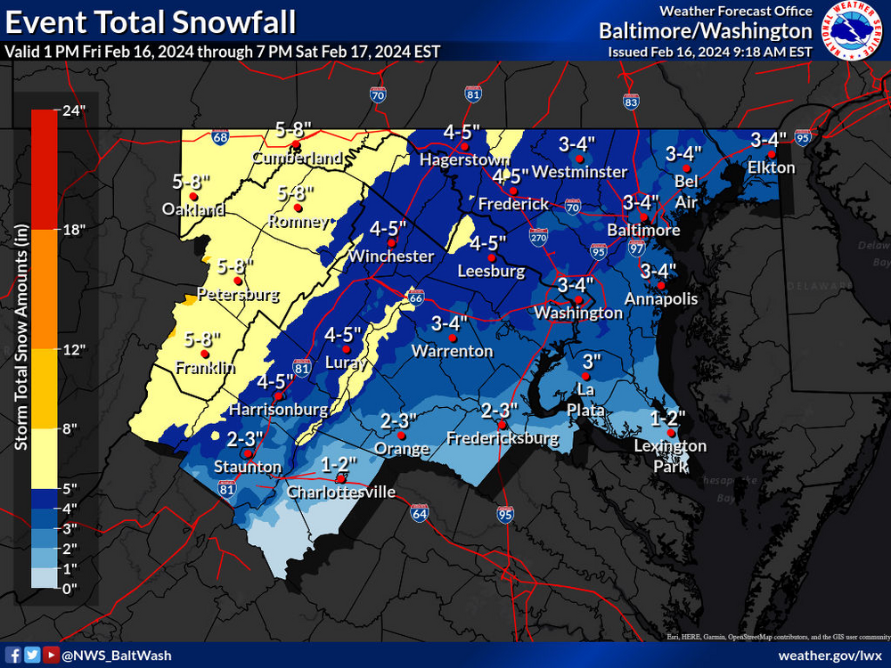
-
The Weekend Rule? Saturday 2/17 - The Icon Storm
EB89 replied to DDweatherman's topic in Mid Atlantic
WASHINGTON-FREDERICK MD-CARROLL-NORTHERN BALTIMORE-CECIL- CENTRAL AND EASTERN ALLEGANY-NORTHWEST MONTGOMERY- NORTHWEST HOWARD-NORTHWEST HARFORD-AUGUSTA-ROCKINGHAM-SHENANDOAH- FREDERICK VA-PAGE-WARREN-CLARKE-RAPPAHANNOCK-NORTHERN FAUQUIER- WESTERN LOUDOUN-EASTERN LOUDOUN-CENTRAL VIRGINIA BLUE RIDGE- NORTHWEST PRINCE WILLIAM-MORGAN-BERKELEY-JEFFERSON- 600 PM EST THU FEB 15 2024 ...WINTER STORM WATCH IN EFFECT FROM FRIDAY EVENING THROUGH SATURDAY MORNING... * WHAT...HEAVY SNOW POSSIBLE. TOTAL SNOW ACCUMULATIONS OF 2 TO 4 INCHES ARE MOST LIKELY, WITH THE POTENTIAL FOR LOCALIZED TOTALS OF UP TO 6 INCHES UNDER HEAVIER SNOW BANDS. * WHERE...PORTIONS OF CENTRAL, NORTHERN, AND WESTERN MARYLAND, NORTHERN AND NORTHWESTERN VIRGINIA, AND EASTERN WEST VIRGINIA. * WHEN...FROM FRIDAY EVENING THROUGH SATURDAY MORNING. THE STEADIEST SNOW IS MOST LIKELY FROM LATE FRIDAY EVENING THROUGH THE PRE-DAWN HOURS EARLY SATURDAY MORNING. * IMPACTS...PLAN ON SLIPPERY ROAD CONDITIONS. THE HAZARDOUS CONDITIONS COULD IMPACT THE FRIDAY EVENING COMMUTE WEST OF INTERSTATE 81. * ADDITIONAL DETAILS...SNOWFALL RATES OF 1 TO 2 INCHES PER HOUR ARE POSSIBLE FOR A FEW HOURS OVERNIGHT FRIDAY NIGHT UNDER THE HEAVIEST SNOW BANDS. VISIBILITY MAY BE REDUCED TO LESS THAN ONE HALF MILE AT TIMES. PRECAUTIONARY/PREPAREDNESS ACTIONS... MONITOR THE LATEST FORECASTS FOR UPDATES ON THIS SITUATION -
Finally de-icing.
-
SWA
-
Been sitting on a plane for 3 hours now.
-
Loudoun government closed.
-
Drive from Frederick to DCA was fun. Roads caved quickly. Hoping flight stays on time.


