Wurbus
-
Posts
550 -
Joined
-
Last visited
Content Type
Profiles
Blogs
Forums
American Weather
Media Demo
Store
Gallery
Everything posted by Wurbus
-
December 2020 Medium/Long Term Pattern Discussion.
Wurbus replied to John1122's topic in Tennessee Valley
-
December 2020 Medium/Long Term Pattern Discussion.
Wurbus replied to John1122's topic in Tennessee Valley
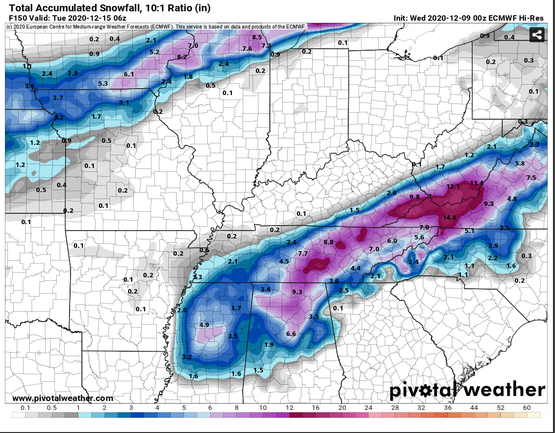
Looks like CMC holds the energy back a little bit and it winds up phasing a little later. Not as big as a hit for mid/west TN as the last run. Looks like East TN gets some wrap around snow as the low travels up through East TN again. -
December 2020 Medium/Long Term Pattern Discussion.
Wurbus replied to John1122's topic in Tennessee Valley
CMC had an odd run. Develops the low along the front around Christmas and it comes up through east TN. I would think middle TN would score with that look. Although, at this point, it is an outlier. -
December 2020 Medium/Long Term Pattern Discussion.
Wurbus replied to John1122's topic in Tennessee Valley
I think we need a Christmas miracle! -
December 2020 Medium/Long Term Pattern Discussion.
Wurbus replied to John1122's topic in Tennessee Valley
A long way to go, but it appears GFS is the new Dr. No. Now that I think about it, this totally makes sense in the year 2020. -
December 2020 Medium/Long Term Pattern Discussion.
Wurbus replied to John1122's topic in Tennessee Valley
12z GFS was about the same through 132 as the 00z and 06z. On to the CMC and Euro. Will be interesting to see which model caves first. -
December 2020 Medium/Long Term Pattern Discussion.
Wurbus replied to John1122's topic in Tennessee Valley
2 runs in a row for the Euro. What could go wrong a week out?! Seriously though, I think we mentioned this time frame as something to watch about a week ago, so pretty awesome something is still showing up to watch.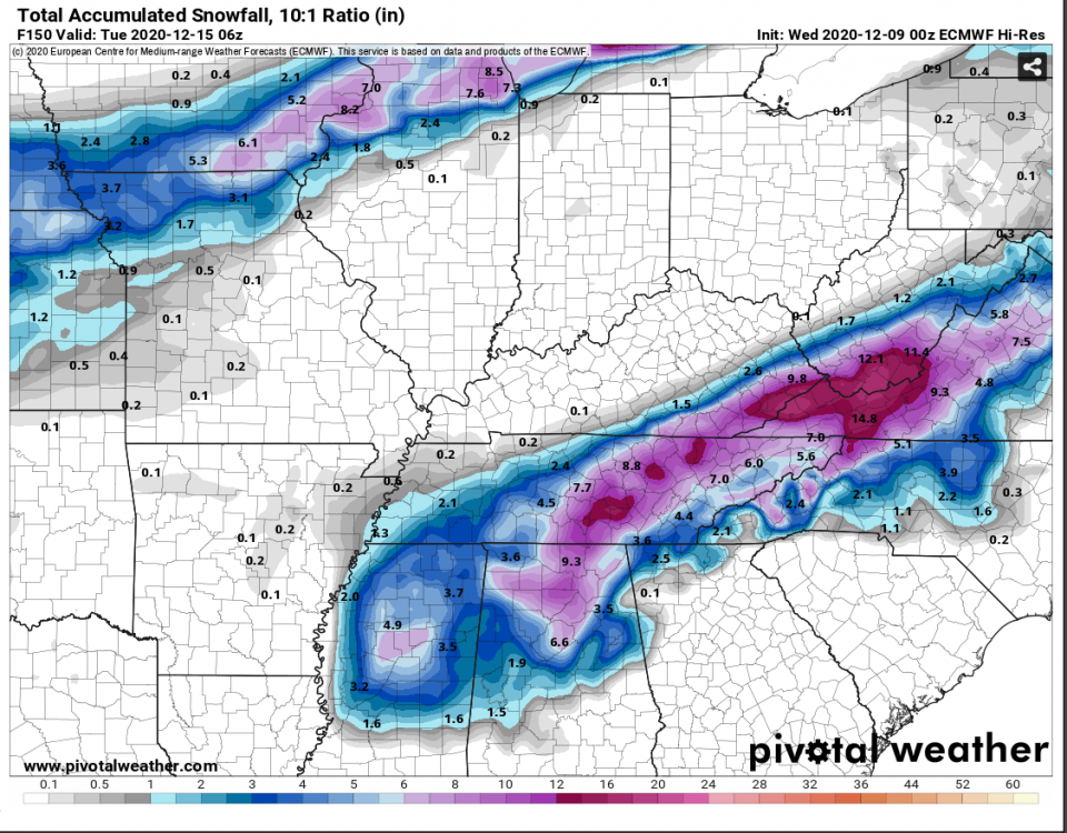
-
December 2020 Medium/Long Term Pattern Discussion.
Wurbus replied to John1122's topic in Tennessee Valley
I'm not sure where to post this, but looks like the HRRR was updated.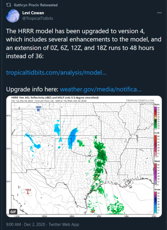
-
December 2020 Medium/Long Term Pattern Discussion.
Wurbus replied to John1122's topic in Tennessee Valley
It is fantasy land, but what a beauty at the end of that GFS run. It has been hinting at something around mid-December. It is at least a window to watch. It is also followed by some bone chilling cold.
-
Oak Moon Upslope/ Upper Low Storm Obs
Wurbus replied to Holston_River_Rambler's topic in Tennessee Valley
Been having light snow/flurries for about an hour now near Karns. I can see it just starting to stick on some of the grassy surfaces. Will be pretty white out here soon at this rate!- 300 replies
-
- 2
-

-
- upslope snow
- upper level disturbance
- (and 3 more)
-
December 2020 Medium/Long Term Pattern Discussion.
Wurbus replied to John1122's topic in Tennessee Valley
Thanks John. I was just on my phone looking and saw it earlier. -
December 2020 Medium/Long Term Pattern Discussion.
Wurbus replied to John1122's topic in Tennessee Valley
GEFS snow mean looked juicy! -
December 2020 Medium/Long Term Pattern Discussion.
Wurbus replied to John1122's topic in Tennessee Valley
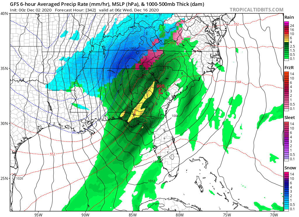
That low just gets cutoff over Michigan and spins for days. If that happens, some of those totals in MI are going to be insane, especially with lake effect snow. -
December 2020 Medium/Long Term Pattern Discussion.
Wurbus replied to John1122's topic in Tennessee Valley
Euro has the Nov 30th/Dec 1st system cutting up through Nashville with some plateau/mountain love and flurries/light snow for most of East TN after it moves through. Looks to be chilly, regardless of precip. -
Fall/Winter Banter - Football, Basketball, Snowball?
Wurbus replied to John1122's topic in Tennessee Valley
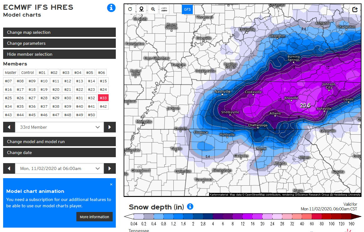
1st weenie run of the season!! Courtesy of EPS member #33. I actually thought this was rain at first because it was so big!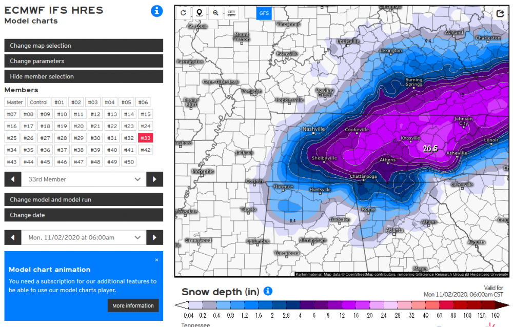
-
Not sure where to post this, but it is an interesting read on how forecast accuracy is down due to less flights because of COVID. https://www.cnn.com/2020/07/18/weather/fewer-flights-covid-weather-forecast-hurricane-impact/index.html
-
TYS actually tied the record low of 39 this morning.
-
Cole Sullivan, from WBIR, tweeted that there are still 77 people missing in Putnam county. This is awful news and I'm praying for everyone that was affected in these storms!
-
February/March 2020 Winter's Last Chance Thread
Wurbus replied to John1122's topic in Tennessee Valley
GEFS had a few members that were pretty big hitters the first week of March. -
NAM vs the Euro cage match storm, Feb 20 - 21
Wurbus replied to Holston_River_Rambler's topic in Tennessee Valley
Big, fat flakes have stopped now off Lovell Rd and it is a lighter snow coming down. Grass, trees, & cars are white. Nothing on the roads or sidewalks here. -
NAM vs the Euro cage match storm, Feb 20 - 21
Wurbus replied to Holston_River_Rambler's topic in Tennessee Valley
Been ripping fatties for the past 10mins off of Lovell road & Dutchtown. Grass is starting to turn white. -
NAM vs the Euro cage match storm, Feb 20 - 21
Wurbus replied to Holston_River_Rambler's topic in Tennessee Valley
Plumes for Knoxville went down .07 qpf for the mean and went back down to around 2 inch average in snow totals. -
NAM vs the Euro cage match storm, Feb 20 - 21
Wurbus replied to Holston_River_Rambler's topic in Tennessee Valley
Pretty good increase on the GEFS mean for this system at 18z. For reference, there was no blue in TN on the 12z mean outside a very small sliver in NE TN.
-
February/March 2020 Winter's Last Chance Thread
Wurbus replied to John1122's topic in Tennessee Valley
Very nice increase in the plumes for Knoxville. Went from 1/2 inch mean to 1 inch mean, including one big dog and several more showing more than the 15z -
February/March 2020 Winter's Last Chance Thread
Wurbus replied to John1122's topic in Tennessee Valley
It's looking like it will start in East TN Thursday morning (6-9am-ish), so the majority of it would be during the day on Thursday, but I'm not 100% sure. It is always difficult to determine the timing on the models for me.