Wurbus
-
Posts
550 -
Joined
-
Last visited
Content Type
Profiles
Blogs
Forums
American Weather
Media Demo
Store
Gallery
Everything posted by Wurbus
-
Me waiting on the ice accumulation map to load on pivotal for CMC

-
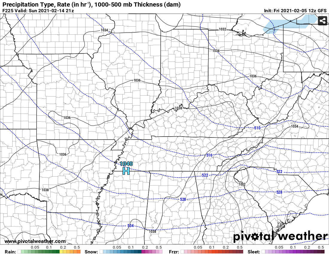
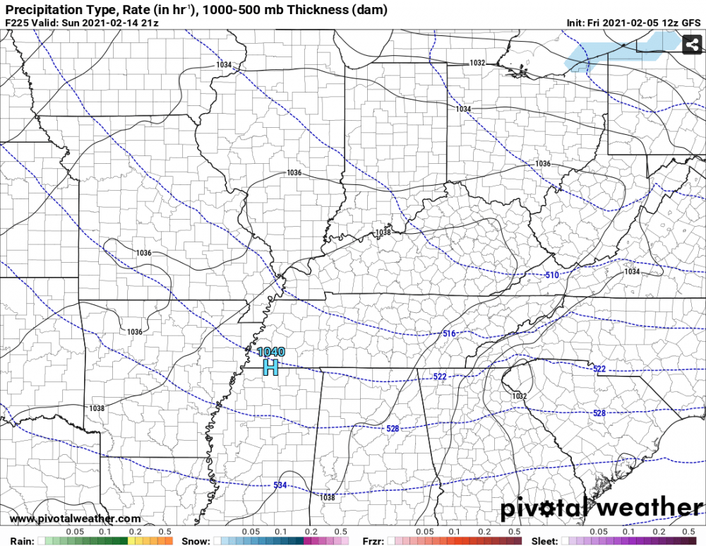
Y You don't see a 1040 HP sitting over Memphis everyday.....
-
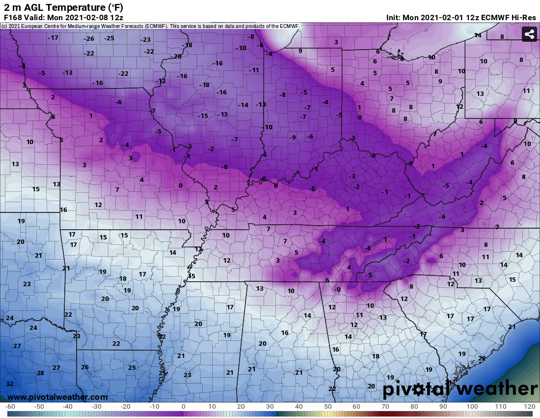
It is no joke. Just looking at Knoxville, we are in the single digits and negatives for 30+ hours. Nashville was pushing 40 hours.
-
Yeah, looks like it could possibly be single digit highs and lows in the negatives for much of the region!
-
Those ice maps have to be beyond epic in Georgia. Looks like ice for 36+ hours in some spots.
-
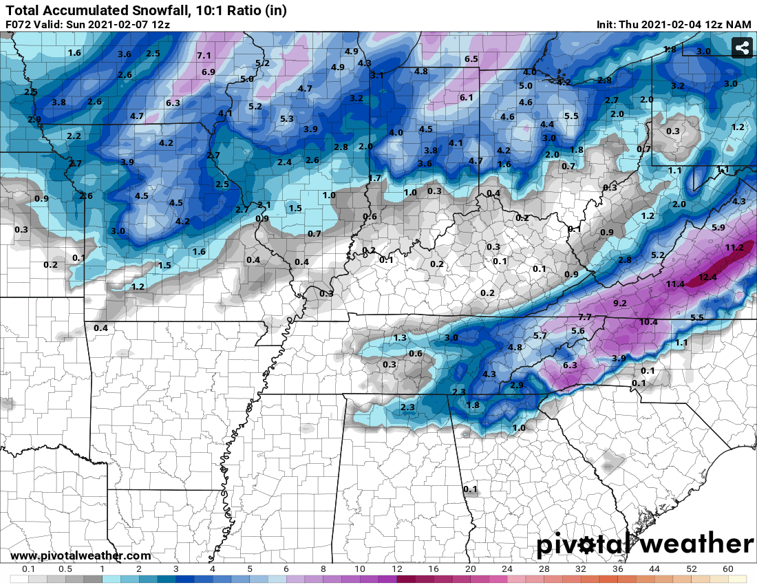
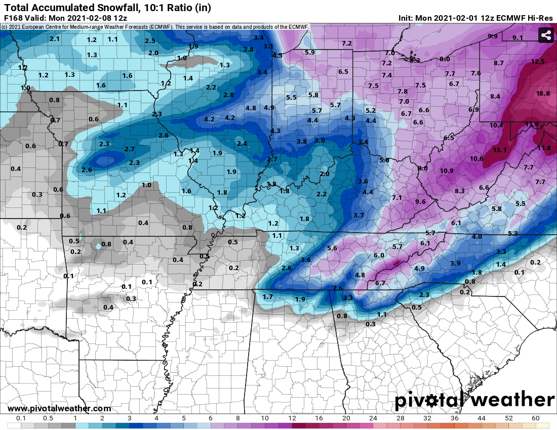
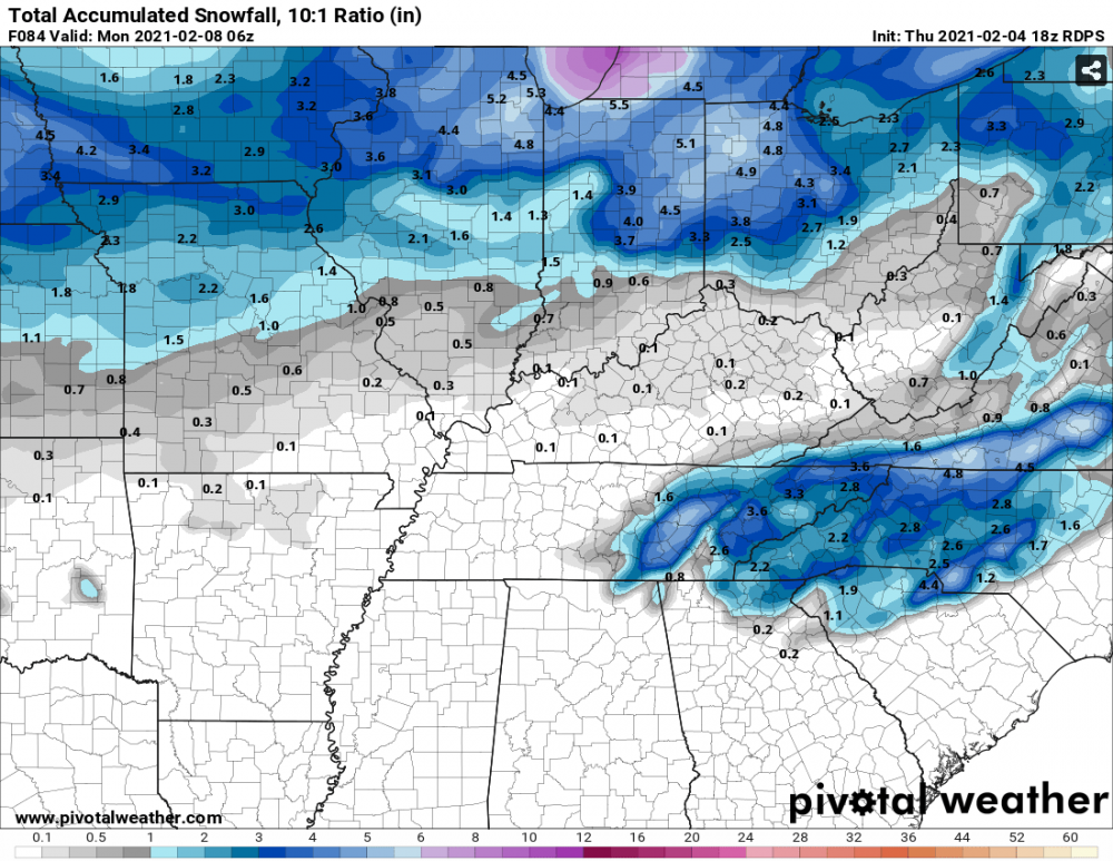
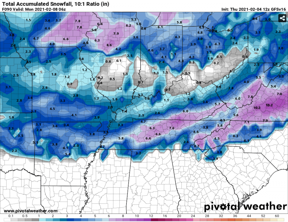
Euro more suppressed and colder toward next weekends 1st storm. Not as amped. 2nd storm appears to have more energy and hass one hell of an ice storm in south Georgia. Starts at 204 and is still going at 222. Some moisture is starting to reach TN by 216. I don't have any ice maps, but I'm sure it would be devastating in that area. East TN does get some snow toward the end of the run from the 2nd system. Probably 3-6 inches for all of East TN.
-
-
Another good Nam'ing. Looks to start Saturday evening, so the timing should be good.

-
Most GEFS Members are on board with something as well.
-
Looks like CMC precip shield is a bit more north compared to 00z, but the moisture still doesn't reach the TN valley. Fascinating to see these 2 different camps right now on each run. I think Carvers mentioned a few days ago that the phasing was just hours apart and I think that is what we are seeing with these model runs.
-
Para-GFS GFS
-
RGEM says what weekend storm?
-
Nam'd
-
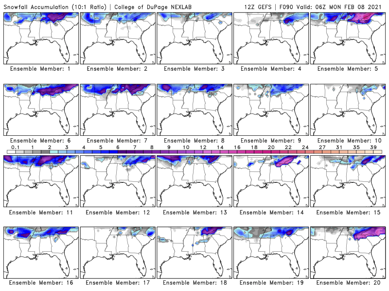
I was just looking at the SREF Plumes as well. Knoxville went from 1 member showing snow to 5 showing an inch or more.
-
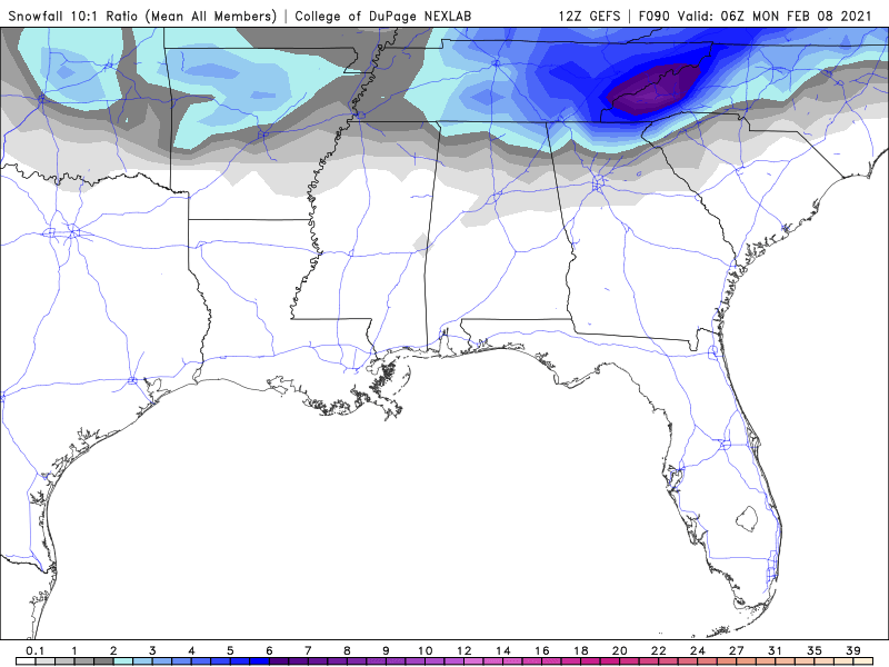
Not sure if it means all that much at this point, but there are still 4 GEFS members that still have the weekend storm showing snow in our area.
-
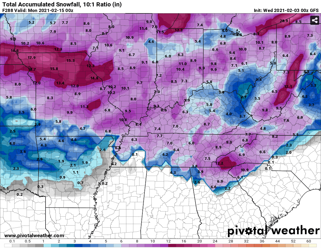
Nice hit for the deep south on Valentine's weekend. Atlanta would be wrecked on that run.
-
I would take the uber dry run if we could lock in the storm it has on Valentine's Day. CMC also has a little storm for East TN toward the end of it's run.
-
And for good measure, below is MRX's discussion tonight. AREA FORECAST DISCUSSION National Weather Service Morristown TN 619 PM EST Mon Feb 1 2021 .UPDATE... FOR 00Z AVIATION. && .DISCUSSION... Quick update to Beef PoPs up a bit mainly north in portions of the winter weather advisory area given the latest trends and high resolution model output. Otherwise, previous forecast still looks to be on track. && .AVIATION... 00Z TAF DISCUSSION. Will see snow showers and flurries at times especially TRI and TYS tonight, but these will decrease and end from southwest to northeast later tonight/Tuesday. MVFR conditions for the most part tonight although lower conditions to IFR (or even lower) will certainly be possible in heavier snow showers especially TRI. Clouds will break up with VFR conditions arriving first at CHA by early Monday and then TYS and eventually TRI during the day. Winds will generally be from the northwest and west 8-12kts with a few higher gusts. && .PREV DISCUSSION... /ISSUED 336 PM EST Mon Feb 1 2021/ SHORT TERM...(Tonight through Tuesday)... An upper low continues to slide east across the central Appalachians at this time fostering deepening cyclogenesis along the eastern seaboard. Closer to home across East TN and southwest VA/NC, deep nwly flow packing plenty of moisture (thanks to the GLC) continues to spill into the region. With that, scattered to numerous snow showers will become increasingly focused on the high terrain of the Cumberland Plateau and the southern Appalchians, with the most efficient snowfall favored across East TN and southwest VA given enhanced orographic lifting. This overall synoptic pattern will persist through the overnight into/through Tuesday morning before deeper moisture advection wains leading to a slow decline in precipitation production along the terrain, at least through Tuesday afternoon. This will favor lowering pops amidst continued mostly cloudy skies through Tuesday morning with some scattering of clouds later in the period. Low temperatures tonight will fall into the 20s for all locales outside of the high terrain where values in the teens are favored. High temperatures on Tuesday will peak a few degrees higher than today given marginally improved insolation and less evaporative/dynamic cooling as precipitation coverage decreases in the valley. Details on snow totals and any other hazards below. For the plateau, expecting the current lull in activity to end later this evening as another piece of vort energy advects southeast across the region. Therefore will expand the current Winter Weather Advisory across the Plateau through 1AM ET. Snowfall will likely persist beyond this timeframe, but the most significant accumulations should end. Looking at the valley, along/north of I40 cannot rule out an occasional snow shower drifting downstream from the northern Plateau and the Black Mountains of KY. This could result in some light accumulations (an inch or less) with Black Ice being an additional concern given temperatures in the 20s amidst wet roadways. Further north along the I81 corridor into southwest VA, accumulations will be slightly higher with a couple inches possible, highest for elevations above 2500ft such as High Knob VA where snow totals could exceed 4 inches or so. As stated above, the heaviest accumulations still look to reside along the East TN mountains where upslope flow will be greatest. Totals for the mountains remain in the 4-6 inch range for elevations around 3kft, with totals increasing sharply to 8-12 inches above 4kft, possibly as high as 14- 16 inches above 5kft. Lastly, would like to stress that totals across the Plateau and especially in the valley are event totals which are impacted by melting through the event given warm ground temperatures. Thus these totals may not reflect accumulations at any given time. LONG TERM...(Tuesday Night through Monday)... Key Points: 1. Mostly dry and seasonally cold to start the period with moderation to near normal temperatures on Thursday. 2. Precipitation chances return Thursday night into Friday with some changeover to snow possible Friday night. 3. Low confidence for potential snowfall Saturday into Sunday. 4. Very cold temperatures arrive Sunday into Monday with wind chills below 0 in the higher elevations Sunday night. Tuesday Night through Friday At the start of the period, the system currently impacting the area will be centered along the New England coast. This comes with mid/upper ridging west of the Mississippi River and 1,025mb surface high pressure centered over the upper Mississippi River Valley. This setup provides a continuation of northerly/northwest flow with deep moisture having progressed off to the east. Nevertheless, indications of low-level moisture below 850mb will keep low-end chances for lingering flurries and light snow showers in the mountains. Otherwise, the main weather factor will be cold temperatures, combined with persistent winds due to a notable MSLP/low-level height gradient. While radiational cooling will be limited, synoptically-driven CAA and subsidence will allow for temperatures to drop well-below freezing and into the teens in the higher elevations. Wind chills near 0 are possible in the TN mountains with values in the teens likely elsewhere. On Wednesday, high pressure dominates with continued northerly flow keeping temperatures relatively cool. For Wednesday night into Thursday morning, the next system of interest develops via cyclogenesis on the leeward side of the central Rockies. This comes in association with a deepening shortwave out of Saskatchewan/Manitoba and a phase lag between this trough and the thermal (1,000mb-500mb thickness) trough. Mid/upper ridging moves to the east and leads to height rises locally. These height rises and increasing southerly flow ahead of the next system provide WAA and a recovery of temperatures to near normal for Thursday. Confidence remains lower for the timing, track, and evolution of the surface low into Thursday night, but the overall consensus is for a track into the Great Lakes Thursday night with the associated cold front moving through the area on Friday morning. The GFS is more aggressive with CAA and lingering moisture with the CMC and ECMWF suggesting only light snow showers on the back edge. Nevertheless, PoPs are highest into Friday morning with continued uncertainty for the rate of changeover to snow on Friday. Saturday through Monday For the end of the period, confidence in another chance for snow remains low with decently high confidence for very cold temperatures by the end of the period. All deterministic and ensemble model guidance shows deep, anomalous mid/upper troughing in the east by Sunday with Arctic high pressure moving in from the Northern Tier. The GFS and CMC deterministic both suggest chances for light snow Saturday into Sunday morning from upper-level jet divergence with the ECMWF suggesting a surface low to develop in the Gulf and track to our south. The ECMWF solution is the outlier, however, as ensembles all point towards only light snowfall potential outside of northwest flow in the mountains. Nevertheless, ensemble solutions point towards 500mb height anomalies of -20 dam or lower with deterministic guidance showing anomalies near record-breaking levels of -40 dam or lower. For 850mb temperatures, values to -10 to -20 degrees Celsius continue to look likely across the area within all ensemble and deterministic guidance. At any rate, well-below normal to potentially record-breaking temperatures are expected with higher chances for the latter if a snowpack develops prior to the arrival of the Arctic high. Based on the consensus of low-level temperatures and MSLP gradients ahead of the Arctic high, wind chills below zero are likely in the mountains with single-digits a possibility area- wide into Monday morning. Also, multiple days of subfreezing temperatures are likely in many parts of the area. Due to continued uncertainty for snowfall and ongoing weather, HWO wording will be left out again with addition possibly needed on later shifts.
-
I believe below is what Winterstorm is referring to. Area Forecast Discussion National Weather Service Nashville TN 539 PM CST Mon Feb 1 2021 .UPDATE... FOR 00Z AVIATION DISCUSSION. && .DISCUSSION... Snow has decreased in coverage this afternoon, but another lobe of the upper trough looks to dive southward later this afternoon and evening, giving the Plateau a shot at additional snow accumulation. Consensus shows the highest elevations between 1 to 2 inches, and around a half inch to an inch elsewhere in the winter weather advisory area. Extended the advisory through midnight, but snow may continue into the early morning hours Tuesday. Rest of the I-65 corridor up to the Plateau could see some flurries, so another dusting is not out of the question. Tuesday and Wednesday look to be dry as the upper trough slowly moves eastward. By Thursday, a Midwest trough will bring a cold front through the Plains and towards the mid state. Chances for rain will ramp up later in the day Thursday and especially Thursday night. Temps look warm enough right now that most of the precip will be rain, with a slight chance for some snow to mix in the northwest Friday morning. Models are quick to dry things out behind the cold front during the day Friday, so started backing off pops during the day Friday and Friday night. The next trough for Saturday late in the day and Saturday night may bring a shot at some light rain and snow, along with additional CAA behind the previous cold front. Models have been consistent showing this colder air for a few runs now, and show 850 mb temps around -24C Sunday evening. This would give us lows in the teens Monday morning, and highs during the day Sunday only in the 20s. The next big trough may be Tuesday/Wednesday of next week, and models are surprisingly consistent this far out with upper level features and even the surface low. With cold air already in place, a trough develops in the southern Plains and tracks eastward. This trough would bring Gulf moisture northward, with a nice overrunning/isentropic lift snow event if model solutions pan out. Right now models place the warm front right through the mid state, so it could even be snow north of I-40, rain in northern AL, and a mix in between. Still a lot that can change between now and then, including abandoning the trough entirely, so dont count on heavy snow just yet. But with the potential cold late this weekend, and a potential heavy snow setup next week, winter isnt releasing its grip anytime soon!
-
Euro after that storm. BRRRRR!!!


-
Jan 11-12 Mississippi Mauler: Will it or won't it?
Wurbus replied to John1122's topic in Tennessee Valley
Ironic I've already got more snow (A dusting on my deck) than I did last Friday under a WWA. -
January 7 - 8 ULL obs and nowcast
Wurbus replied to Holston_River_Rambler's topic in Tennessee Valley
A pretty, light snow has finally started falling at my house near Karns in Knoxville. I doubt we will get much more than a dusting here, but at least it is pretty to watch coming down. -
January 2021 Medium/Longterm Pattern Discussion.
Wurbus replied to AMZ8990's topic in Tennessee Valley
I'm also posting the GEFS mean. It has been awhile since I have seen Knoxville in the purple/pink for the mean.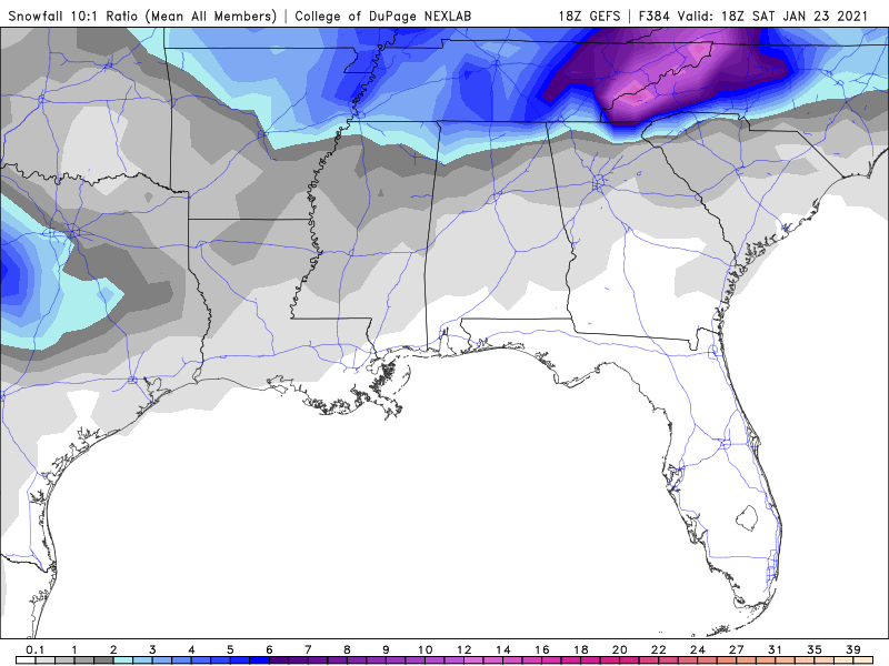
-
Can we cash that NAM run in right now and call it a winter? I feel like we have already have had more storms to track this winter than the past 2-3 combined!
-
January 2021 Medium/Longterm Pattern Discussion.
Wurbus replied to AMZ8990's topic in Tennessee Valley
GFS was a miss on the 1st system. Just missing moisture in East TN.