

downeastnc
-
Posts
9,324 -
Joined
-
Last visited
Content Type
Profiles
Blogs
Forums
American Weather
Media Demo
Store
Gallery
Everything posted by downeastnc
-
RAH put out a good map that shows what kind of low and track do well for NC.....
-
Yeah that's in MBY so yeah not happening.....every year we get a couple of runs that look like 1980 or 1973 they never happen......still with the setup something sort of like this is certainly on the table somewhere in the SE....
-
Red Sox won the WS and now the Pats are SB bound.....got a lot of folks to hit up at work tomorrow that talked a lot of smack, going to be a good day.
-
Generally for us in eastern NC anyways it seems like the models never really pick up on the threat in a meaningful way until its 5-7 days out.....there is potential in the models after Jan 20th.
-
Yeah very rare....1980 was ZR/sleet to start with temps in the mid 30's before temps crashed into the teens with SN+........the 12Z GFS takes PGV from 43 and rain to 23 and heavy sleet/snow in one frame. Would indeed be absolutely insane to see a 20 degree temp drop in 6 hrs after precip started.....FV3 even more ridiculous temp of 60 to low 20's in 6 hrs....I would give anything to see this actually happen.... HR
-
ULL are fun but frustrating....models tend to do pretty badly with them as far as how intense they can be....like several have mentioned some big snows have happened in NC due to a ULL dropping in like this.....you just never know what they will do for sure. No one should expect more than say 1-2" but there could easily be a few spots that win out and get over that.....
-
I will take the 18Z NAM 3k.....obviously overdone as it has a heavy "band" of snow just sitting over central eastern NC..... but I need it to be right.....
-
The FV3, ICON and HRRR all have something similar to lesser degrees....temps will be a problem and overall it probably wont be a big deal but some models do put down a few inches....
-
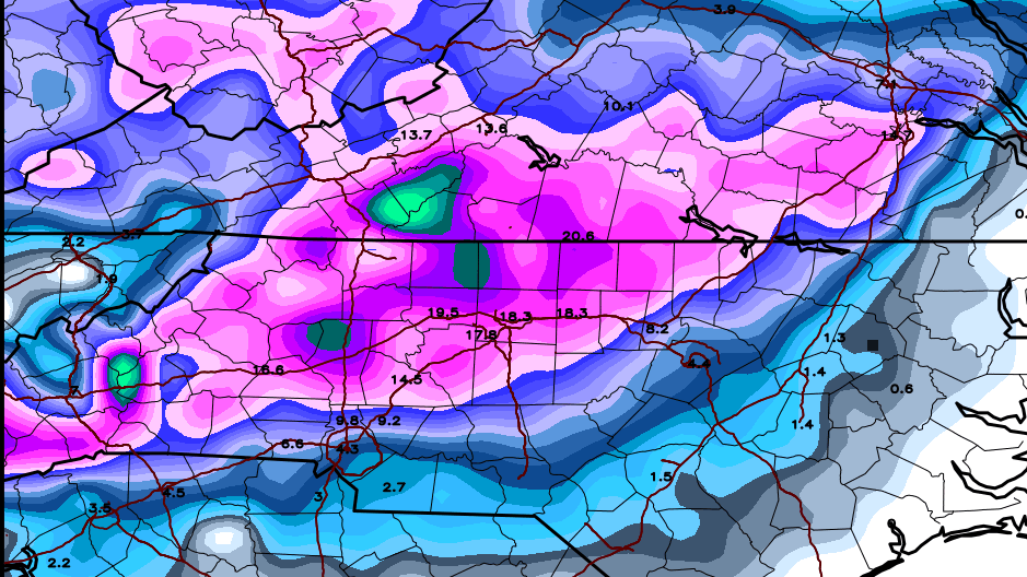
GFS 24 hr snowfall for the second system.....this shouldnt include anything from today
-
Thats the thing, a few degrees one way or the other is gonna be huge for many people....even down my way a few degrees colder aloft and we could get several inches or more of snow/sleet. The flip side to that though is a few degrees warmer aloft and its sleet on top of above freezing surface temps well inland.....and all rain for us eastern folks. Need the suppressed track to win out, can not have the low right off the coast that never works out well for anyone other than the deep inland foothill areas.
-
Problem is the temps at the surface are 33-35 for most of that...according to that it even MBY would be sleet/snow most of the storm though with temps just above freezing...so might be one of those times where we get a quick 2-4" of slop with the heavy rates before it lighten up and goes to cold rain......
-
The high placement on the last frame is classic NC snowstorm placement and the snow coverage reacts accordingly......just need the next 2-3 frames now.....
-
Colder and snowier much further east.....now if it will just go ENE from there instead of reforming off the NC coast we would be looking at a bigger event for central and eastern NC but that little jump north kills us.....
-
PGV is 32/18 last frame of the NAM, track kills us though need this thing to stay heading ENE the entire time that turn up the coast is gonna cause problems well inland if it happens....
-
Yeah going NE up the coast from SAV is going to do bad things.....the only people that cash in on that track are the foothill/mts.....the rest of us need a later phase or better yet a slow moving OTS track with a phase well off the SE coast....that track is gonna give the Triad etc ptype issues if it pans out.
-
The one good thing is this thing cant really bust for me.....I would be sweating bullets if I was in the spots showing 12-24" every run.....we had a similar storm forecast down here a few years back, run after run of the Euro and GFS giving us 12-20" in central and eastern NC on the clown maps.....ended up with 3" of sleet......better to expect rain or a slushy 1-2" and get a foot than think your getting the big dog and ending up with tons of sleet. Seriously though if the cold can trend stronger the track should trend flatter and then snow totals would climb in central and eastern NC.....seeing some signs of that on the NAMS etc but still several days to go to hash it out.
-
The jump north with the SLP at 126 on the FV3 is a killer for central and eastern NC, it it just kept ENE from the hr 120 plot the totals from RDU down my way etc would be much higher....
-
Then get use to it cause this is how it is every single time a storm comes around in the SE forum........the same core group post the same way every single model run.......with gaggles of lurkers asking MBY questions......it is what it is.....
-
LOL......you don't have to read the threads this is how we roll in the SE forum we are much less uptight than the folks from other forums......I suggest rolling with the punches or visiting the Sanitarium thread.....or going back to the NYC/MA forums since your in NJ.
-
Yeah the whole " you never wanna be in the bullseye 7 days out yada yada yada"....those MA folks probably thinking they have this one right where they want it in the 7-8 day range......the FV-3 track is money until the low gets captured and tugged back into the sounds.........
-
GFS holding onto the cold front next weekend followed by a period of highs in the 50's low 60's and low well into the 40's.....
-
00Z GFS was better highs in the 50's week of Oct 15th which also happens to be first week of rifle season on deer......keeps MBY under 60 for 4 straight days, please let that happen lol....
-
That tornado warning by Oxford the real deal......decent couplet there
-
That onshore firehose band is pummeling areas just south of me....its raining like crazy here and the returns are greens and yellows those areas from Havelock to New Bern to Kinston are just getting hammered.....
-
Everything coming in off the ocean is spinning right now....probably going to be a problem today and even tomorrow


