

SteveVa
-
Posts
355 -
Joined
-
Last visited
Content Type
Profiles
Blogs
Forums
American Weather
Media Demo
Store
Gallery
Everything posted by SteveVa
-
I'm staying up for the Euro again...this hobby makes me so unproductive in the winter 00z Canadian still looks good for the areas NW of the metro. It performed pretty good with the last event two weeks ago so I'll pay a bit more attention to it. 00z GFS went suppressed/flatter again for the first wave. I like that...keep it suppressed until 48-72 hrs out. What I really like about the upcoming pattern is that it's not a one shot deal. Cold is there and pac shortwaves are entering CONUS every 2-3 days. I firmly believe we're bound to get snow from at least one of them. EDIT: 00z Euro out to hr 126...flatter wave, looks good for a light event. I realized I don't have to do PBP because you can gauge the situation by the main MA thread. Usually we're happy when they aren't and vice versa - they're not happy about the Euro. Also, I take my words back...still snowing in Tidewater at 156. RIC metro gets fringed. This is it from me tonight, I won't ruin this nice run by waiting for the EPS to bring me back to reality lol
-
12z Euro...first wave bombs out off Ocean City, would be snow-rain-dryslot-back end flurries for Tidewater. Second wave looks better, seems like it will dig more at hr 180. Let's let it play out though
-
00z Euro brings the goods. First wave(Dec 29) amplified and verbatim yields a nice snowstorm for both metro areas. Not gonna look at the clown snowfall map, but it should be 6-10" area wide. Second wave (Dec 31/Jan 1) is also not bad. another 6-10" north of the NC/VA border. Now if this was 40 hours out instead of 140 and 240...
-
@RIC Airport I agree with everything you said. ORF is pretty similar to RDU as far as climo goes though. I wish there were more active members from our areas on the forum considering the population. Fun times ahead. EPS was very kind to us today. Hopefully we can continue the theme of weakening the SER and pushing systems farther south. This far east, I can't rely on CAD too much.
-
There are at least dozen members from the Hampton Roads area...at least from what I saw during the Jan 6-7 blizzard. They're just not that active when it's not snowing, I guess. We definitely "belong" to the SE forum, but sometimes I feel out of place since is mostly Central NC/Upstate SC/North GA centric. That's why I usually post in the MA forum. Hope they're gonna take us in as refugees In other news, a beautiful winter day today. Sunny, 47 degrees.
-
36 degrees and light rain. There was a burst of snow at the beginning, rates did overcome for a couple of minutes! lol Seems like lower Eastern Shore could pick up a coating as well as middle peninsula. If the moisture had tracked just 20-40 miles more south MBY would probably get a coating too. Onto tomorrow night's possible flurries...
-
So close, but so far! Temperature down to 39 here in Virginia Beach. I can confirm some frozen precip mixing in with the rain using the black jacket test
-
The December to Remember 7th-8th blue turd winter threat thread.
SteveVa replied to lilj4425's topic in Southeastern States
Fool me once, shame on NAM; fool me twice, shame on me. NAM comes in juicier and warmer. We'll see will it fail or score a coup. -
The December to Remember 7th-8th blue turd winter threat thread.
SteveVa replied to lilj4425's topic in Southeastern States
There should be a "you've been NAM'd" button next to the like button 00z NAM out to 60, depicts nice cold rain -
The December to Remember 7th-8th blue turd winter threat thread.
SteveVa replied to lilj4425's topic in Southeastern States
Agree. Verbatim snow totals are much better for our area this run (2-3" for Southside) I got warm nose'd back in Jan which slashed my totals in half. I don't like that we have to rely on dynamic cooling. -
The December to Remember 7th-8th blue turd winter threat thread.
SteveVa replied to lilj4425's topic in Southeastern States
For folks in VA Beach...time to hug IBM's model! Courtesy of Michael Ventrice's tweet.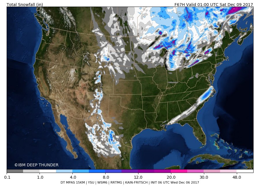
-
The December to Remember 7th-8th blue turd winter threat thread.
SteveVa replied to lilj4425's topic in Southeastern States
Winter is back, feels good. Been a long since we dissected 84hr NAM and threw around Icons, brazillian and australian models -
The December to Remember 7th-8th blue turd winter threat thread.
SteveVa replied to lilj4425's topic in Southeastern States
The inevitable NW trend is doing me no good...losing hope I'll see flakes at all. Today's runs have been consistently trending warmer At least I'll get some rain, ORF only had about an inch of rain during Nov. -
I'll take that trace amount
-
I have a barbecue planned for this Sunday, it looks like some cold rain might delay it lol
