

SteveVa
-
Posts
355 -
Joined
-
Last visited
Content Type
Profiles
Blogs
Forums
American Weather
Media Demo
Store
Gallery
Everything posted by SteveVa
-
If the Tuesday storm misses DC this winter will really be the biggest tease in history. They probably had 100" of digital snow inside 7 days. I'm more interested in the follow up wave on Thur-Fri. EPS has a good signal for RIC metro into Hampton Roads.
-
34.3, some snow is still mixing with the rain. All in all just over an inch here in VB which brings the season total over 14".
-
Seeing some flakes mix in with the rain near Virginia Beach town center. Temperature has dropped from 41.7 at just after 3pm to 39.4.
-
R/S line is slowly moving into Hampton Roads metro, let's see if we can sneak in an inch of slushy snow. It's encouraging that RIC dipped below freezing as of 335pm while most models had temps between 33 and 35 at 20z. 41 in Virginia Beach, there is no precip now. North wind is gusting into the 30s
-
Updated zone forecast looks not too bad for SE VA and NE NC. HRRR isn't too inspiring, but... NCZ015-122000- Pasquotank- Including the city of Elizabeth City 1219 PM EDT Mon Mar 12 2018 .THIS AFTERNOON...Rain, breezy with highs in the mid 40s. North winds 15 to 20 mph with gusts up to 30 mph. Chance of rain near 100 percent. .TONIGHT...Rain and snow in the evening, then snow likely after midnight. Snow accumulation around an inch. Windy with lows in the lower 30s. North winds 15 to 25 mph with gusts up to 35 mph. Chance of precipitation near 100 percent. VAZ095-122000- Norfolk/Portsmouth- 1219 PM EDT Mon Mar 12 2018 .THIS AFTERNOON...Rain, breezy with highs in the mid 40s. Northeast winds 15 to 20 mph with gusts up to 30 mph. Chance of rain 90 percent. .TONIGHT...Rain and snow. Snow accumulation around an inch. Windy with lows in the lower 30s. North winds 20 to 30 mph with gusts up to 40 mph. Chance of precipitation 90 percent.
-
Yeah, I found that weird too. They might be thinking that a deformation band could crush us as the low deepens and moves away while colder air starts filtering in. I'm not buying that solution at all tonight, I'd like to see HRRR or RAP show something to that effect. I guess it's fair game from AKQ mets since it is a possibility, and that map serves mostly as the worst-case scenario. Edit: Well they just updated the afd, there is the answer Depending on how the low tracks, it is not impossible that areas of SE VA and NE NC see more snow Mon evening, but confidence in that is very low, thus the advisory is in effect only for portions of the Piedmont where thermal profiles are at least marginally favorable.
-
I've been following this threat for a while but I kept quiet since I didn't think it'll impact MBY lol. Today's NAM is sucking me in though... I'd set the bar at 2" for RIC and trace/coating for ORF. Gonna be tough to get accumulating snow since boundary layer seems very toasty with surface temps in mid 30s. At least the timing is getting better, it's supposed to be a Monday evening/night event for my neck of the woods now. AKQ also upped the totals area wide for their forecast snowfall graphic.
-
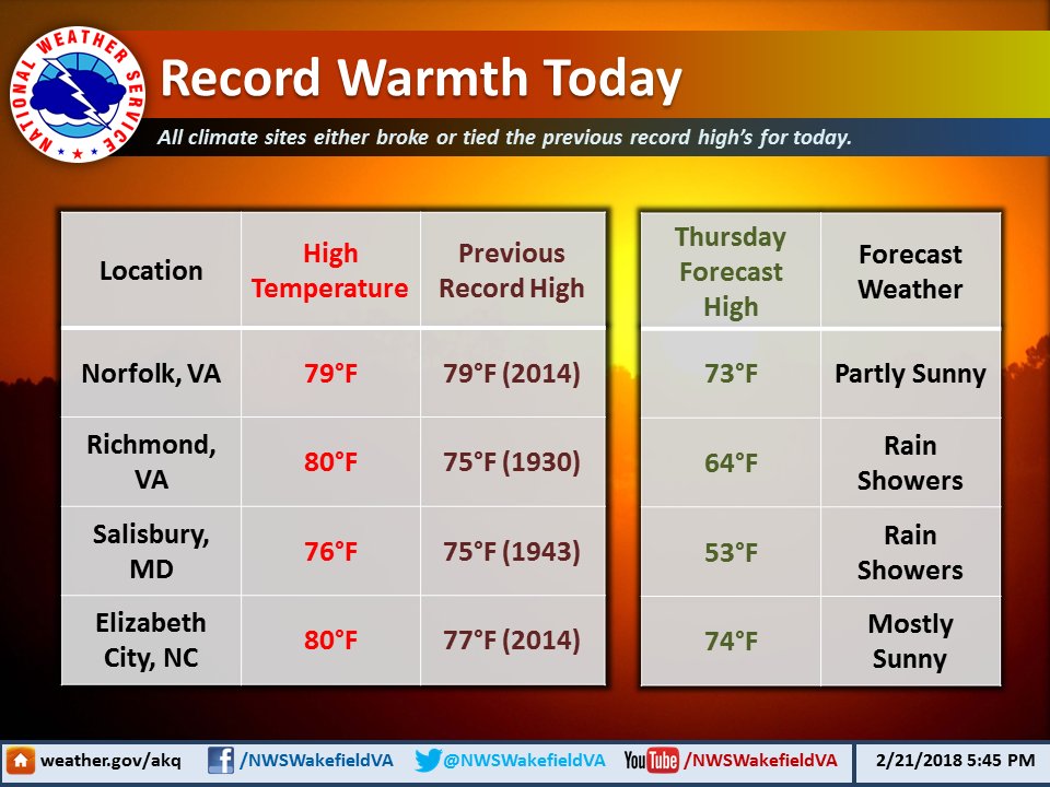
Record warmth in the region today
-
Last night's Euro is interesting, RIC gets a warning event. Day 7 certainly has potential if the cold press proves to be stronger than modeled (lol), we saw GFS spit out a southern solution yesterday that crushed NC.
-
I wouldn't be that negative...yet. We know that GEFS and EPS haven't been too reliable in the long range this winter, especially with the phantom SE ridge. I think the problem with this pattern is that Atlantic is not cooperating at all. And it's NS dominated. But that has been the problem throughout the winter. -EPO/+PNA can only do so much. I wouldn't stick a fork in the winter, but things look worse than they did about three days ago. In the end, ORF is sitting at 13.1" for the winter, I'd be greedy if I wanted more.
-
A burst of moderate snow in ORF. Visibility dropped under 1/2 mile. No real accums yet, just a slushy cartopper so far. 34 degrees
-
I'm wondering why is there absolutely no interest for tonight/tomorrow morning's event. I see that 00z NAM is even less impressed than 18z and has virtually nothing for RIC metro and Hampton Roads. Any flakes are a win in my book so it's worth tracking lol Even so, HRRRRR and RAP are keying on a stripe of 1" and even localized 2" from RIC metro into Hampton Roads. One thing I learned is to never discount those two models inside 12 hours since they do really well at sniffing out precip maxes. Worth saying that surface temps are in mid 30s and ground is warmish and wet so verbatim accums should be taken with a lump of salt. Also, both NAM and HRRRRRR show steep mid level lapse rates during the vort pass which leads me to believe that a band with locally heavy rates could set up as far south as NC/VA border. Pwats look to be around 0.4-0.5" in our area which seems decent...I think. I can't find upper level moisture maps on pivotalweather atmosphere should be nicely saturated up there. I'm still trying to learn more about all this and I would love if a met or someone more knowledgeable than me chimed in.
-
Time to bump the thread. Coating looks possible tonight and tomorrow, Feb 3rd front/wave isn't completely dead yet either, there is also a signal for a coastal somewhere around Feb 5/6. RIC needs just 2" more to finish the winter with AN snow, ORF already more than doubled climo. Looks like we're heading into a cold and stormy pattern...at least for the first part of Feb. Nice!
-
10" in Manteo and KDH according to the local met. Crazy, looks like HRRRRRR and RAP got it spot on. To recap the storm here...in general 2-4" for Hampton Roads with isolated 4"+ spots. Definitely better than most were expecting. The forecast only really busted for VA eastern shore where they got 4" (forecast was 1" at most) and extreme NE NC where they got 6" in ECG and Currituck Co as well as 10" on the OBX (forecast up to 3" and WSW was issued as the event was unfolding at 1am)
-
Bands seem to be blossoming just SW of the area. Just went for a nice, long jebwalk. It's just beautiful outside...about 2.5" on the ground. SPC says it's getting real for you @tramadoc tonight Mesoscale Discussion 0031 NWS Storm Prediction Center Norman OK 0909 PM CST Wed Jan 17 2018 Areas affected...The Outer Banks area of North Carolina into the Tidewater area of southeast Virginia Concerning...Heavy snow Valid 180309Z - 180715Z SUMMARY...Heavy snow rates in excess of 1 inch per hour, including occasional heavier convective bursts, may develop across the North Carolina Outer Banks area, possibly into portions of the Virginia Tidewater, during the 11 PM to 4 AM time frame. DISCUSSION...A significant mid-level trough is forecast to continue pivoting east of the southern Appalachians during the next few hours. As it does, models suggest that it may take on more of a neutral to negative tilt, accompanied by an increasingly better defined lower/mid tropospheric cyclonic circulation center across the piedmont through coastal areas. This appears likely to contribute to a consolidating area of upward vertical motion, with considerable strengthening by the 05-08Z time frame, centered across the Outer Banks area of North Carolina. Aided by dynamic cooling, cold advection and melting precipitation, thermodynamic profiles near immediate coastal areas are expected to cool entirely below freezing, supporting snow or a changeover to snow. Rapid Refresh forecast soundings indicate that lift may become maximized within the dendritic growth layer for several hours, supporting snow rates in excess of 1 inch per hour, in the presence of precipitable water between .5 and .75 inches. At least some convective enhancement appears possible leading to occasional heavier bursts of snow, before diminishing/spreading offshore after 08-09Z. It is possible similar snow rates could impact portions of the southeast Virginia Tidewater, but the most prolonged/heaviest snow appears most likely to the south, across the Outer Banks area near/north of Cape Hatteras. ..Kerr.. 01/18/2018
-
About 2" give or take on the ground near town center of VB. No precip currently but as the snow hole over the area is filling in I believe we'll be able to get another inch, or maybe 2" on the high end. This event will likely push the total for the season over a foot for ORF...or about 240% of climo. I give this winter an A-
-
Just about an inch down in Virginia Beach. Moderate snow, I bet we're getting some good ratios. We could easily push over 2", which is the latest official forecast. 27/26
-
3km NAM didn't really follow it up, has about 3-4" Just started snowing near town center of Va Beach. Let's get it. PWS shows 28.3
-
Wow at 18z NAM. Just wow. Easily 10" for PGV and ECG. About 6-8" for Va Beach and Norfolk
-
I use pivotal weather for the RAP, there might be a better site though http://www.pivotalweather.com/model.php?m=rap Be sure to select Kuchera ratio when checking snowfall amounts, you want that high ratio fix lol
-
Am I in that? LOL Yes you are. Verbatim 6" per 17z RAP... 12z NAM kinda crushed my hopes, but they're back up after a couple of good runs. I have to stop model watching, it's like a drug lol
-
16z HRRRRRR and RAP both show 4"+ for VB. Verbatim they have a 4"+ strip of snow from Ocracoke into Hampton Roads. NWS usually goes with a blend of those two models when forecasting inside 12-18 hours. It has gotta be hard right now for AKQ mets because most everyone here expects 2" at most. In other news, temperature is down to 31 degrees on the closest PWS. KORF is at 32 at 1pm. Mixing ain't happening.
-
Yeah, 12z NAM would be the worst case scenario. HRRRRRRR has been hinting in the past few runs that the coastal precip could sneak back into VB and Norfolk. Has about 7" of high ratio snow for Sandbridge lol. I might become more optimistic for our area if the event keeps trending slower... Currently 34 degrees and overcast. Official forecast calls for some mixing but obs say the whole column is below freezing besides the lowest couple hundred feet. I don't think mixing will be a problem after initial 15-30 mins of precip.
-
We're both in a sucky spot between to be honest. The band that slams Piedmont will likely dry up some and weaken by the time it reaches us. The coastal gets going too far east and slides quickly out to sea. You're in a better spot than I am for sure, there is a chance you get some of the coastal precip. I believe the rest of extreme NE NC still is in the game for a WSW criteria snow if the coastal develops just a tad sooner, MHX already pulled the trigger on the WSWs. Also, don't look at the 12z NAM, 0" for both of us while everyone else scores. Even Hatteras gets almost 6". We can hug the 13z HRRRRRRRRRR, dumps about 3-4" and still going at 2am
-
I was just about to post the discussion, that's pretty significant wording. The graphics they posted on Twitter note that Tidewater and NE NC could see up to 3"

