

BornAgain13
-
Posts
3,619 -
Joined
-
Last visited
Content Type
Profiles
Blogs
Forums
American Weather
Media Demo
Store
Gallery
Everything posted by BornAgain13
-
18z ICON and 18z GFS have a moderate to major ICE event for this weekend for northern NC/Southern VA
-
Is it possible to for the first system that it would trend colder with the HP and produce more ICE?
-
Models today showing an ICE storm for the CAD favored areas... Major ICE Storm at that per CMC. Central to Northern VA still look to be a lock for Significant Snow... To see that Big dog come in further south for the next system is intriguing...
-
12z ICON is a hair south... Major ICE Storm in the CAD areas in NC/VA.
-
Unless something trends better today, with the Euro being very consistent on that stripe of snow in central/N VA, I would think it would be a wintry mix/rain for most of everyone else... I hope it trends better today.
-
0z Euro is a Central VA and North special. That's where the consensus seems to be for the best snow for now.
-

Mid to Long Range Discussion ~ 2024
BornAgain13 replied to buckeyefan1's topic in Southeastern States
Good news on the 18z Euro. It did trend south from 0z. Lines up fairly close to the 18z GFS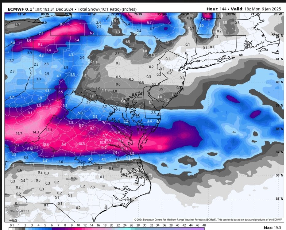
-
Mid to Long Range Discussion ~ 2024
BornAgain13 replied to buckeyefan1's topic in Southeastern States
I think would take the High being in a better position! Lots of cold air! -
Mid to Long Range Discussion ~ 2024
BornAgain13 replied to buckeyefan1's topic in Southeastern States
18z GFS definitely a good run for my neck of the woods... Northern NC, Southern VA get smoked this run... -
Mid to Long Range Discussion ~ 2024
BornAgain13 replied to buckeyefan1's topic in Southeastern States
I know the Euro still wasn't what we all wanted, but that shift south was noticeable... Let's see what 18z says... -
Mid to Long Range Discussion ~ 2024
BornAgain13 replied to buckeyefan1's topic in Southeastern States
12z GEFS is improved from 6z in the northern parts of this forum. -
Mid to Long Range Discussion ~ 2024
BornAgain13 replied to buckeyefan1's topic in Southeastern States
12z CMC is definitely an ICE storm for NC and southern VA -
Mid to Long Range Discussion ~ 2024
BornAgain13 replied to buckeyefan1's topic in Southeastern States
Yeah unfortunately the GFS is on its own right now. Would love for it to be accurate but it hasn't been scoring well lately ... -
Mid to Long Range Discussion ~ 2024
BornAgain13 replied to buckeyefan1's topic in Southeastern States
Would love for the GFS To be right but not gonna get to excited unless Euro gets on board. Need that HP on the Euro to press down like the Gfs -
Mid to Long Range Discussion ~ 2024
BornAgain13 replied to buckeyefan1's topic in Southeastern States
12z GFS with a Big Snow for most of NC and into VA!! -
Mid to Long Range Discussion ~ 2024
BornAgain13 replied to buckeyefan1's topic in Southeastern States
12z runs starting to come... First up , 12z ICON with a cold rain for most. Significant Snow in Central and Northern VA. -
Mid to Long Range Discussion ~ 2024
BornAgain13 replied to buckeyefan1's topic in Southeastern States
Are you and @wncsnow related? I'm just picking -
Mid to Long Range Discussion ~ 2024
BornAgain13 replied to buckeyefan1's topic in Southeastern States
6z is a beaut... Definitely wish we had the euro on our side and not the GFS Though ... But still plenty of time to track. -
Mid to Long Range Discussion ~ 2024
BornAgain13 replied to buckeyefan1's topic in Southeastern States
CMC is a Ice Storm for N NC and VA -
Mid to Long Range Discussion ~ 2024
BornAgain13 replied to buckeyefan1's topic in Southeastern States
Gives me about 3" Kuchera. I'll take it. Although it was wonky. It was snowing and in the 20s. -
Mid to Long Range Discussion ~ 2024
BornAgain13 replied to buckeyefan1's topic in Southeastern States
I think it got sheared out or something -
Mid to Long Range Discussion ~ 2024
BornAgain13 replied to buckeyefan1's topic in Southeastern States
What in the world was that? Lol -
Mid to Long Range Discussion ~ 2024
BornAgain13 replied to buckeyefan1's topic in Southeastern States
Stronger HP to the North so far... -
Mid to Long Range Discussion ~ 2024
BornAgain13 replied to buckeyefan1's topic in Southeastern States
If anyone is looking for food news, the 18z GEFS is improved from 12z, fairly significantly... Especially for some in NC and VA -
Mid to Long Range Discussion ~ 2024
BornAgain13 replied to buckeyefan1's topic in Southeastern States
A lot of doom and gloom posts on here today. The signal is still there folks. The ensembles still look decent to. It won't take much to windshield wiper this back in everyone's favor.


