

BornAgain13
-
Posts
2,879 -
Joined
-
Last visited
Content Type
Profiles
Blogs
Forums
American Weather
Media Demo
Store
Gallery
Posts posted by BornAgain13
-
-
To bad its the long range NAM. It actually looks pretty good. The vort is not flat or strung out, almost neutral tilt... who knows where it would have went...
-
 2
2
-
-
Just now, olafminesaw said:
Columbia to Charlotte to Fayetville could be in for a big time storm for their standards
That would actually be funny to me cause Brad Panovich this morning pretty much Said it just isn't much there.
-
 1
1
-
-
6 minutes ago, buckeyefan1 said:
What's crazy is it's not some large adjustment to get the job done. At hr 90 it's just enough to give someone a surprise

If it would tilt negatively a little more, that would probably be all the adjustment you need...
-
GFS is on its own right now unfortunately. Unless things shift today or tomorrow, the Euro will have had the right idea...
-
It does seem like this winter that we usually have 1 or 2 models show a good hit between 5-7 days out. And then it goes poof... I guess it's to progressive of a pattern and the systems just stay to far south and have no chance to kreep northward.
-
I guess the GFS isn't the King after all.... the Euro has been showing a suppressed look the whole time....
-
1
-
-
Most guidance shows a flat and suppressed system. Even the GFS is trending that way..
-
Saw this on mid Atlantic thread.... 18z Euro control for Sunday
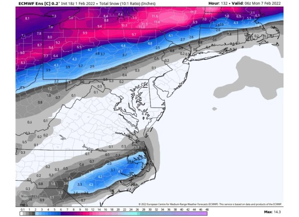
Sent from my SM-N981U using Tapatalk -
5 minutes ago, Sandstorm94 said:
What a beautiful bowling ball

Sent from my SM-S115DL using Tapatalk
Can someone elaborate on this? Would this turn out good for a Winter Storm with this look?
-
By my untrained eye, the 18z Euro was setting good for Sunday. Someone else with more experience can elaborate.
-
Would love for the GFS to be right but I really hate the Euro isn't on board.
-
2
-
-
13 minutes ago, jlewis1111 said:
for which day night?
Sunday/Sunday night
-
1
-
-
6z GFS still has a major ice storm this morning... 0z euro jumped on board with a little more snow/ice. We will see how this continues to go. UK still has it. The cmc is still not there...
-
1
-
-
Guessing the EPS wasn't hitting on much?
-
Just now, PantherJustin said:
I don’t work for WPC… but imo I’d draw something like this… as a general “idea” no amounts obviously but for that little track thing they do 5-7 days out … roast me if you want

I agree with that, except I would draw the ice line a little further east...
-
What's encouraging, and the take away from 12z, is most guidance is showing something wintry around Sunday/Monday time frame... 12z CMC is more suppressed but we will see...
-
1
-
-
12 Euro FREEZING RAINEuro doesn't have much.
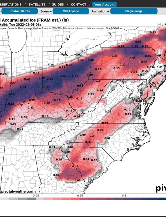
Sent from my SM-N981U using Tapatalk
-
12z EURO has a similar set up as GFS, just not near the moisture and it's not amped. BUT... their is a signal there
-
I put a lot more stock in the GFS since the upgrade.... whether it shows winter weather or not... its clearly better than it used to be...
-
2
-
-
23 minutes ago, wncsnow said:
The long range overall is looking warmer and warmer
And just like this time, as it gets closer, it probably won't be as warm as modeled.
-
Yep. 6z gfs is a Major ice storm next Sunday for the piedmont.
-
2
-
-
Taken verbatim, the 0z ICON is a Major Winter Storm for the Carolinas on up into Virginia. Snow to the north and ICE to the south.
-
Anybody who has the precip type maps or totals for the icon can show that better.
-
0z ICON with another run of a Major Winter Storm next Sunday for the Carolinas and Virginia. Snow on the northern fringe changing to ICE
-
1
-


Mid to Long Range Discussion ~ 2022
in Southeastern States
Posted
The NAM was on its way to being a decent storm somewhere... ending the run on a neutral tilt plowing east...