

Frog Town
-
Posts
968 -
Joined
-
Last visited
Content Type
Profiles
Blogs
Forums
American Weather
Media Demo
Store
Gallery
Everything posted by Frog Town
-
It'll be back to it's Sunday solutions by 12Z Wednesday.
-
You are awesome for sharing your craft with us in a way that is priceless to wienies like us. Thank you!
-
We are all suckers!
-
Bribing the weather Gods I see..
-
I never do this but.....That's me in the green.
-

Winter 2022/23 Short/Medium Range Discussion
Frog Town replied to Chicago Storm's topic in Lakes/Ohio Valley
Pretty nice looking but it's an outlier at this point despite the nice ensemble look. -
Winter 2022/23 Medium/Long Range Discussion
Frog Town replied to Chicago Storm's topic in Lakes/Ohio Valley
I hope it's wrong as this is about the time i'm looking forward to things warming up. Darn Murph! -
I work in Lenawee County Michigan and everything is shut down.
-
Nice lightning and thunder during our ice storm now. What's next??
-
Sitting at 32.4 with a dewpoint of 29 here in a NW suburb of Toledo. Lots of ice on trees but none on the roads. Heavy Freezing Rain currently.
-
Just give me a neutral ENSO for the love of God!
-
Nice spacing with that GIF...Nice and slow for this old guy.
-
Weed is legal in Michigan...
-
Antecedent conditions do not favor ice like that..at least in the Chicago to Detroit corridor.
-
I think we need to get this current system out of the way to first..
-
Winter 2022/23 Medium/Long Range Discussion
Frog Town replied to Chicago Storm's topic in Lakes/Ohio Valley
Classic "Bowling Ball" storm. Haven't seen one of those in a long time! -
Winter 2022/23 Medium/Long Range Discussion
Frog Town replied to Chicago Storm's topic in Lakes/Ohio Valley
It's gonna change, and when it does, it's gonna catch all of us off guard....even A-L-E-K! -
Is it just me, or does there seem to be some major changes going on for next week. GFS and Euro both starting to show much colder temps after the 20th now. Even chances of snow! Could...this...be....what...we've .....been waiting for??
-
It's been hear since January 3rd...LOL.
-
Look at it this way...if we didn't have winters like this, then we wouldn't enjoy the normal winters.
-
If it hits 70+ in mid february and stays warm the rest of february, then it will feel like Feb '98
-
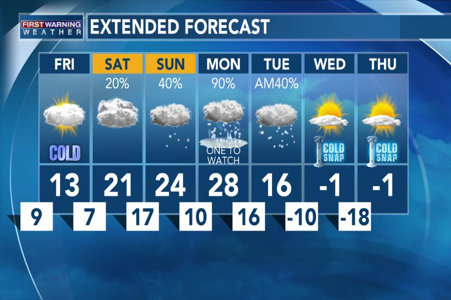
That's example what happened in our sub during the January 2019 outbreak. The Sunday following the Thursday in this graphic pushed 50+ degrees...
-
Same..
-
The Summer in between, Summer of 2014, was like a Fall season. Your memory serves you correctly. Cold than normal Lakes perhaps..
-
Is it just me or do the short term Hi-Res models seem to be picking up on this baroclinic zone sticking around a bit longer with a weak wave hitting parts of the area?? I know suppression is upon us but if it could just stay a little closer some of us could cash in.


