dj3
-
Posts
619 -
Joined
-
Last visited
Content Type
Profiles
Blogs
Forums
American Weather
Media Demo
Store
Gallery
Everything posted by dj3
-

Western PA/Pittsburgh Winter 2021/22 Discussion
dj3 replied to meatwad's topic in Upstate New York/Pennsylvania
Starting to see some convergence. 8-12 starting to look more and more solid. -
Western PA/Pittsburgh Winter 2021/22 Discussion
dj3 replied to meatwad's topic in Upstate New York/Pennsylvania
Nice bullseye over your house -
Western PA/Pittsburgh Winter 2021/22 Discussion
dj3 replied to meatwad's topic in Upstate New York/Pennsylvania
Watching the weather channel now. I miss how the extended forecast used to have that BIG snowflake when it was going to snow. The extended now just says pm snow showers lol. That’s when you new a big storm was coming
-
Western PA/Pittsburgh Winter 2021/22 Discussion
dj3 replied to meatwad's topic in Upstate New York/Pennsylvania
Yea almost identical to rgem -
Western PA/Pittsburgh Winter 2021/22 Discussion
dj3 replied to meatwad's topic in Upstate New York/Pennsylvania
I feel like the rgem owes us one -
Western PA/Pittsburgh Winter 2021/22 Discussion
dj3 replied to meatwad's topic in Upstate New York/Pennsylvania
Looked way warmer despite not much of a shift in track. Let’s see what Reginald has to say -
Western PA/Pittsburgh Winter 2021/22 Discussion
dj3 replied to meatwad's topic in Upstate New York/Pennsylvania
Precip totals are really low west of the low everywhere on that run compared to other models -
Western PA/Pittsburgh Winter 2021/22 Discussion
dj3 replied to meatwad's topic in Upstate New York/Pennsylvania
Yea I agree. Like I said before it locks into that from this far out tip your cap. -
Western PA/Pittsburgh Winter 2021/22 Discussion
dj3 replied to meatwad's topic in Upstate New York/Pennsylvania
Yep dry slotted again with perfect track lol. -
Western PA/Pittsburgh Winter 2021/22 Discussion
dj3 replied to meatwad's topic in Upstate New York/Pennsylvania
Rgem would be a huge hit if it went out further I think. I like gfs and Canadian precip swath better than the spotty crap the Nam threw out there. This is a pretty dynamic system you’d think someone is getting really good rates -
Western PA/Pittsburgh Winter 2021/22 Discussion
dj3 replied to meatwad's topic in Upstate New York/Pennsylvania
That other low pressure reflection meandering in central west virginia probably doesn't help with the dryslot. I'll write it off to bad luck if we get the models spot on with that dry slot from 100 hours out. -
Western PA/Pittsburgh Winter 2021/22 Discussion
dj3 replied to meatwad's topic in Upstate New York/Pennsylvania
The low track seems perfect. Is this more just subsidence between the really good banding just west of the occluded low pressure and the deform band much further west? I would expect a dry slot if this was tracking right over head but it isn't. -
Western PA/Pittsburgh Winter 2021/22 Discussion
dj3 replied to meatwad's topic in Upstate New York/Pennsylvania
Yep. Was worried about a shift east but looks really similar to 6z -
Western PA/Pittsburgh Winter 2021/22 Discussion
dj3 replied to meatwad's topic in Upstate New York/Pennsylvania
I'll be concerned if the GFS OP starts to follow the ensembles. It did the best with first picking up on the trend for a storm Monday and Tuesday. -
Western PA/Pittsburgh Winter 2021/22 Discussion
dj3 replied to meatwad's topic in Upstate New York/Pennsylvania
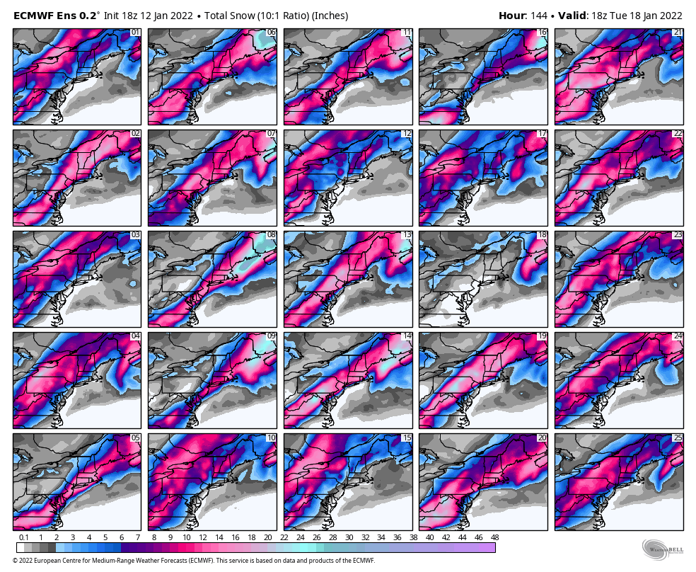
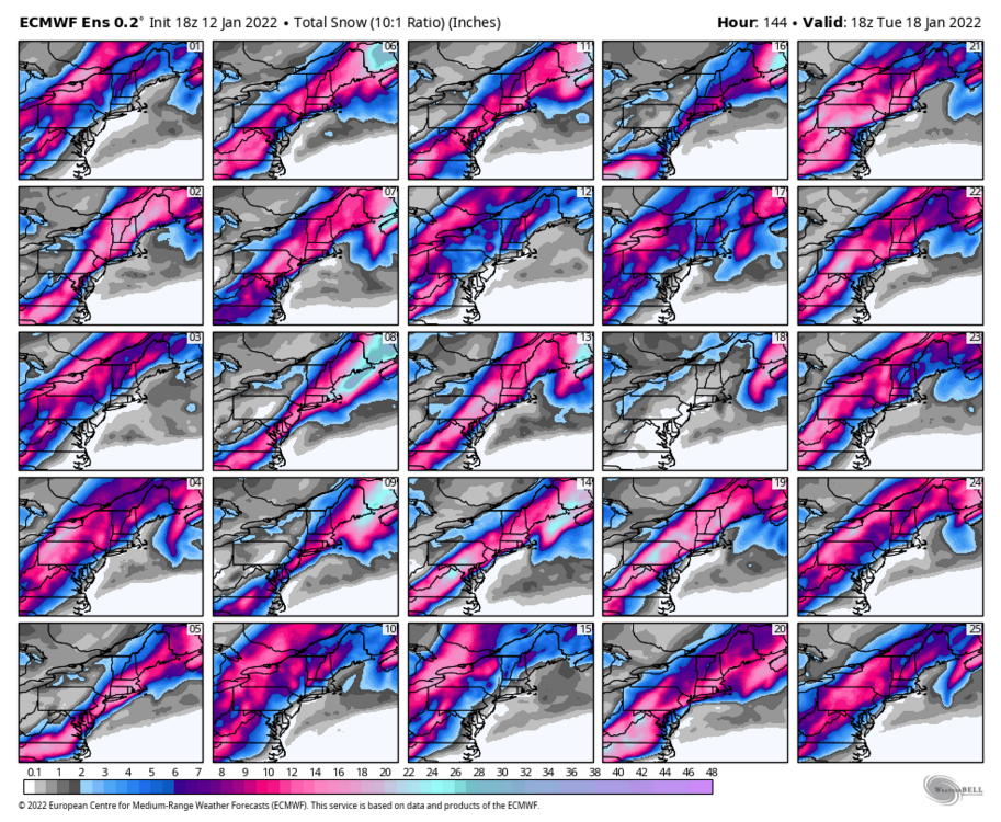
A lot of good hits in there. That’s the best eps run I’ve seen thus far with the least number of total whiffs. Consensus building I would say for some type of impact. -
Western PA/Pittsburgh Winter 2021/22 Discussion
dj3 replied to meatwad's topic in Upstate New York/Pennsylvania
Hopefully that is ok to copy and paste those. Apologize if not. -
Western PA/Pittsburgh Winter 2021/22 Discussion
dj3 replied to meatwad's topic in Upstate New York/Pennsylvania
-
Western PA/Pittsburgh Winter 2021/22 Discussion
dj3 replied to meatwad's topic in Upstate New York/Pennsylvania
Just going by snowfall maps from upstate ny thread.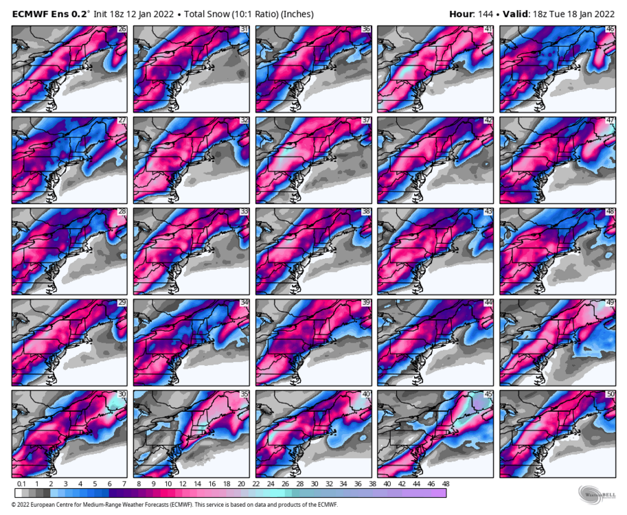
-
Western PA/Pittsburgh Winter 2021/22 Discussion
dj3 replied to meatwad's topic in Upstate New York/Pennsylvania
I count about 15-20 closes misses or whiffs on individual members. Almost all look to be East. -
Western PA/Pittsburgh Winter 2021/22 Discussion
dj3 replied to meatwad's topic in Upstate New York/Pennsylvania
Mean snowfall increased a bit from 12z. -
Western PA/Pittsburgh Winter 2021/22 Discussion
dj3 replied to meatwad's topic in Upstate New York/Pennsylvania
I think the last few cycles that ocean storm has trended closer to the coast and slower to depart but it had been offset by the northern steam energy phasing in being stronger and forcing this directly north like @RitualOfTheTroutmentioned. I’m guessing we will need that to continue to be as potent or the ocean storm trends will shift this east. -
Western PA/Pittsburgh Winter 2021/22 Discussion
dj3 replied to meatwad's topic in Upstate New York/Pennsylvania
From what I’ve read we want that to move out quicker or be further East so that ridging can build along the coast and not allow this to escape out to sea/force it more inland toward the apps or coastal plain. -
Western PA/Pittsburgh Winter 2021/22 Discussion
dj3 replied to meatwad's topic in Upstate New York/Pennsylvania
Yea a bunch of scrapes misses to the East on there. Still half or so with a decent to big hit -
Western PA/Pittsburgh Winter 2021/22 Discussion
dj3 replied to meatwad's topic in Upstate New York/Pennsylvania
Where at? Would love to be in the Laurels for this. -
Western PA/Pittsburgh Winter 2021/22 Discussion
dj3 replied to meatwad's topic in Upstate New York/Pennsylvania
EPS mean bumped up a decent amount like the GEFS did. 6 inch line splitting Allegheny county. I agree with both of you above, I am still slightly more concerned that the low does not get pulled directly north and takes more of an out to sea trajectory. Until I see some of the misses on the ensembles start to become slop/west misses I still think we have some wiggle room there.