Normandy Ho
-
Posts
2,639 -
Joined
-
Last visited
Content Type
Profiles
Blogs
Forums
American Weather
Media Demo
Store
Gallery
Everything posted by Normandy Ho
-
Yea I was going to say, the consolidation looks to be happening just east of grand cayman. Would a stronger storm initially be influenced to hook more hard right in this setup?
-
A lot of the vorticity seems south of Cuba this morning. Not sure it affects track too much but it may have more time over water if it consolidates south of Cuba while moving WNW
-
I think the takeaway is as the storm first approaches the coast conditions begin to get very favorable, and continue to be so as the storm stalls. As @Windspeedsaid land interaction is key. Upwelling also might become a factor if it gets very intense before the stall
-
Yessir! First call is a stall somewhere west of Florida. Complicated setup with blocking madness
-
2024 Atlantic Hurricane Season
Normandy Ho replied to Stormchaserchuck1's topic in Tropical Headquarters
Thanks for the opportunity brother but I’m not disciplined enough to keep the titles updated lol. It’ll stay as a TD in the title thread throughout its life -
2024 Atlantic Hurricane Season
Normandy Ho replied to Stormchaserchuck1's topic in Tropical Headquarters
Very interesting scenario being pointed by the models. Lots of rain coming for someone as the storm gets stuck and trapped. The euro even has it moving SSE across Florida and then up the east coast. Might be time for a separate thread? -
2024 Atlantic Hurricane Season
Normandy Ho replied to Stormchaserchuck1's topic in Tropical Headquarters
Still some uncertainty as there is disagreement between the big dogs. GFS seems to be somewhat caving to the euro as it’s abandoned the idea of sending this west after the stall. Euro still thinks this is an east coast brusher. -
2024 Atlantic Hurricane Season
Normandy Ho replied to Stormchaserchuck1's topic in Tropical Headquarters
Not seeing the juice with this one. Interesting how the euro and GFS seem to be split in two camps with respect to ultimate track -
2024 Atlantic Hurricane Season
Normandy Ho replied to Stormchaserchuck1's topic in Tropical Headquarters
I think compared to this board the level of expertise and knowledgeable posters is just severely lacking over there. Additionally the moderators are absolutely childish and squash any and every inkling of disagreement. They treat posters like they are children which is ….. yea not for me. I was a longtime member there and when I found this place I never posted there again -
2024 Atlantic Hurricane Season
Normandy Ho replied to Stormchaserchuck1's topic in Tropical Headquarters
You are doing the good work sir of sifting through the garbage to find the good stuff for us over here. You should get chris / wxman57 to come over here. That board is a wasteland What’s weird about this disturbance is…..where is it? I looked at satellite and there’s just jack shit out there. Gonna be interesting to see this unfold because the models are clearly latching onto something. Seems like a pattern for some kind of recurve near the east coast? -
2024 Atlantic Hurricane Season
Normandy Ho replied to Stormchaserchuck1's topic in Tropical Headquarters
I do think overall numbers will underperform. I think I called for 26 total but I’m bringing that down a bit. I still think we get tons and tons of majors though -
Gotta love the mini hurricane looking tornadic tropical supercells

-
Tropical Cyclone Tornado Outbreak: Beryl
Normandy Ho replied to Quincy's topic in Central/Western States

-
Tropical Cyclone Tornado Outbreak: Beryl
Normandy Ho replied to Quincy's topic in Central/Western States
Yep beryl is wreaking havoc on the south today. Some of these hooks are scary -
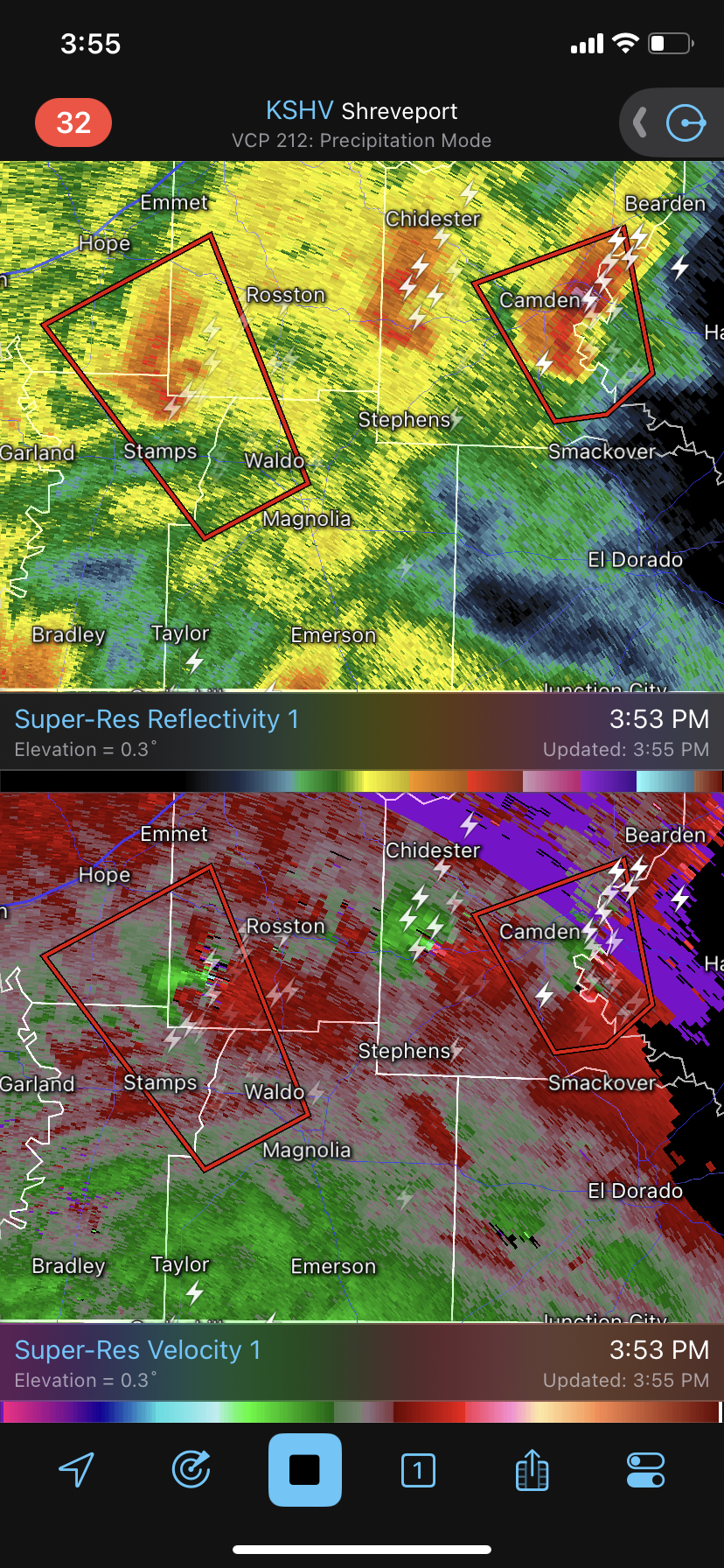
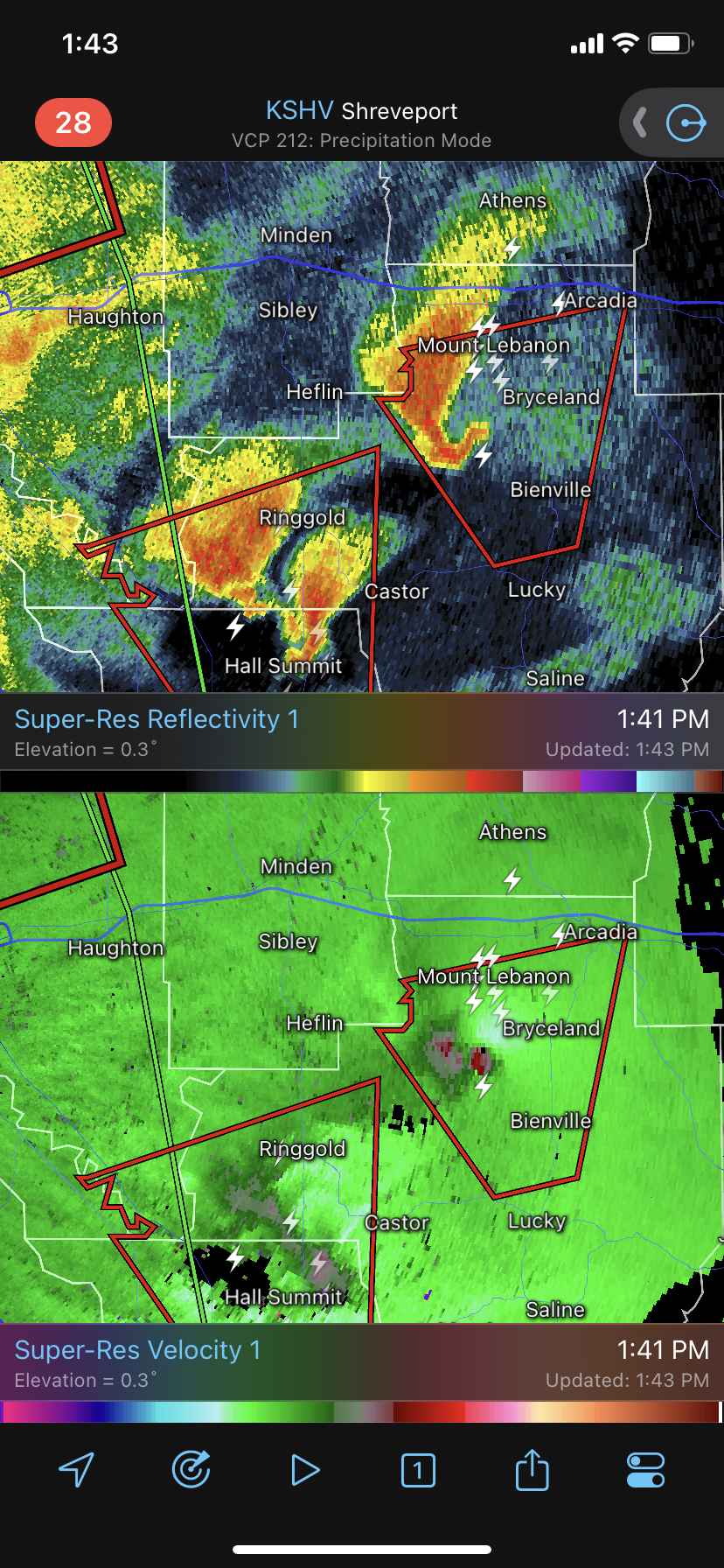
Tornado outbreak occurring in N LA and Texas.
-
I think the upper dynamics are so incredible that’s it’s basically turning this system into an inland hurricane. Family in Houston still can’t go outside because the winds are so strong
-
HUGE inland wind event still ongoing. Family still texting me I. Houston asking when the winds will stop. Just a monster of a storm
-
Family is ok but they all agree this is the scariest hurricane they have ever experienced. Fortunate does not even begin to describe how the upper Texas coast should feel. The way this thing was deepening at landfall even six more hours over water and we get monster hurricane winds well inland. Wild storm and good riddance. Enjoy your retirement.
-
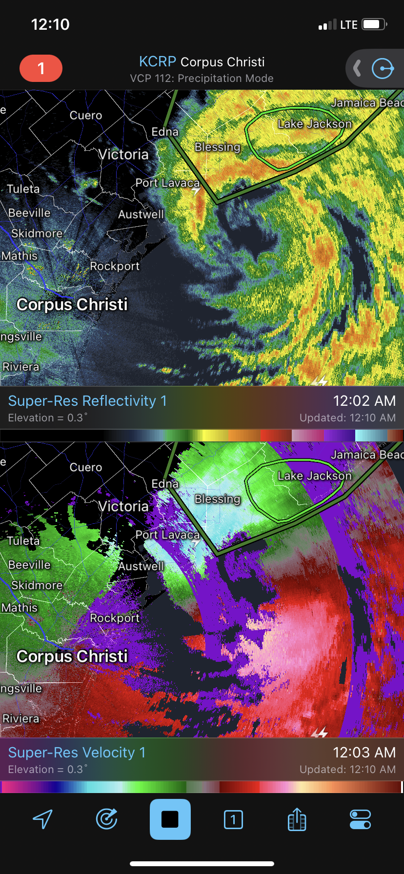
The radar velocity data from Corpus Christi is very telling. The core of this hurricane is gigantic. There are portions of the southern eyewall well offshore with similar velocities as those near matagorda right now. Gonna be a long long night and morning.

-
Center now has 3 mesos rotating around it. Intensifying VERY fast. Frictional convergence might make things worse. This will be as bad as the derecho last month for Houston (and likely worse). Radar velocities steadily rising. Gonna be rough for my home city. Could have been worse though.
-
yep starting to crank just a little bit. family down near lake jackson says its getting windy.
-
http://tropic.ssec.wisc.edu/real-time/dlmmain.php?&basin=atlantic&sat=wg8&prod=dlm3&zoom=&time= The stronger this storm gets the more its going to be pushed NNE. the slowdown and due north center fix is interesting and might indicate this might be happening. Seeing zero gains longitudinally now and still due south of houston. gotta keep watching. Additionally, looks like we got a big meso on the south side again. lets see what happens as it rotates around.
-
Also NNE if previous fix. Have to watch closely over the next few hours. This might be feeling the trough more than expected (which is great for Houston if true)
-
That and an east slide. One thing I’m watching…….the storm is due south of Houston and intensifying. The trough is digging and will start to influence beryl. I’m not seeing this getting far enough west to matagorda from its current position
-
@40/70 Benchmark I think you hit your 95 mph call. there are signs that Beryl is starting to deepen. Velocity on radar is increasing, big blow up / meso on the south side is rotating around, and potential new hot towers on the north side are firing. I do think its too late for a major but 95 mph might still be possible.