

Normandy Ho
-
Posts
2,641 -
Joined
-
Last visited
Content Type
Profiles
Blogs
Forums
American Weather
Media Demo
Store
Gallery
Everything posted by Normandy Ho
-
oh man when people wake up tomorrow…..yikes. The amount of strong mesovorts on IR is quite stunning
-
12 mb drop between passes?!?
-
Considering how this thing looks on radar and satellite I think they find big winds in the NE quad
-
Agree on ETA last year that was truly hilarious shit. Looking forward to maybe some of that tonight
-
The absolute worst case is a westward approach where the north eyewall passes over Lake P. The approach ida is taking is the second worst case. Strong NE winds will back water up into the lake, and strong south winds bring surge from the south.
-
New Orleans is in trouble from a surge perspective no matter where the storm hits because of the angle of approach and general proximity of the core. The only question is do they get the Cat 3 or greater winds.
-
Storm is about to go to work now. Wouldn’t be shocked if it was a major by noon
-
That’s a terrible rant and take. “Storms always will happen so we shouldn’t try and be better with our carbon footprint”. It should have been deleted and should be removed again
-
Stick to the banter thread and you’ll be safe
-
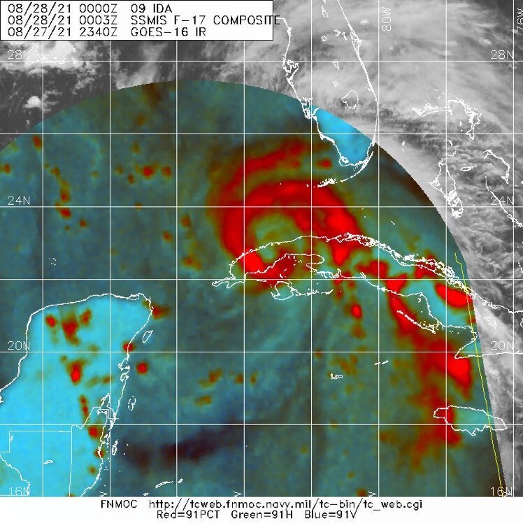
This microwave image is suggestive of a much larger core forming. Will be interested to see what recon finds
-
agreed nobody should mention that glorified Nor’easter when we speak of real cyclones
-
This hot tower going up gotta be one of the wildest I’ve seen
-
We should allow those types of discussions. The radar attenuation argument was one of the funniest I’ve read
-
https://www.barbadosweather.org/Composite/kidbuuComposite_Lionel_displayer2.php?Product=Reflectivity&Sector=EC_Bar&Composite=Sabre&ANISP=50&MAPP=1&PlanetOfTheApes=58710 center is very well defined On Barbados radar. Seems to be also racing westward
-
Nailed it Windspeed. It looks like a squall line with the wake low tagging behind it. The low level flow to the south is also beginning to be tugged north as well. Seems to be developing nicely but slowly
-
Eta is pounding Nicaragua. I was sure it would be inland by now
-
Big winds now starting to come out to play
-
This is one of the funniest weather moments of my life. Glad I could share it with yall
-
LMAO
-
It's rotating so fast it looks like the damn lighting strikes are being thrown around the eyewall.
-
Windspeed that shit is not safe for work....got me sweating looking at it
-
You have a whole bunch of them at the NHC. I kid I kid
-
Look man I hear you....but every single storm I've seen that looks this vicious has been either sub 900 or 180+ mph. We shall see soon
-
Revising my call. 883 mbs. 160 knots. New record holder. Looks to nasty on satellite to ignore.
-
That's what I wanted to say but I'm too chickenshit


