Normandy Ho
-
Posts
3,295 -
Joined
-
Last visited
Content Type
Profiles
Blogs
Forums
American Weather
Media Demo
Store
Gallery
Everything posted by Normandy Ho
-
Yea whiffed on this one. on to the next!
-
Best it has ever looked. very strong mid to low level circulation now it would seem.
-
Indeed most of the vorticity is still above the surface. Recon was flying very low investigating this.
-
This one is screaming over performer to me. Lets see what recon finds.
-
Me thinks we get Danielle out of this. its well organized enough right now and has a lot of time over water
-
The vort max further norther is the one I would watch. Seems to be more dominant
-
2022 Atlantic Hurricane season
Normandy Ho replied to StormchaserChuck!'s topic in Tropical Headquarters
Not all all crazy for watching this homebrew wave. Its further north than modeled and already has great vorticity. -
2022 Atlantic Hurricane season
Normandy Ho replied to StormchaserChuck!'s topic in Tropical Headquarters
What's the point of looking at models then? Why are we even here? -
2022 Atlantic Hurricane season
Normandy Ho replied to StormchaserChuck!'s topic in Tropical Headquarters
See you in November iduB! The bell has been rung. GFS nails the Gulf Coast with the seasons first major. -
2022 Atlantic Hurricane season
Normandy Ho replied to StormchaserChuck!'s topic in Tropical Headquarters
Might have another homebrew situation occurring of the Great Bend of Florida. This one would have more water in front of it -
The vort max ESE of Brownsville might be the one to watch
-
Starting to look very good on radar. Odds are up this gets a name I think
-
2022 Atlantic Hurricane season
Normandy Ho replied to StormchaserChuck!'s topic in Tropical Headquarters
if the GFS is to be believed, August will still pump out at least 4 NS. The MDR is absolutely cooked though, or it will have an absurdly late start. -
2022 Atlantic Hurricane season
Normandy Ho replied to StormchaserChuck!'s topic in Tropical Headquarters
The bad news.....98L is vanishing. The good news....look off the SE coast. -
2022 Atlantic Hurricane season
Normandy Ho replied to StormchaserChuck!'s topic in Tropical Headquarters
The only negative factor I see (and it seems like its a general issue with systems this year)....we have two areas of of competing vorticity.. I see one due south of Louisiana and another east of Brownsville -
2022 Atlantic Hurricane season
Normandy Ho replied to StormchaserChuck!'s topic in Tropical Headquarters
This GOM system i think might be slept on. Looking at the cloud fields over Texas and Louisiana, there seems to be a very large developing low SSW of New Orleans. -
2022 Atlantic Hurricane season
Normandy Ho replied to StormchaserChuck!'s topic in Tropical Headquarters
Eating my popcorn watching this unfold. Idub looking strong today! -
2022 Atlantic Hurricane season
Normandy Ho replied to StormchaserChuck!'s topic in Tropical Headquarters
The models showing so little Cape Verde activity is interesting (and spooky, because perhaps this will be a west based peak season). Will have to watch closely and see if this comes to fruition over the rest of the month. -
2022 Atlantic Hurricane season
Normandy Ho replied to StormchaserChuck!'s topic in Tropical Headquarters
I easily see a path to 18 / 8 / 5. September alone can produce nearly half of these numbers when things get going. Additionally we have no idea what November is going to look like. -
2022 Atlantic Hurricane season
Normandy Ho replied to StormchaserChuck!'s topic in Tropical Headquarters
Unless they form further west. Most MDR storms end up fish regardless. It does look like SNE is gonna miss out this year though -
2022 Atlantic Hurricane season
Normandy Ho replied to StormchaserChuck!'s topic in Tropical Headquarters
@ ldub23 Can we make a deal? If the season ends above average can you never post in this topic again? If it ends below average, I never post in this topic again. I like your enthusiasm but I think we need some stakes on this take (WWF career match style). -
That seems like a pretty significant nighttime tornado event...hopefully it under produces.
-
Surprised there isn't more activity on this event currently on-going. hopefully everyone ins its path is ready
-
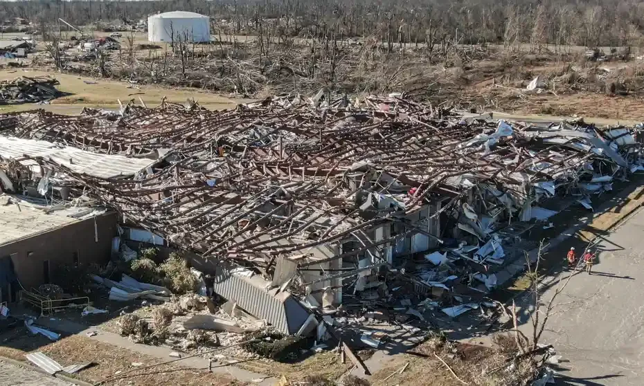
I disagree. Warehouses like this actually do the opposite as what you are stating. The lack of interior bearing walls, methods of roofing attachment, and methods of exterior wall attachment of warehouse buildings means that a violent tornado is likely to remove the building skin and roof within second. It would be akin to peeling off a sheet of paper, leaving the structural frame completely exposed. Once the structural system is completely exposed, there is no "wind catching" whatsoever. The deformation you are seeing is the winds deforming the structural system with whatever PSF is required to deform the steel. In general this is 35,000 PSI of force, which is produced by 306 MPH winds. Lets clarify removal of anchor plates as well. Anchor plates are the means by which steel columns transfer load to the foundation structure. Steel beams are connected to said columns using moment connections or fixed bolted connections. In this case because seismic is not a concern, fixed bolted connections are likely being used. If a steel frame, which acts as one rigid body, is being deformed to the point of collapse.....you can bet an EF-5 is the culprit. Winds below 200 mph are simply not enough to mangle a low-story, wide base steel structure that has beams up to 2'-0" deep. Focus on the structural system, not the overall building damage. Wind catching is more of what you are seeing here: Where a structure is so tall that the wind exerts large amount of force on the upper half of a structure that the mid point deforms. In this case, it absolutely does NOT take 35,000 PSI to deform the steel because there is additional force being generated by the top heavy structure moving laterally. https://www.columbian.com/news/2017/feb/20/storms-damage-san-antonio-area/ EDIT: Here is a great video that illustrates how insane it is that a steel structure can be deformed to the point of collapse by winds. This is our famous gas station video of hurricane charley. it is widely assumed that winds in this video reached somewhere between 140 - 150 mph sustained. That is well below the EF-5 threshold obviously, and notice what happens to the steel frame: Nothing. The same kind of process happens when a tornado hits a warehouse building. The skin is shredded leaving the structure exposed. Whether that structure gets deformed further depends on the wind / PSF generated. Here it was below the threshold to bend steel. In Mayfield it clearly was not.
-
if you want photographic evidence of EF5 damage, look no further than the candle factory. We have an entire steel frame that has been bent and deformed to the point that the steel Columns holding the steel beams collapsed. steel deformation / bending occurs after 35,000 PSI (or 247 PSF). It takes 306 mph winds to produce 247 PSF. And yet we are looking at slabbed homes and determining the structures aren’t well built? As I said before, these folks have no clue what they are looking at and it really is unfortunate.