

Normandy Ho
-
Posts
3,295 -
Joined
-
Last visited
Content Type
Profiles
Blogs
Forums
American Weather
Media Demo
Store
Gallery
Everything posted by Normandy Ho
-
Looking at the morning model suites, I am starting to believe more in an eastern solution where the cyclone recurves across the FL peninsula. The GFS is spuriously developing vortices that keep this unorganized until the NW Caribbean. Morning visible images and ASCAT confirm a tight closed circulation, and I see no reason this doesn't stay consolidated. This spurious vorticity causes it to get much further west than it would if it were an organized cyclone. I also think the GFS is underselling the interaction between the first trough and the cyclone. A trough that strong isn't going to just tug this north and leave it, especially if the storm is already a hurricane upon interaction with the trough.
-
GFS is insisting the first trough has little effect on our cyclone. Not sure I buy it, buts lets see how it plays out
-
Synoptically it makes sense. The trough is very transient and fast moving and the storm is very far south. Additionally there is a monster ridge building in behind the first trough.
-
As we move closer, there are two potential solutions developing: - Solution 1 misses the connection on the first trough, causing the storm to instead slowly move NNW until eventual landfall on the N GOM cost (still likely Florida Panhandle, but some potential of a Alabama or MS landfall is on the table) - Solution 2 does not miss the connection of the first trough, and instead the storm is yanked NE across SE FL. What's more concerning than even that, the trough does not take the storm out to sea and instead leaves it heading due North into a building ridge above. Even if it misses S FL to the east, it just means an East coast strike further up the coast. In short: US is in SERIOUS trouble with this one.
-
Euro is getting veeeeeeery close to Halifax with a 927 mb storm.
-
The Euro shows the potential for an S FL / East Coast Strike. The bend north after the recurve is a bit unsettling....
-
2022 Atlantic hurricane season whining/banter
Normandy Ho replied to GaWx's topic in Tropical Headquarters
They have a pretty great handle a few days (3 or less) out. But to expect them to predict a tropical cyclone will form five days out? Thats a big ask IMO. Would like a promets thoughts though. -
2022 Atlantic hurricane season whining/banter
Normandy Ho replied to GaWx's topic in Tropical Headquarters
Why would models be any good a predicting medium to long range cyclogenesis with accuracy? That's an extremely big ask, especially for something so small in scale like TCG. The best approach (which many DO NOT take) is to wait and see before making grand nonsensical statements calling a season dead. Not calling you out cptcatz at all, just saying a statement in general. Oh and I'll also mention Idub should get the screename change to iWeenie. -
Looking forward to the eyecandy over the next two days. Fiona is about to get WILD
-
While the details are still to be worked out, in my mind the big synoptic picture is somewhat clear. Our Invest will miss the weakness carrying Fiona north and will slide west into the Caribbean under a transient ridge to the north. Once it gets past Hispaniola it will begin to move WNW in response to a weakness developing ahead near the Yucatan. Once near or past Jamaica it begins its recurve into the Eastern GOM. Gonna be some long nights ahead.
-
With the size of the system that is the worst case scenario for Tampa. The eyewall would be just offshore, but the surge would still pound the bay. Also these recurving systems tend to slide east (at least from what ive seen tracking the last 20 years).
-
Going to be one of the wildest ET transitions to witness. Hopefully it bombs during the daytime
-
One of the most threatening storms from a model perspective I can remember in the last five or ten years. Models forecasting a large and extremely intense recurving hurricane that would bring monster winds hundreds of miles inland.
-
One would expect a turn NW soon. But it is very peculiar that its still heading west while already being south and west of the models. mountain interaction could become a factor if the turn is delayed.
-
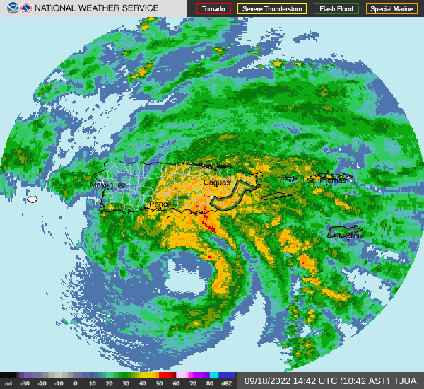
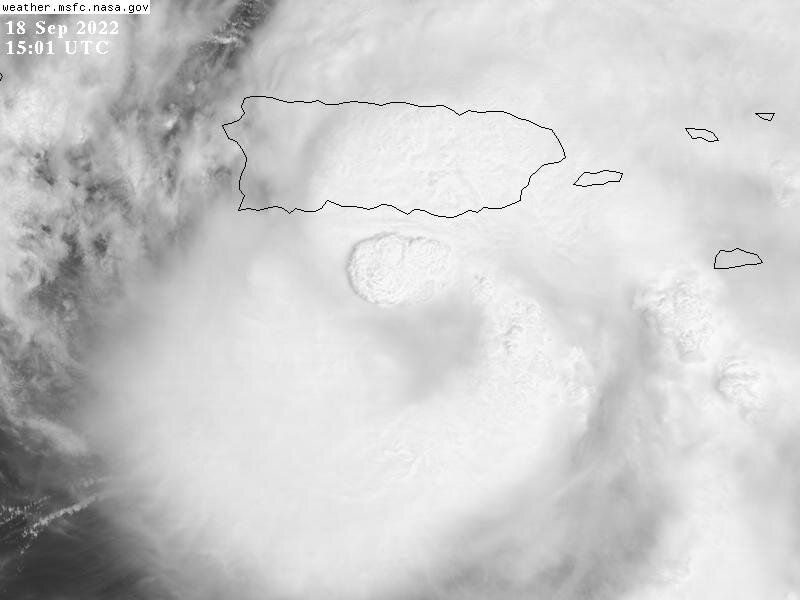
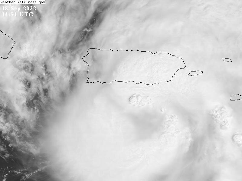
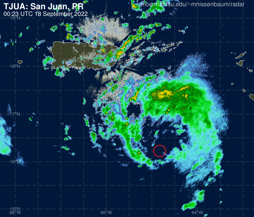
Extreme and devastating rain event on-going in Puerto Rico unfortunately. Radar showing a WSW dive with the eye motion...perhaps the start of the turn more WNW to NW.
-
The turnaround this thing has done from entering the Caribbean as a naked swirl is astounding. I never thought it would get its act together like this.
-
Fiona putting 103 MPH wind gusts on Ponce right now.
-
Big ups for that website! Radar is showing a monster sized eyewall developing
-
Hopefully somebody is saving an extended radar loop. Its very rare you get to see a rapidly intensifying hurricane develop right next to a radar.
-
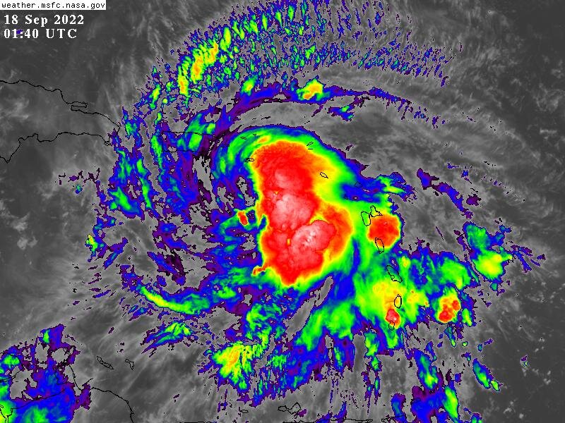
Yeah folks grab your popcorn, this things about to go nuclear. Finally after all of the angst and pain we have something here.
-
STRUGGLE season beginning to not struggle so much. Will be fascinating watching the monster HOT tower roll around the eyewall.
-
RAPID Intensification occurring right now
-
Sorry for the double post but I saw something that peaked my curiousty and I'd love for a pro met to chime in......in the attached image of FIona what are those super cell / hook echo like convective elements on the SW side of the convective envelope?
-
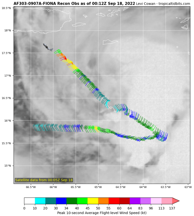
Disagree that it has tightened up despite the pressure being lower. The below recon pattern shows a highly broad windfield, with many wind maxima far away from the actual center. Not sure this is the structure for deepening. EDIT: Seems per radar and recon fix it has the structure of a broad gyre with a tighter center orbiting around. It could explain some of the strange motion between fixes.
-
http://www.meteo.fr/temps/domtom/antilles/pack-public/animation/anim_radar_guad_mf_com.html I sense a center re-alignment going on. Right west of Guadeloupe is where most of the turning is now on radar


