

Normandy Ho
-
Posts
2,641 -
Joined
-
Last visited
Content Type
Profiles
Blogs
Forums
American Weather
Media Demo
Store
Gallery
Everything posted by Normandy Ho
-
While the details are still to be worked out, in my mind the big synoptic picture is somewhat clear. Our Invest will miss the weakness carrying Fiona north and will slide west into the Caribbean under a transient ridge to the north. Once it gets past Hispaniola it will begin to move WNW in response to a weakness developing ahead near the Yucatan. Once near or past Jamaica it begins its recurve into the Eastern GOM. Gonna be some long nights ahead.
-
With the size of the system that is the worst case scenario for Tampa. The eyewall would be just offshore, but the surge would still pound the bay. Also these recurving systems tend to slide east (at least from what ive seen tracking the last 20 years).
-
Going to be one of the wildest ET transitions to witness. Hopefully it bombs during the daytime
-
One of the most threatening storms from a model perspective I can remember in the last five or ten years. Models forecasting a large and extremely intense recurving hurricane that would bring monster winds hundreds of miles inland.
-
One would expect a turn NW soon. But it is very peculiar that its still heading west while already being south and west of the models. mountain interaction could become a factor if the turn is delayed.
-
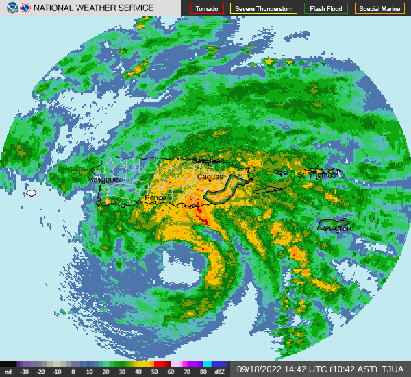
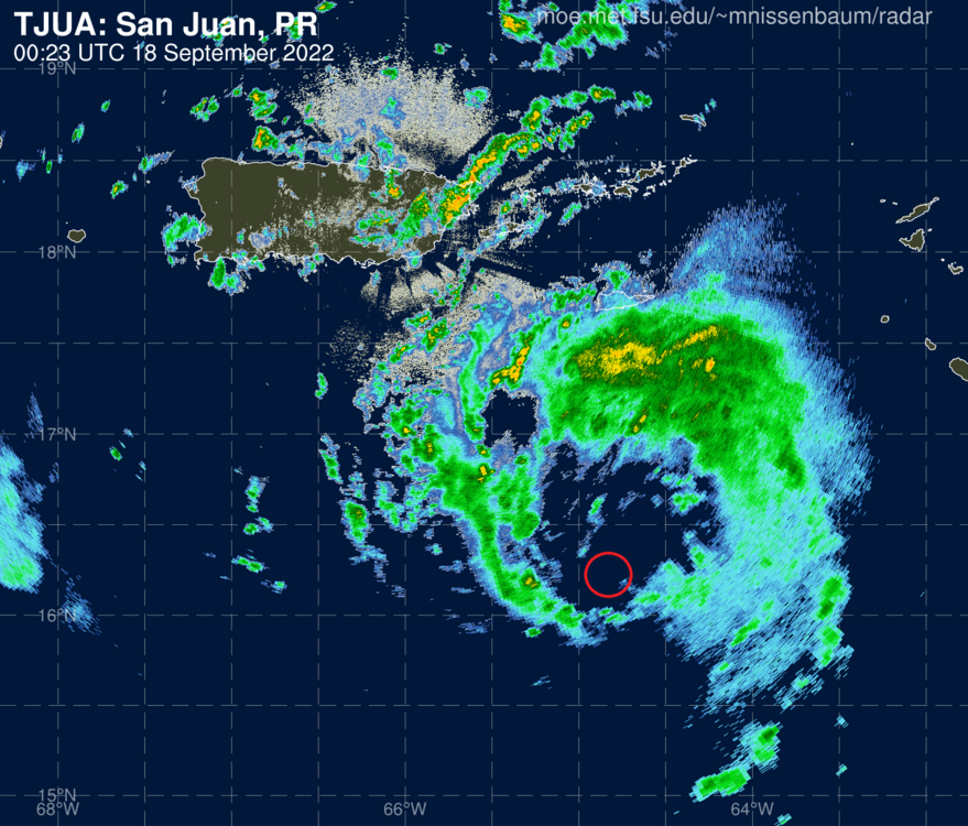
Extreme and devastating rain event on-going in Puerto Rico unfortunately. Radar showing a WSW dive with the eye motion...perhaps the start of the turn more WNW to NW.
-
The turnaround this thing has done from entering the Caribbean as a naked swirl is astounding. I never thought it would get its act together like this.
-
Fiona putting 103 MPH wind gusts on Ponce right now.
-
Big ups for that website! Radar is showing a monster sized eyewall developing
-
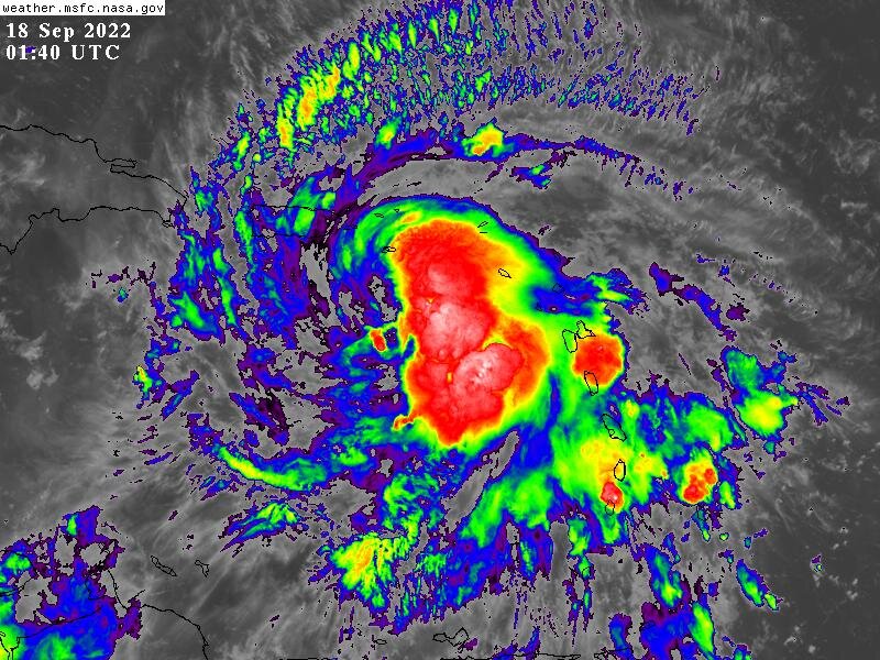
Hopefully somebody is saving an extended radar loop. Its very rare you get to see a rapidly intensifying hurricane develop right next to a radar.
-
Yeah folks grab your popcorn, this things about to go nuclear. Finally after all of the angst and pain we have something here.
-
STRUGGLE season beginning to not struggle so much. Will be fascinating watching the monster HOT tower roll around the eyewall.
-
RAPID Intensification occurring right now
-
Sorry for the double post but I saw something that peaked my curiousty and I'd love for a pro met to chime in......in the attached image of FIona what are those super cell / hook echo like convective elements on the SW side of the convective envelope?
-
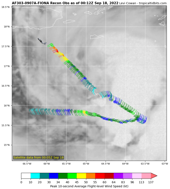
Disagree that it has tightened up despite the pressure being lower. The below recon pattern shows a highly broad windfield, with many wind maxima far away from the actual center. Not sure this is the structure for deepening. EDIT: Seems per radar and recon fix it has the structure of a broad gyre with a tighter center orbiting around. It could explain some of the strange motion between fixes.
-
http://www.meteo.fr/temps/domtom/antilles/pack-public/animation/anim_radar_guad_mf_com.html I sense a center re-alignment going on. Right west of Guadeloupe is where most of the turning is now on radar
-
Peep that WSW motion as well
-
This might be the first time in Fiona's life that convection is on the west side of the circulation. Radar below shows the center straddling 16 N or just above it. http://www.meteo.fr/temps/domtom/antilles/pack-public/animation/anim_radar_guad_mf_com.html
-
The above post is exactly what I am looking at too. We are going to believe this storm, in its current state, is going to slide over this island and immediately start deepening? What would be the outcome if it is still in the same state it is now after going through Hispanola? Interested to hear a pro mets thoughts.
-
I am still dubious of the deepening being shown as its traversing Hispaniola. 2022 has had struggle storms all season and this storm right now is still struggling. OTS is the morning trend thus far.
-
Lets see what the morning model suite shows. One thing I am noticing is that the storm is moving fast and is still highly disorganized.
-
This thing is looking well ahead of schedule
-
Has some definite spin and vorticity but is stretched out east to west (like every system this year)
-
2022 Atlantic hurricane season whining/banter
Normandy Ho replied to GaWx's topic in Tropical Headquarters
There aint no sugar coating this.....we are getting fucked HARD this season. Basin is trash and model runs for rest of the month are trash. -
2022 Atlantic hurricane season whining/banter
Normandy Ho replied to GaWx's topic in Tropical Headquarters
For me its really simple. I enjoy severe weather and enjoy watching it and following it. There are two ways to watch severe weather: Satellite and radar imagery, and in situ documentation via video. The latter requires severe weather to interact with human beings and their belongings (Hurricanes must hit land to become youtube viral videos. Tornadoes must form and plow through things to become youtube viral videos). Now if you ONLY enjoy the former, then the morality argument holds weight. But I know for sure nobody here is just here for the satellite eyecandy alone....we like to see the power in real life (and if you say you don't, well I simply don't believe you). We are all pigs in the mud here. That is why the morality debate to me is pointless. You can apply this same line of thinking to watching football, MMA, boxing, bullfighting, etc.


