Normandy Ho
-
Posts
2,639 -
Joined
-
Last visited
Content Type
Profiles
Blogs
Forums
American Weather
Media Demo
Store
Gallery
Everything posted by Normandy Ho
-
Could not agree more. Their aversion to extreme track changes between advisories and reliance on the GFS rendered their performance in this storm fairly poor for their standards
-
2022 Atlantic Hurricane season
Normandy Ho replied to StormchaserChuck!'s topic in Tropical Headquarters
Like I said in the Ian thread, this hurricane season might change things for Florida and how they operate with respect to development on coastlines. All of those lows I imagine get dragged north by something. -
Good riddance to Ian. One of the wildest storms I’ve ever tracked. There are so many lessons to be learned from all agencies / weather enthusiasts from this storm. one last note to add: the comparison of charley and Ian is such a great case study of how size really really matters, and how two category 4 150 mph storms are not the same animal.
-
Florida either needs to implement policy changes and building codes that prohibit construction in surge zones, or they will have an insurance crisis. These storms are not going away and are getting more frequent. Time to stop putting our heads in the sand.
-
Hurricane Ian landfall location/intensity prediction thread
Normandy Ho replied to Hoosier's topic in Tropical Headquarters
NC/SC Border. 110 MPH. -
Andrew’s only gift to Florida is the new building codes it created. Regarding Ian, it’s structure is that of a superstorm or intense extra tropical low. Is it possible for Ian to attain category 2/3 intensity with such a structure? Would like a Mets thoughts
-
2022 Atlantic Hurricane season
Normandy Ho replied to StormchaserChuck!'s topic in Tropical Headquarters
We are at 8/4/2 and have no idea how active October and November are going to be. A season busting is not one that falls a bit short of expectations. People need to stop this whole “need to make a claim first just so I can be the first to say if and be right” mentality. It’s makes you look stupid. if we are at thanksgiving eating turkey and sitting on 11/5/2….. that’s a bust -
the NHC only mistake was giving the GFS credence. Never in the history of weather has a major hurricane and a trough behaved like the GFS was forecasting. All of the other models eventually caught on and the GFS was still adamant even as it was approach Cuba. If the GFS is alone, it’s wrong.
-
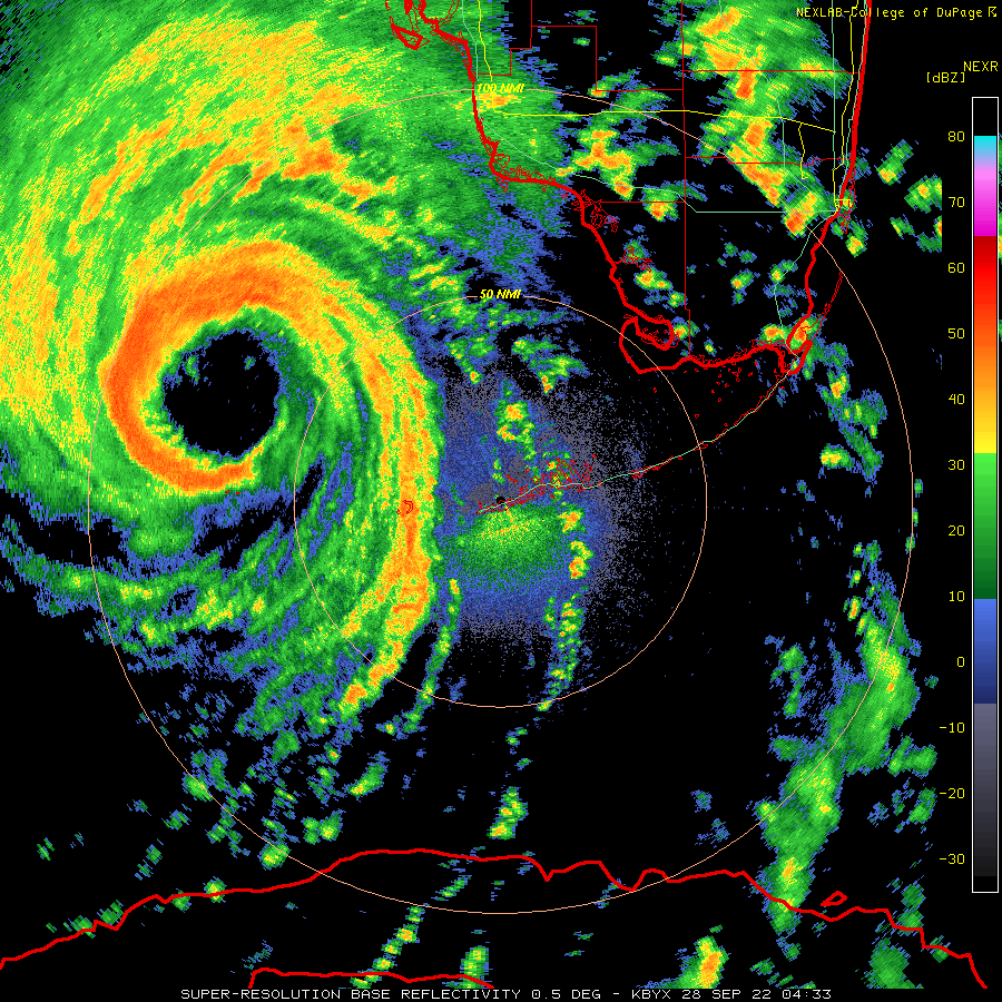
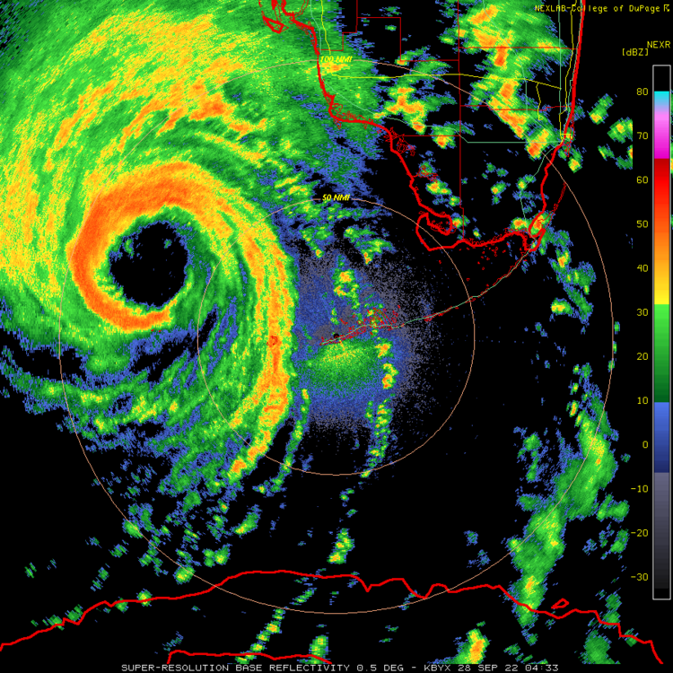
Where can I get that radar image? very neat
-
As he has been his entire life, Ian is east of the track.
-
Can we talk about the irony of Tampa bay not only dodging a bullet, but Tampa residents being able to grab a beer and have drinks on the bay floor? Mother Nature is cruel and hilarious at the same time
-
Earlier photos showed Tampa bay being partially emptied by the offshore winds of Ian. Any coastal flooding in the south shore likely just brought the tide level back to normal.
-
No way this is firing hot towers after landfalling
-
Anybody who chased this on the coast is likely fighting for their life right now. Immense surge flooding on going
-
Hurricane Ian landfall location/intensity prediction thread
Normandy Ho replied to Hoosier's topic in Tropical Headquarters
Give me my money! -
Good news is Ian's CDO is rapidly warming....if Ian can just NOT do that bursting thing that it does perhaps we can give SW FL some kind of better news.
-
Ian is going to produce much more inland wind than charley. Charley was falling apart as it crossed Orlando and was much smaller. Orlando easily sees those gusts (and over three times as long in duration) with this one I think.
-
Ian already showing the difference between he and Charley. Its one thing dealing with 150 mph winds.....a whole other thing dealing with that and tsunami like storm surges. the reverse surge out of Tampa Bay is wild. Historic storm, no other way to describe it.
-
Never seen such violent motion with convection on infrared loops before. Wild ass hurricane man.
-
Several instantaneous winds measured in the 130s and 140s in both north and south eyewall
-
Unreal intensification going on right now
-
I am guessing by the flight pattern recon wants to taste that new convective burst.
-
Excellent Radar presentation. Satellite presentation will follow soon.
-
The trough interaction has made this an absolute monster of a storm. This one will be the benchmark strike for SW FL.
-
The monster hot tower being ejected wnw south of the eye is absolutely wild to see. Monster hot tower on the west side. Insane trough interaction creating a wild outflow jet to the north. The Freak show is about to start I think.