

Hoosier
-
Posts
47,183 -
Joined
Content Type
Profiles
Blogs
Forums
American Weather
Media Demo
Store
Gallery
Posts posted by Hoosier
-
-
29 minutes ago, sbnwx85 said:
I didn't think it would be possible two months ago, but we are now below average on snowfall for the season. What an odd winter...terrible for many snow-lovers.
Nobody's gonna feel sorry when you're near 47 inches.

-
 1
1
-
-
46 minutes ago, michsnowfreak said:
I don't pay close attention to Chicago but I would assume there's been less on the lakeshore than ORD.
That's a good assumption. I can clearly remember some days that produced less around downtown than ORD, and there hasn't really been a lake enhanced event of any significance to make up for that.
-
 1
1
-
-
11 minutes ago, Malacka11 said:
If the snow could at least stick around until maybe another chance next week, then I'd be more enthusiastic but that's not gonna happen so...
Exactly
I guess I'll clarify my other post. I do think it's not out of the question for this to produce at least 6" somewhere, but it would require that it's not a strung out piece of garbage to the tune of the 18z NAM. And in that case, the main snow band would likely end up north of Chicago.
-
27 minutes ago, Malacka11 said:
TBH if it's not at least six inches I really don't want it. Go big or go futility.
Edit: Yes, that's what she said.
I'm not sure there is a feasible way for this to be a 6+ storm in the area. The trough is so positive tilt, which can produce a good snow sometimes, but this is also pretty progressive overall.
-
3 hours ago, Baum said:
the fear of starting a thread for the incoming Thursday system is real. I thought model trends looked a tad better so far this AM. I'm still waiting for that event that strengthens as it approaches. Been awhile.
Did you see the UKMET? Go start that thread... Chicago gon reel her in

-
15 minutes ago, michsnowfreak said:
And yet we've not come remotely close to a Morch since 2012. It's actually pretty sad that anybody in a northern climate like this would wish for that when so many in our states make a living off of growing fruit. Morch was a year long disaster for crops.
This was a pretty wild swing back to back


-
1
-
-
19 minutes ago, michsnowfreak said:
Nah. I just like to troll the troll once in a while when the weather is boring (and it's definitely boring right now). It would be too exhausting to do all the time.
Gotta admit I lol'd at that little montage you put together.
-
1
-
 1
1
-
-
15 minutes ago, Baum said:
the fear of starting a thread for the incoming Thursday system is real. I thought model trends looked a tad better so far this AM. I'm still waiting for that event that strengthens as it approaches. Been awhile.
Over/under on ORD snow amount: 1.35"
-
It's 54/5 at Indianapolis. That dewpoint seems low compared to surrounding obs so not sure if it's erroneous but in any case, pretty dry airmass.
-
5 minutes ago, ILSNOW said:
Euro

I bet that wouldn't even be 2" in Chicago. Mild temps/warm ground leading in would eat away at some of the accumulation in the absence of good rates.
-
-
2 minutes ago, ILSNOW said:
UKMET

There's your thread the needle for Chicago. Weak ass, but a thread the needle nonetheless.
-
1
-
-
Canadian probably went too extreme in the other direction.
-
39 minutes ago, mimillman said:
As long as we get top 10 futility I’m happy. Would be nice to beat 2011-2012
It can only snow 5.7" the rest of the way to get onto the sub 20" list.
9.8" 1920-21
11.5" 1921-22
12.0" 1936-37
14.3" 1948-49
18.0" 1898-99
18.9" 1924-25
19.0" 1901-02
19.0" 1914-15
19.1" 1912-13
19.8" 2011-12
-
42 minutes ago, hardypalmguy said:
In Chicago today. Weather is top shelf with full sun and 51F. Spring might be here early folks.
Bank clock?
-
3
-
-
It's almost unfathomable that I'm going to get through mid February without reaching double digit snowfall. That is very impressive for someone at this latitude who also has Lake Michigan only several miles away. I'm not in the snowbelt, but getting some lake enhancement/lake effect from time to time is not unheard of by any means.
-
3 minutes ago, ILSNOW said:
So if we want snow in Chicago what do we need to see happen?
Physically relocate Chicago to central Wisconsin.
-
4
-
1
-
4
-
-
One thing this setup has going for it (among others) is the lead system that passes by midweek serves to kickstart the moisture return process from the GOM. The cold front with that lead system may only settle down into the central parts of IL/IN/OH. We are still limited by time of year, so don't expect outrageous dews too far north, but this particular evolution with the preceding system means they will be higher than they otherwise would've been.
-
2
-
-
49 minutes ago, Baum said:
going to be brutal having to bump this in 5 days
Agreed. It will be brutal for you when I bump it.

-
It's impressive to see a day 6 risk area outlooked into southern Indiana, given the usual reluctance of SPC to place a day 6 (or even day 4-5) risk area in this sub at this time of year.
-
27 minutes ago, michsnowfreak said:
It's nice of you to be so active this month. You did not post at all the last few Februaries. I wonder why? You must have missed the post from a meteorologist explaining that the CFS site does not match up with weatherbell or other sites. I don't like palm trees unless I'm on a tropical vacation. I have plenty of conifers in my yard, more suited for the northern climate I live in. I would never waste my time to try and grow something thats suited for a climate with an annual temperature 20°+ warmer than my own.
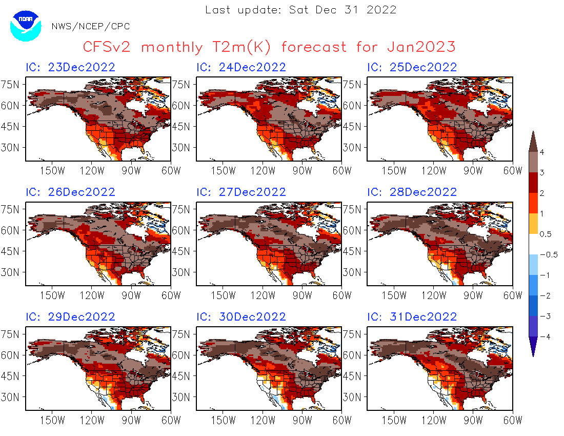
The CFS from that site did well with flagging our warmth in the month of January.


-
1
-
1
-
-
3 hours ago, Baum said:
what should my thread title be after today's 12Z runs be?:
" Madison Special Derailed" or the "The Southeast slider that changed Chicago's winter fortunes"....ill have to decide

-
4
-
-
5 minutes ago, Geoboy645 said:
I don't know what's funnier about that GFS run. MSP having 68" out to 384 hrs or Chicago having 0.5" in that same timespan.
I know which one has a better shot at verifying.

-
1
-
-
3 minutes ago, Blizzard22 said:
Aren’t you worried about sun angle in March ?
.That's more of a problem for long-lasting snow retention or when rates are too light. Heavy enough rates will overcome the sun angle in March, April, and even May if it were to snow hard enough.
-
2
-
1
-

February 2023 General Discussion
in Lakes/Ohio Valley
Posted
I wonder what their total would be right now if they didn't have Lake Michigan upwind. Probably be in the same boat as me... i.e. ~9"