-
Posts
47,183 -
Joined
Content Type
Profiles
Blogs
Forums
American Weather
Media Demo
Store
Gallery
Everything posted by Hoosier
-
The stratosphere says hi. Will be at a very low level especially where you see that maroon blob.
-
Gonna be keeping a close eye on how that is performing upstream relative to models.
-
I'd figure about a 10-12 degree diurnal recovery at ORD, so hope it tanks like crazy tonight to give some wiggle room.
-
So one of the questions with assessing record low potential for tonight around the area is what the thermal structure in that lowest part of the atmosphere looks like. 925 mb temps are progged in excess of -35C into IL, which is astonishing and near record territory. If you have that value at 2m, that is -31F. We are not talking about good radiational cooling conditions tonight with the kind of pressure gradient in place and perhaps some clouds, so the low levels will remain mixed but to what extent? Do we have dry adiabatic up to 925 mb or weaker lapse rates?
-
Even managed a -27 in downtown Chicago. That is like impossible to imagine with the UHI.
-
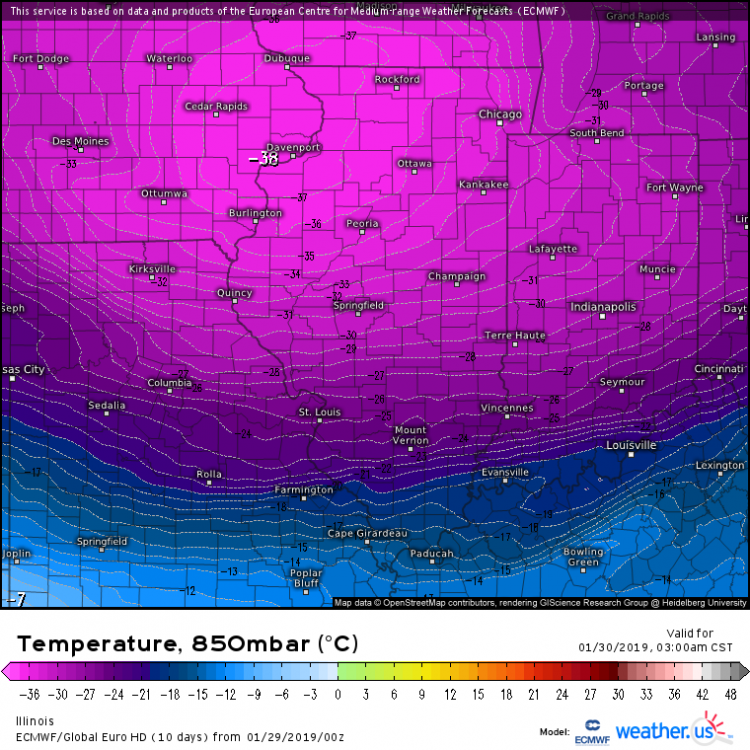
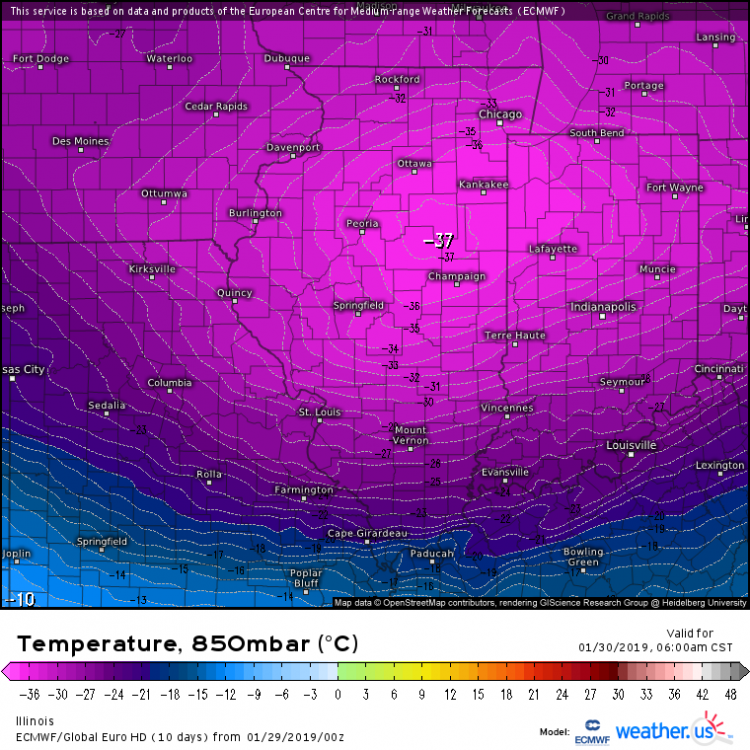
00z Euro is obscene with Thursday lows. Looks a hair colder than 12z overall. Cedar Rapids gets to like -37.
-
Literally had this same thought a little while ago. 80 degree dews back then to what's on the way. Almost like being on a different planet.
-
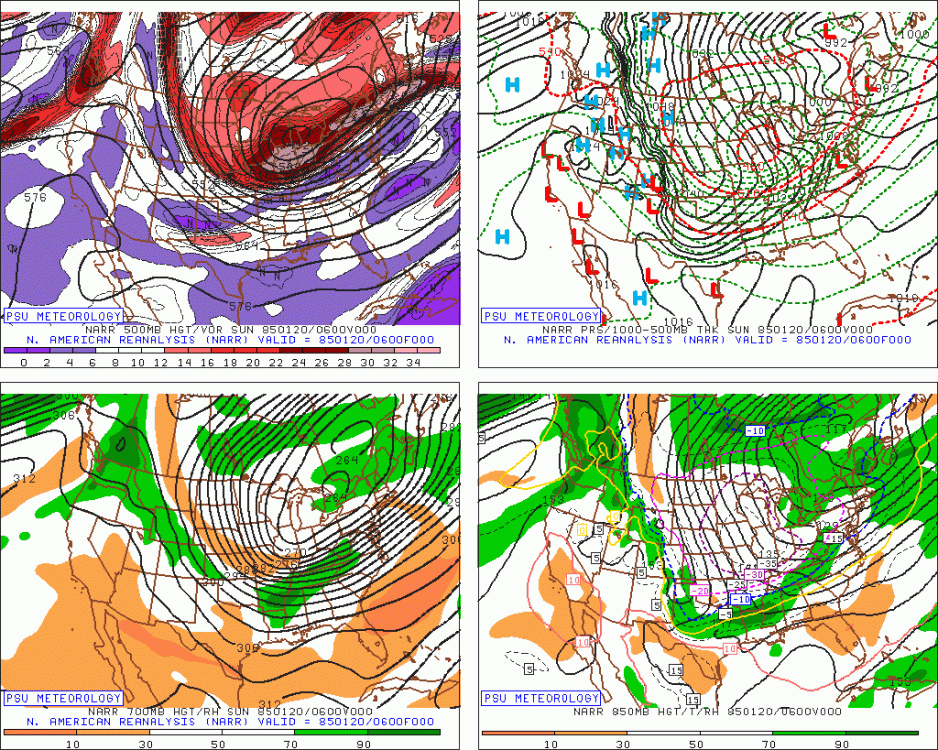
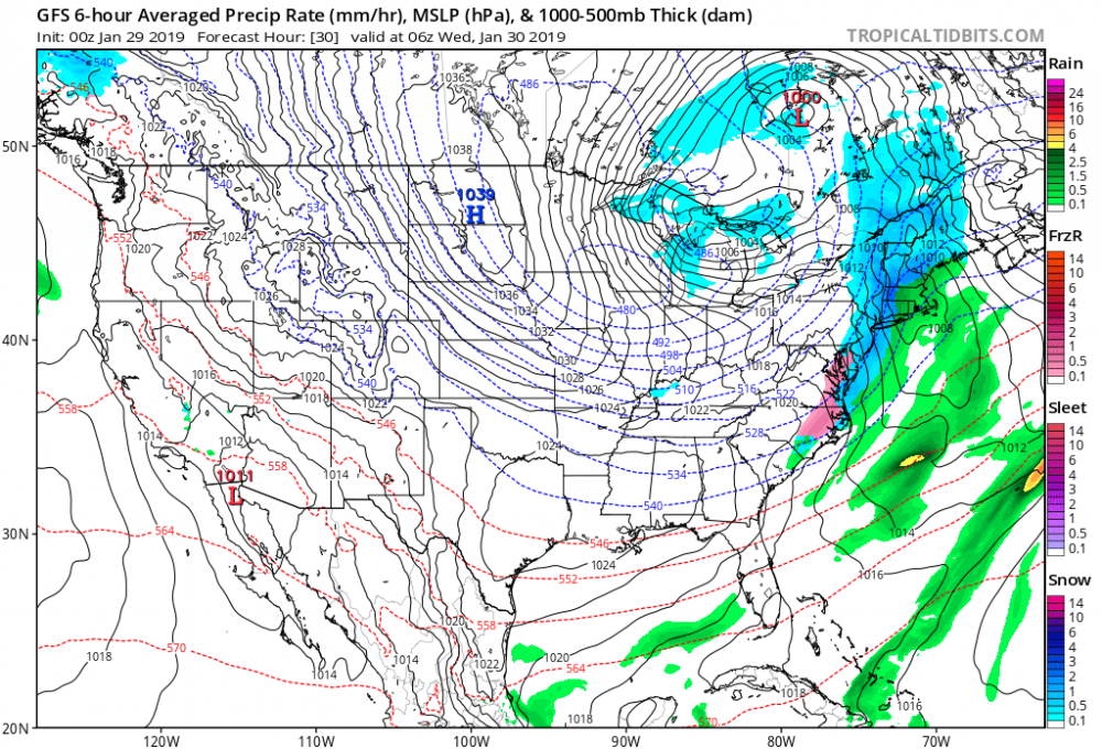
The map from 1/20/1985 compared with GFS prog for 1/30/2019. Look a little similar? No two setups the same, of course.
-
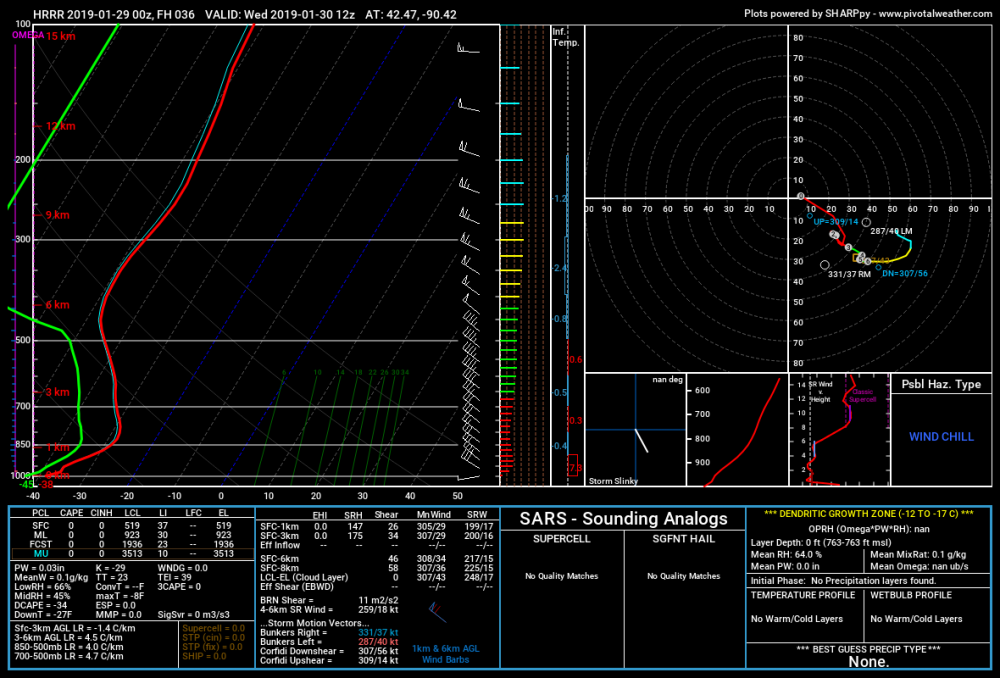
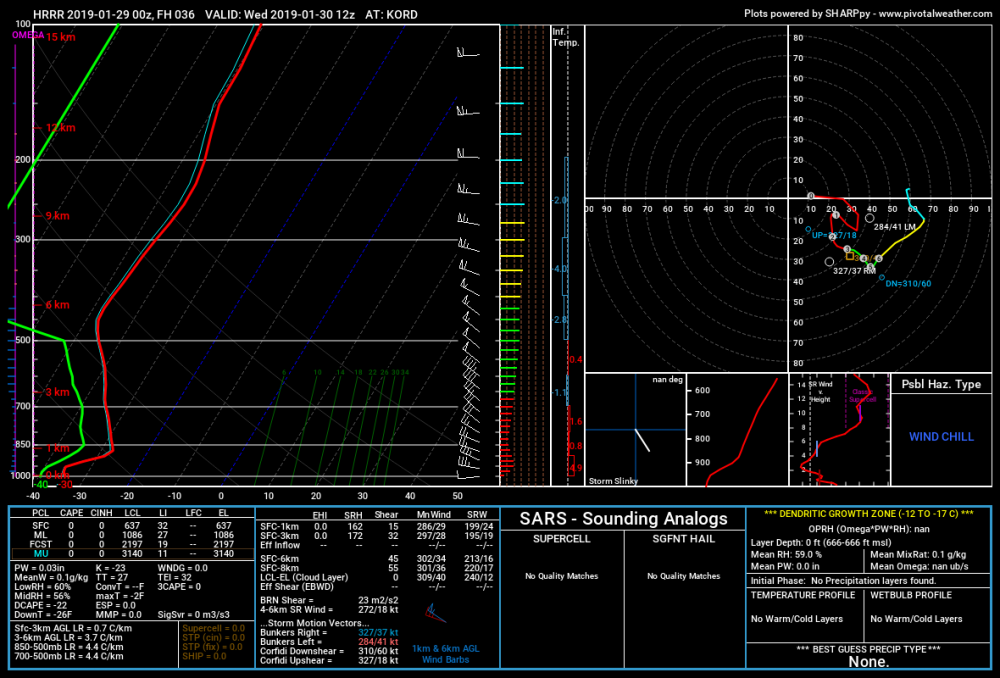
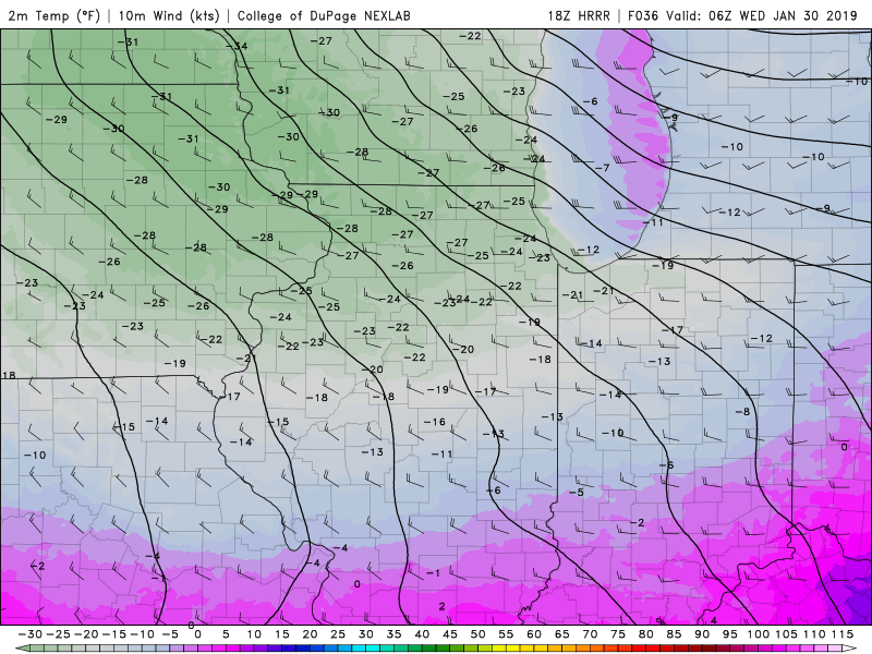
Here are a couple forecast soundings from the HRRR. One is from near Galena and the other is ORD. As you can see, the HRRR tries to establish a strong inversion at the surface near Galena, which is something that may be tough to pull off with the pressure gradient tomorrow night. The ORD sounding does not have nearly as much of an inversion at the surface, but it does have a strong one above the surface. imo, the bigger temperature error potential would be at Galena, since a failure to have a strong surface based inversion would result in temps being way above what the HRRR suggests. The ORD sounding could well be too cold, but the cold that the HRRR has there is not really due to a strong surface based inversion.
-
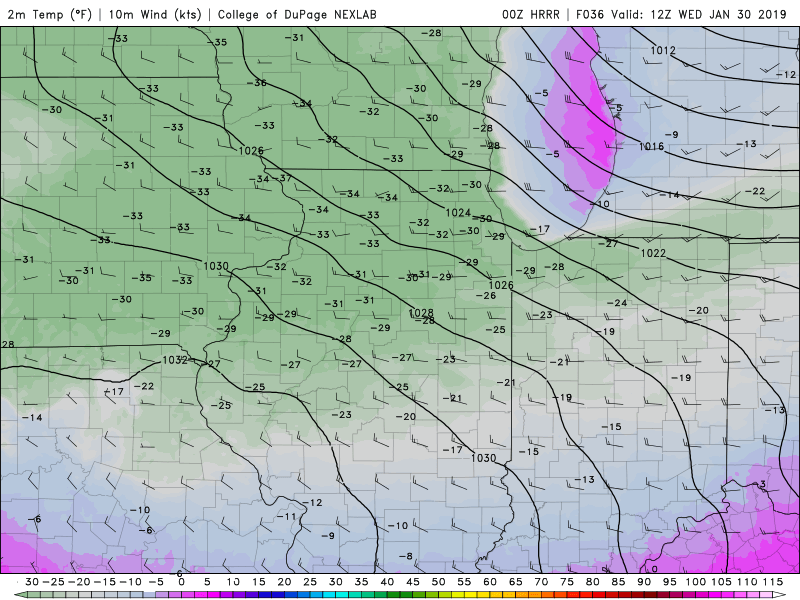
Whether or not anything close to this verifies, can we take a moment to marvel at this kind of widespread cold on a 36 hr prog. And to think that Wednesday night's progs will probably outdo this lol
-
We've been focusing on 850 mb temps but also rare to see a pocket of 925 mb temps of -35C being progged.
-
You'd be a lock for -20s if there were more snow. Even so, I still wouldn't rule it out given the snowpack not far upstream (which applies more to Wednesday morning with stronger low level flow from there) and such a ridiculous airmass aloft. Also, LAF was a fairly good radiator, at least when I was there. So basically I would say both mornings have a chance, but obviously the confidence is not what it is just to your north.
-
How much snow do you have on the ground?
-
The all time Indiana record of -36 looks safe, but wouldn't be surprised to see some spots near -30 in rural northern IN.
-
I think the midnight high danger is just about over. Just thinking back on setups with arctic frontal passages, what is the typical model bias? To not be quick enough with temperature drops behind the front, and I think we're going to see that happen in this case too. I'm not saying go all in with the FV3, but I believe a lean toward the colder/quicker models is appropriate.
-
There's never been -30 at a major reporting site in Illinois outside of the traditional big radiators like ARR.
-
LOT .LONG TERM... 243 PM CST Tuesday through Monday... Lobe of the polar vortex will pivot southeast into the western Great Lakes region Tuesday afternoon into Tuesday night with guidance in excellent agreement advertising record or near record low 500mb heights and 850mb temps. Tuesday, continued and strengthening cold air advection will not only result in minimal rise in temps Tuesday, but also help steepen up the low level lapse rates. The steep low level lapse rates and DCVA associated with approaching strong vort max in the base of the upper low should support at least flurries and likely some scattered snow showers as well during the afternoon. While models largely show little or no QPF tomorrow afternoon, the amount of water vapor in the column at these temps is minuscule and could easily see some respectable snow showers that locally whiten the ground without actually producing measurable liquid precip. Snow showers threat should diminish inversion heights lower and vort lobe passes to our east Tuesday evening. Really very little change in thinking temperature-wise that hasn`t been extensively covered in the past several AFDs. As mentioned in the previous AFD this morning, have gone ahead with a wind chill advisory for 10z Tue through 00z Wed. Wouldn`t normally do a separate advisory, however the forecast duration of the advisory level conditions are easily 12+ hours. Roughly included counties along and northwest of I-55 in collaboration with ILX/MKX/DVN. We ramp the advisory up to a wind chill warning starting 00z Wed and running through 18z Thursday. Winds chills will commonly be 30 to 45 below zero for the duration of the warning with the period of lowest wind chills (likely as low as 40 to 55 below zero) expected after midnight Tuesday night through midday Wednesday. After discounting what we think (and hope) are unrealistically low 2m temps in the GFS and GFS-FV3, we`re left with a suite of guidance that is in good agreement with respect to temperatures. The strong model agreement does help ease the inherent uncertainty in forecasting all time record breaking temperatures. At this point, it appears fairly likely that both Chicago and Rockford will break the daily record cold high temperature Wednesday, as long as temps at 12:01 AM Wednesday (Tues night) are at or below the record low maxes (see climate section for specifics). One notable change in model guidance over the past 24 hours is with respect to placement of the surface ridge axis. There is now strong agreement in said surface high being directly over northern IL and northwest IN late Wed night into Thursday morning. Very deep snow pack, expected clear or mostly clear skies, and light winds with nearby high sets the stage for very strong radiational cooling Wednesday night. As it looks in the model guidance now, hard to envision the all time record low temperature for the state not being threatened or broken at one of the typical cold spots Thursday morning. Both the ECMWF and GEM have fairly widespread temps in the -30`s, and saw no reason to not expand the area of lows colder than minus 30 in the grids early Thur morning. The one saving grace Thur morning with be much lighter, if not calm, winds, which should keep wind chills from being quite as low as Wednesday. Northwest flow clipper system is progged to ride the northwest flow on the heels of departing upper trough Thursday night. This clipper will likely produce a swath of accumulating snow, though at this distance the track this clipper takes is still uncertain. Our CWA is certainly within the cone of uncertainty of the track and we`ll need to keep an eye on this system. In the wake of that clipper, large scale pattern change is expected across the CONUS heading into next weekend. The result will be a more zonal flow which should allow MUCH milder Pacific air to spread into the area. Does look like we could be in a somewhat unsettled patten later this weekend into next week. - Izzi
-
I wouldn't bet on it yet but there is a not impossible/plausible scenario where ORD ties/breaks the current all-time -27F mark not only on Wednesday morning, but Thursday as well.
-
Too bad it appears the coldest 850 mb temps will pass over DVN in between RAOB times. They should do off hour launches for something like this.
-
-
15z RAP already has ORD around -23 at midnight Wednesday, more or less resembling the GFS.
-
I firmly believe the warmest models (such as the NAM) are too warm and will be playing catch up.
-
Special indeed. I am really geeking out over this lol. The greatest arctic outbreaks occurred before I was born or when I was very young, and I've wondered how long it would take to experience something like one of those outbreaks from the 1980s. The answer: less than 3 more days.


