-
Posts
47,183 -
Joined
Content Type
Profiles
Blogs
Forums
American Weather
Media Demo
Store
Gallery
Everything posted by Hoosier
-
This is one of the times I really wish IWX did RAOBs.
-
Watching the ORD 5 min obs, pronounced dewpoint plunge in the past half hour.
-
Agree that the daytime temps don't matter a ton for most areas, but I think it matters more for Chicago specifically.
-
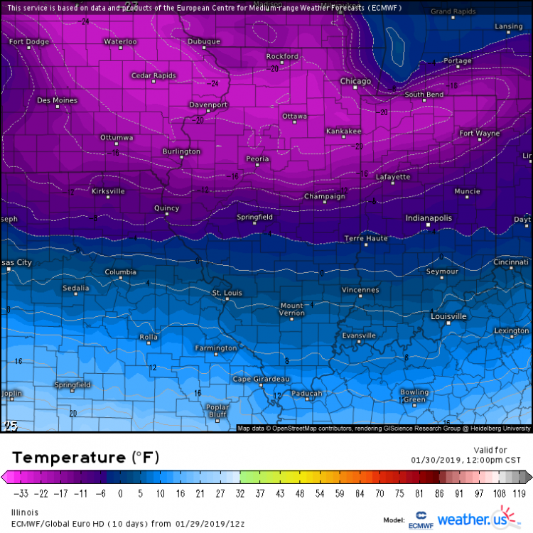
RC, is there a good reason why the Euro is so cold during the daytime? Should have plenty of sun, right? You'd expect more of a recovery than what it shows, especially in urbanized Chicago metro.
-
That pocket of bitter 850 mb temps should be moving through your area right about now.
-
Noticed that Rockford had a nice drop in the past hour. Too bad about ORD. Even though the all-time record low max was missed, it is still extremely rare to have a high as cold as this one will be (only a few occurrences).
-

2018/19 Winter Banter and General Discussion - We winter of YORE
Hoosier replied to Baroclinic Zone's topic in New England
That 850 mb map that Ginx posted is pretty much record territory for Indiana. We are at the mercy of RAOBs being taken only twice a day, so stuff can slip through the cracks so to speak (and there are no RAOB locations in IN) but looking at 3-6 hour reanalysis images of past arctic outbreaks... yeah, -37 basically never happens that far south. Low level lapse rates are pretty steep when those 850 mb temps occur... so while it's very cold at the surface, maybe not as cold as you would think. Tomorrow night is a better radiational cooling setup, but there is a lack of snowcover with southward extent in IN. The overlap of favorable sfc ridge position and deep snowcover is farther northwest... IA/WI/northern IL and maybe northwest IN. Assuming clouds aren't an issue and winds go calm (or nearly calm), there could be some pretty nutty readings in that zone. -
ORD needs to pick it up soon. A -11 midnight temp would be disappointing, even though it would go down as a record since ties count.
-
I don't have to go tomorrow and I'm guessing it will be the same thing for Thursday, which means I may spend even more time on here than usual.
-
Amount of recovery tomorrow will be important. Got to have as cold of a starting point as possible tomorrow night. A radiational cooling setup is not the way you'd draw up breaking the all-time record low for Chicago, but normal rules sort of go out the window if the high can't get much above -15.
-
Based on the current and expected drop rate, about -25 looks good for ORD. Would be nice to see an overachiever though. Just need to get to -22 to beat 1994.
-
Comparing the 00z upper air analysis to the models, the airmass aloft seems a bit warmer than progged.
-
00z RAOB from MPX had an 850 mb temp of -36.5C
-
Can't really make a blanket statement but generally speaking, the NAM looks a touch too warm/slow with the incoming airmass while the other models are running a bit too cold. There are some exceptions but just talking broadly.
-
That sucks. A lot of stuff around here is closing Wed and Thu.
-
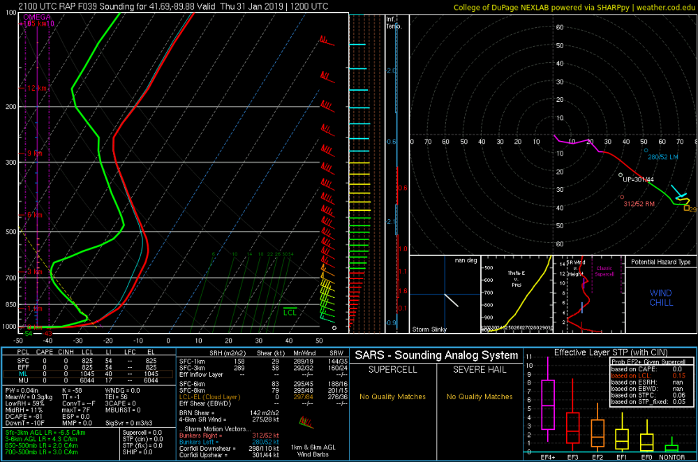
Here's a RAP forecast sounding from northern IL Thursday morning. The mother of all inversions... probably overdone, some. Besides the -43 temp, check out the dewpoint of -54 lol
-
-1 at ORD. Let the hourly streak begin.
-
-
I was at the store to get a few things and you would think a big snowstorm was on the way. People seem to be taking it seriously.
-
Sort of an arbitrary number but if this outbreak plays out right, there's a possibility that more people will have actual thermometer temps of -30F or colder than any outbreak in U.S. history.
-
RC mentioned about the 5 coldest temps for Chicago occurring in advective regimes. This certainly appears like it will be an exception with the question being just how cold it will get.
-
Ricky's afd Area Forecast Discussion National Weather Service Chicago/Romeoville, IL 325 PM CST Tue Jan 29 2019 .SHORT TERM... 325 PM CST Through Wednesday... The much advertised record to near record cold blast is on our doorstep this afternoon. First order of business are the scattered snow showers and blowing snow that are causing impacts in some areas, especially on north-south roads in open areas. Most significantly, DuPage Airport has been reporting 3/4 mile or less visibility since just prior to 1pm and 1/4 mile visibility in heavy snow as of the 2pm hour. Thus the message remains the same, a combo of any falling snow and blowing snow with winds sustained 20-30 mph gusting up to 30-35 mph and briefly 40 mph at times will cause temporary sharply reduced visibility and possibly even brief near blizzard conditions. With the narrow character of these snow shower streamers on radar, also expect to encounter rapidly changing visibility and road conditions. Forecast soundings indicate that the setup will be less favorable for occasional moderate-heavy snow rates in these snow showers this evening and probably lower coverage as well, but did maintain snow shower mention. Blowing snow will continue to be an issue, especially in open areas. Wind chills in the -10 to -20 range as of this writing will fall to solidly 20 to 30 below during the evening commute and 30 to 40 below by the late evening as temperatures quickly fall to below zero area wide and a rapid fall commences during the evening. The core of the coldest air mass will advect over the area after midnight into Wednesday morning, bottoming out in the mid to possibly mid minus 30s Celsius (possibly minus upper 30s) at 850 mb. For reference, the coldest ever observed 850 mb temperature at ILX/PIA/RAN RAOB site is -32.9C on 1/10/1982. This will be true direct Arctic discharge as a lobe of the tropospheric polar vortex clips the region, a hallmark of past historic Arctic outbreaks. The arrival of coldest air mass will likely be marked by a bit of an uptick in the gusty winds overnight, with gusts back up to the 30-35 mph range until or just before daybreak. The low level cold air advection will continue through mid-day Wednesday, thus minimum air temperatures should be reached from 7-9am. With this being an advection cold, am now forecasting the entire CWA to be 20 below or colder, including downtown Chicago. Lowest temps will be about 27 to 28 below, so Rockford certainly has a chance to tie or break its coldest all-time temperature tomorrow morning and it may be close at ORD. Wednesday morning will have the most dangerous/life-threatening wind chills at 50 to 60 below for most of the area due to sustained winds 15-25 mph gusting to 30-35 mph. If you have the option to stay indoors tomorrow, you are urged to strongly consider it, considering the brutal cold and likelihood of at least patchy blowing snow. Have adjusted forecast "high" temps Wednesday afternoon down slightly from already astounding levels to now all areas staying at 10 below or colder and some locations in interior northern IL west of Fox Valley possibly not getting above 20 below. Assuming Chicago-O`Hare is colder than -11 at midnight tonight, which appears likely, then the new coldest high temperature on record appears extremely likely on Wednesday. Have even higher confidence in Rockford setting the new record cold high temp. With air temps in the teens below zero through the afternoon, afternoon wind chills will remain dangerous in the -35 to -45 range even with gradually diminishing westerly winds. For the grand finale of this possibly unprecedented Arctic blast, Wednesday night into Thursday morning appears primed to set records. Models continue to settle on very favorable position of 1035 mb surface ridge axis for strong decoupling over the deep snow pack, along with indication to this point that any high clouds will remain at bay until "the damage has been done" with temps. Suspect that most guidance is too strong with winds, so lowered speeds to below lowest MOS or bias corrected guidance, and wouldn`t be surprised if outlying locations go calm at times. Only possible fly in the ointment would be these above factors trending less favorable, but at this time do not see that occurring. The models have not backed off and in some cases, such as ECMWF, have incredibly trended slightly colder for Thursday morning lows. With the teens below zero starting point, see no reason why favored outlying locations in northern Illinois won`t reach or exceed the state low temperature record (-36F in Congerville on 1/5/1999), thus have continued to forecast as such at locations like KRPJ and KARR and surrounding areas. Would not be surprised if we have some places bottom out at -40F. If RFD does not set new all time record cold temperature Wednesday morning, it appears likely to shatter the record Thursday morning (our official forecast is now -32). There will be more of a urban "heat" island gradient from Chicago to the suburbs as cold will be purely radiational driven. Chicago still expected to have another night/morning of the entire city -20 or colder, and ORD will be very close to the -27 record from 1985. Eye opening that the 12z ECMWF is indicating -30 there and many ensemble members are close to the record. Finally, have added patchy fog mention to the grids outside of Chicago, with the thinking being that rare ice fog formation is possible with the Arctic temps and light winds. Clouds will increase of Thursday afternoon`s clipper, with a better recovery in temps but still locations I-80 and north outside of downtown Chicago may not reach 0 degrees. Castro
-
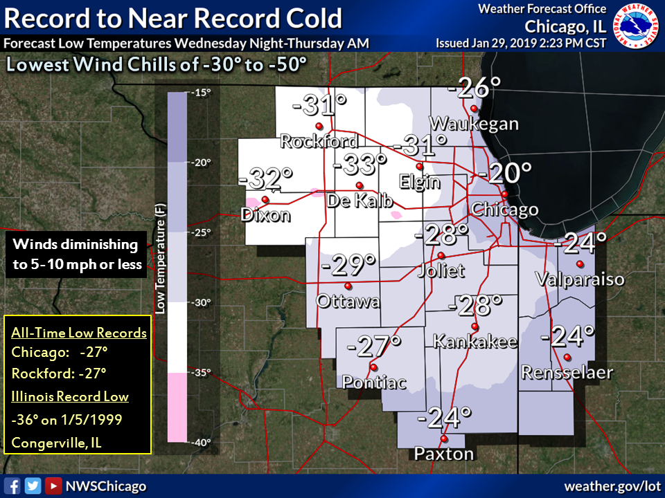
LOT lowered forecast temps a bit. They now have -26 at ORD tomorrow night, -32 at Rockford, and a number of counties in the -30s.
-
Yeah, real shot at one of the typical cold spots. That run even has ORD flirting with -30.
-


